Medieval Fortresses, Burgen, Festung, and Schlosser in Germany
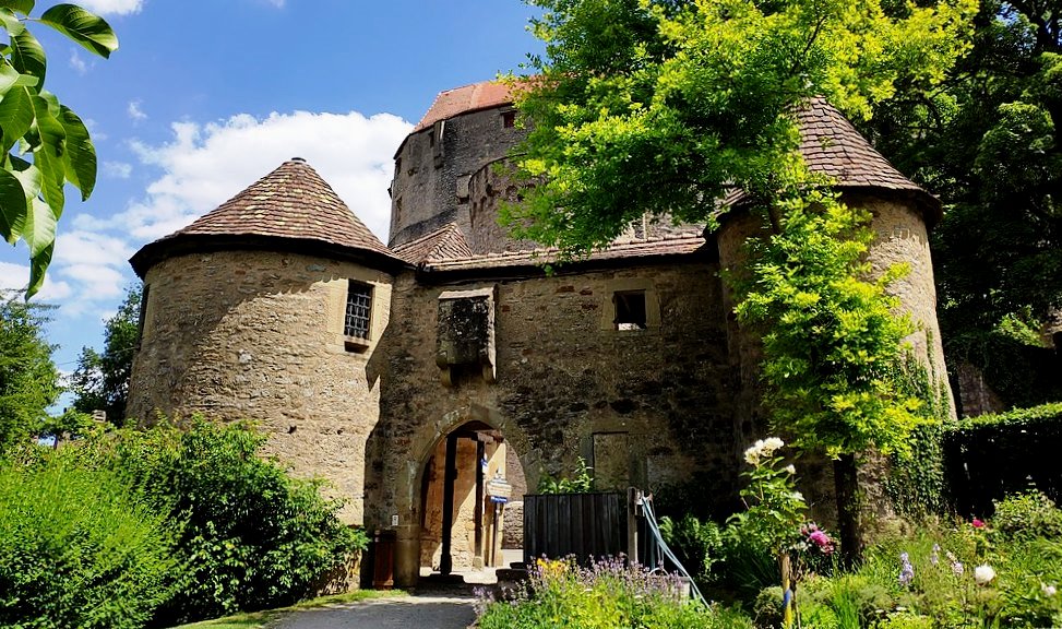
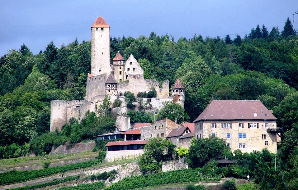
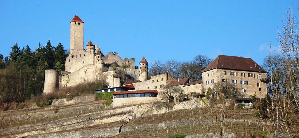
Burg Guttenberg
(peter schmelzle Photo)
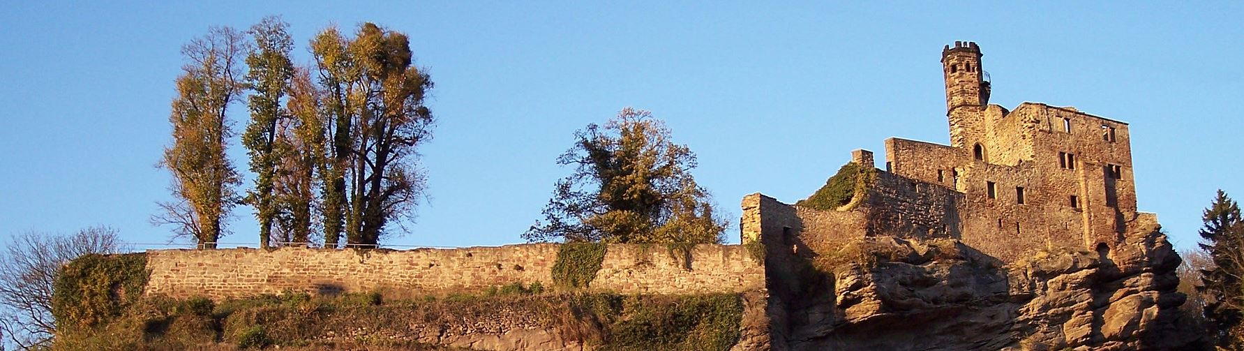
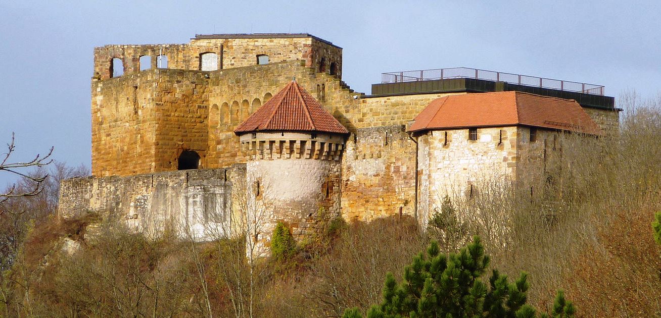
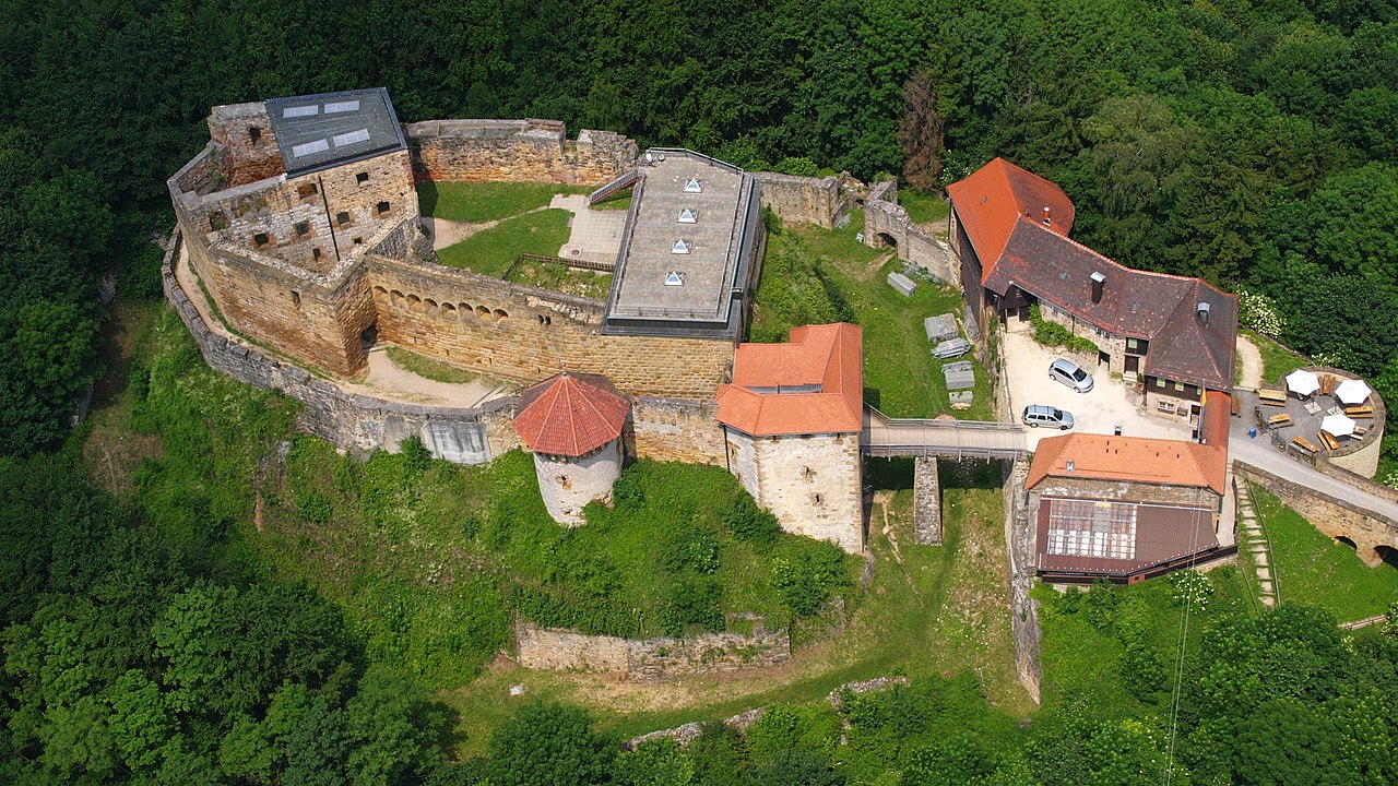
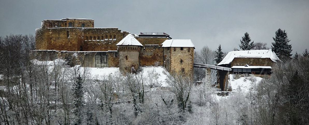
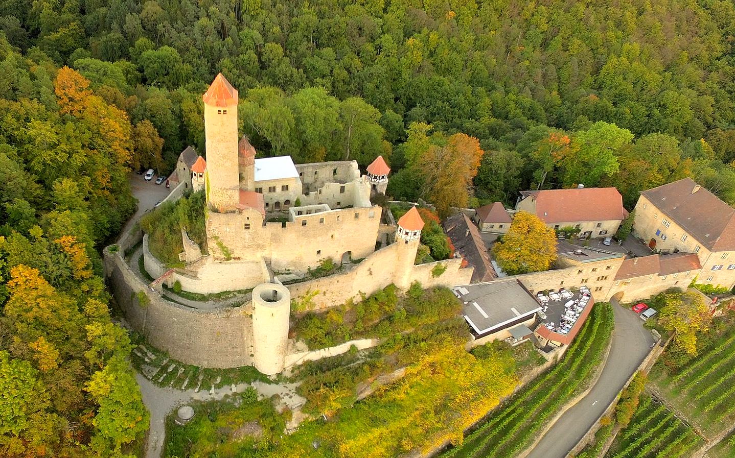
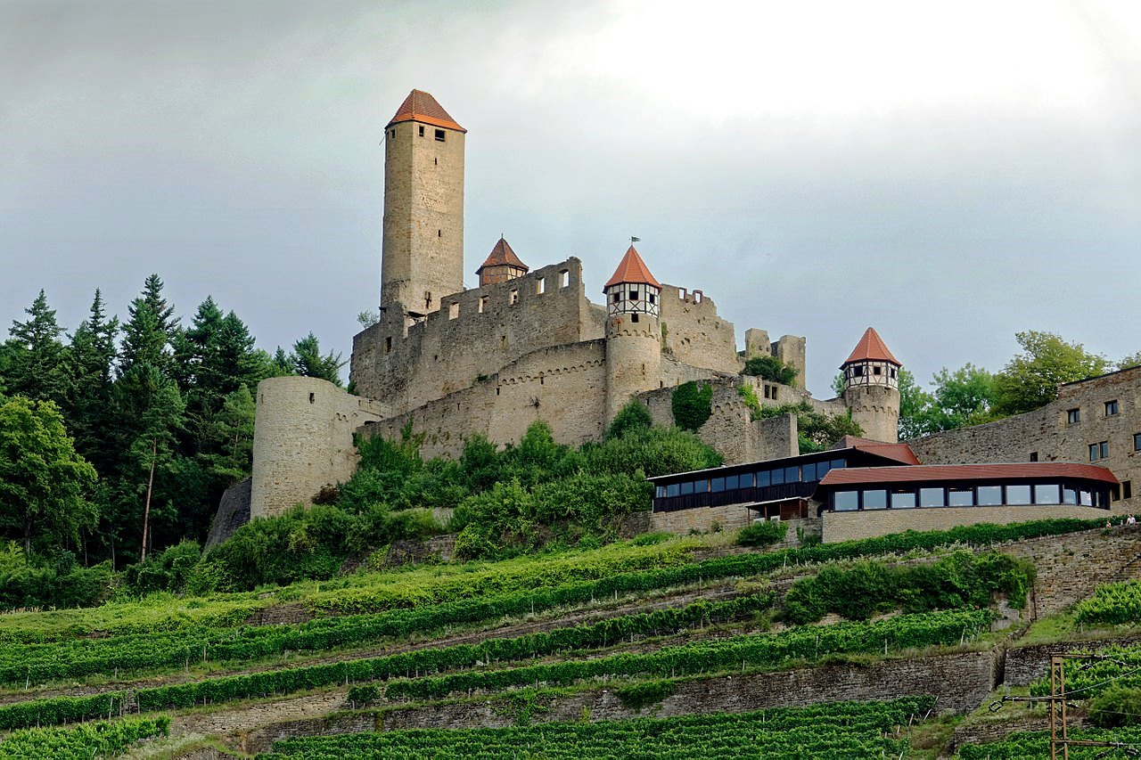
Guttenberg: Burg Guttenberg is a late medieval hilltop castle on the Neckarmühlbach, a district of Haßmersheim in Neckar-Odenwald-Kreis in Baden-Württemberg. The castle was never destroyed and has been continuously inhabited for almost 800 years, from the Gemmingen-Guttenberg line of the Barons of Gemmingen since the middle of the 15th century. The facility houses the Greifenwarte as well as a castle museum and a restaurant. Guttenberg Castle is located near Horneck am Necker, across from Gundelsheim with Horneck Castle and is north of Bad Wimpfen on a mountain spur between the Neckar and Mühlbachtal valleys.
On 1 May 1393, Archbishop Konrad II of Mainz donated a new chapel in Mühlbach, prope castrum nominatum Gutenberg, near Guttenberg Castle. This was the first mention of the castle, which dates from the first half of the 13th century. It belonged to the Lords of Weinsberg as a fief of the bishops of Worms. The von Weinsbergs may have built the castle on behalf of their liege lord. The Bishop of Worms was concerned with securing customs revenue on the long-distance routes in his territory. In a document dated 2 December 1449, the Bishop of Würzburg confirmed that he was the guardian of the sons of the deceased Imperial Treasurer Konrad IX. von Weinsberg sold Guttenberg Castle, along with the associated villages on the Neckar river, including all rights, uses and affiliations for 6000 Rhenish guilders to Hans Rich von Gemmingen. With this purchase, Hans the Rich, became the founder of the Gemmingen-Guttenberg line, which still owns the castle today. With the partition agreement of 1 February 1518, Hans’ grandson Dietrich von Gemmingen inherited the new headquarters of the family. Under him, the castle played a role in the Reformation period, including a providing a place for a religious conference in the Eucharistic controversy of the reformers. There is no evidence of a siege in the Middle Ages, and the castle was not damaged in the German Peasants’ War.
During the Thirty Years’ War, the Catholic troops under Lieutenant General Johann T’Serclais vaon Tilly defeated the Protestant army under the Margrave of Baden in May 1622, in the costly Battle of Wimpfen (1,500 to 2,000 dead on each side). In the Palatinate War of Succession, King Louis XIV of France systematically devastated the Electoral Palatinate and the adjacent areas in 1689. Although troops always marched through the region, Guttenberg Castle was spared in all wars due to fortunate circumstances.
The castle passed through the hands of various branches of the Lords of Gemmingen-Guttenberg. Philipp von Gemmingen (1702–1785), who was favoured in an inheritance division, survived his only son, so that the castle came to the branch Bonfeld-Lower Castle. Beginning with the sons of Ludwig Eberhard von Gemmingen-Guttenberg (1750–1841), the castle was owned by a condominium of several shareholders until 1932. The tourism at the castle was founded by Gustav von Gemmingen-Guttenberg (1897–1973), who took over the castle’s forestry operations in 1923 and founded the sawmill in Neckarmühlbach. In 1949 he set up the castle museum and in 1950 the castle tavern, which was expanded in the following year, in the porch. The arrival of the German police station in 1971 is also due to Gustav von Gemmingen-Guttenberg. After the Greifenwarte moved in, the number of tourists visiting the castle increased considerably. In 1972 the castle tavern was expanded to include a self-service restaurant. Gustav von Gemmingen’s son Christoph von Gemmingen-Guttenberg (1930–1999) and his wife Gabriele continued the administration and expansion of the castle.
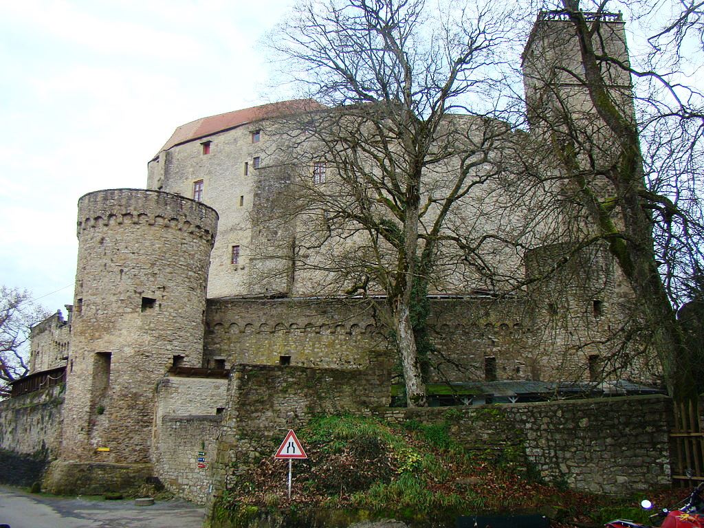
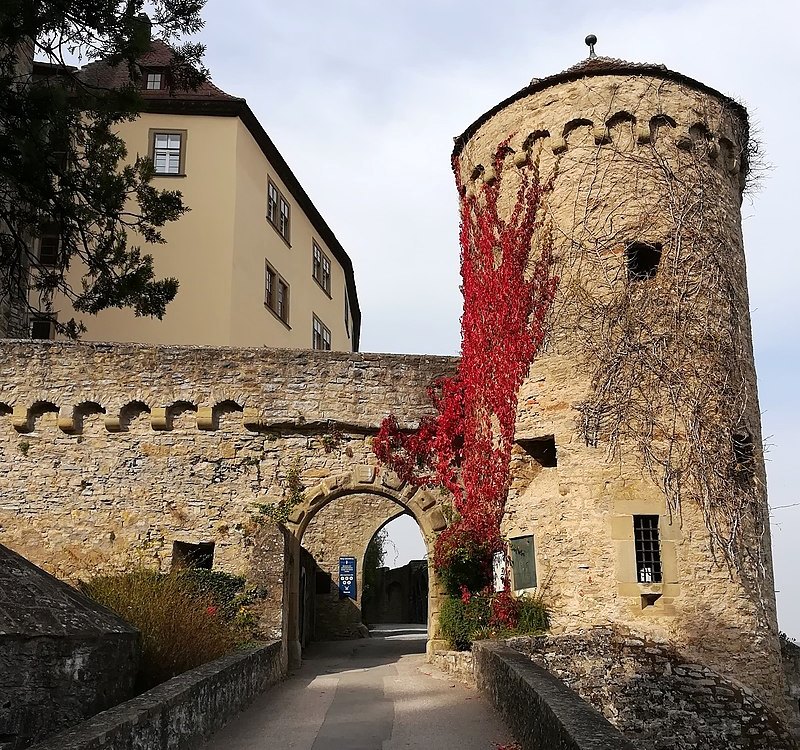
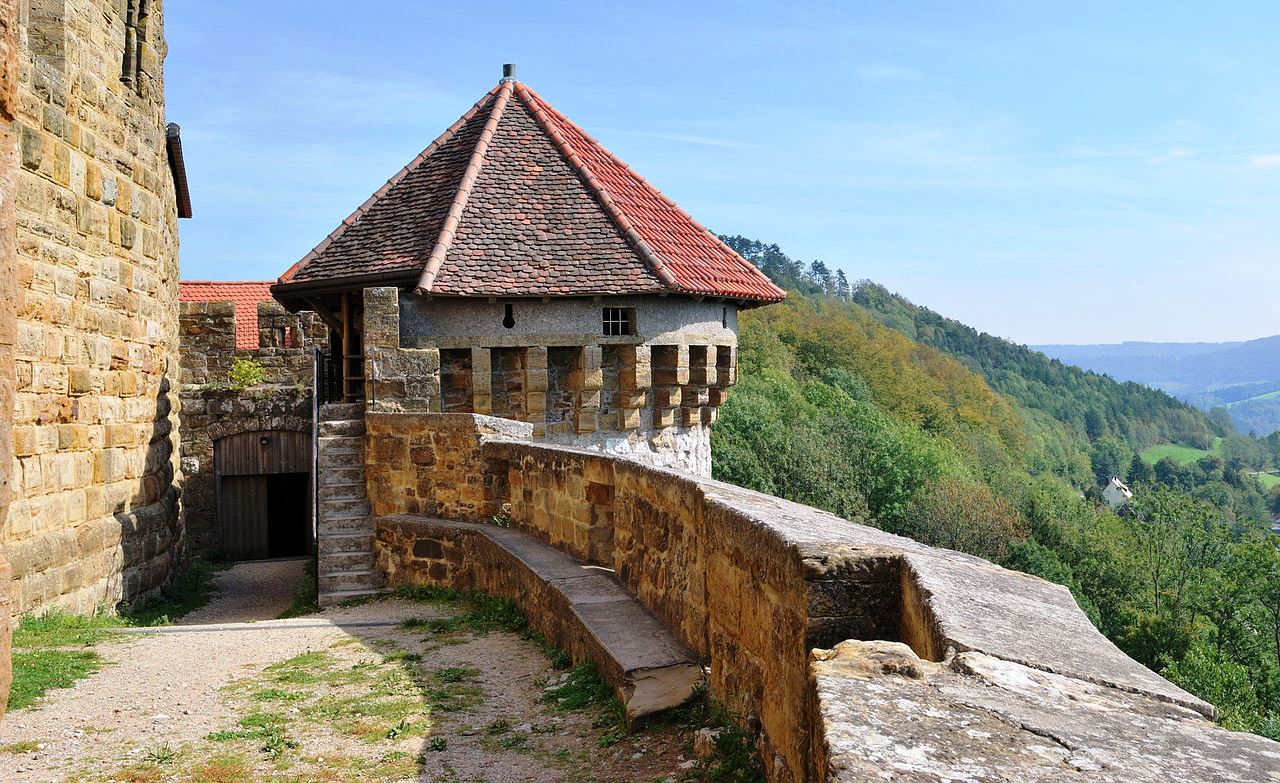
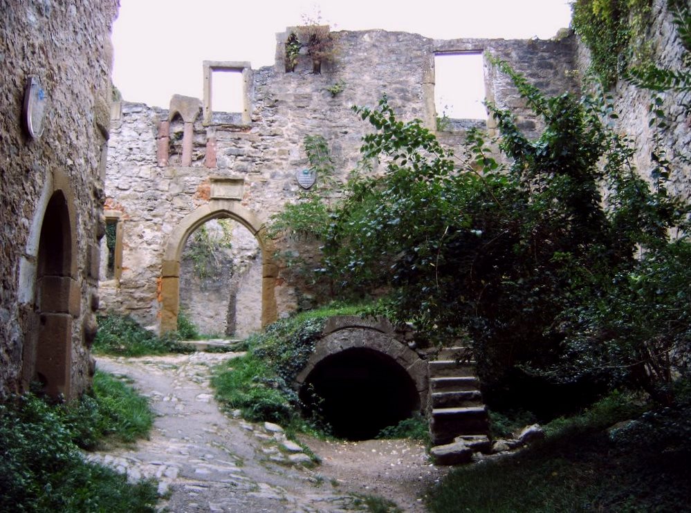
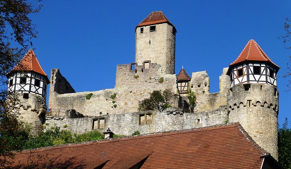
On the street leading west of the castle through the outer bailey, there are buildings dating from the 15th to 17th centuries. The long, two-story quarry stone building from the 15th century is the main structure. The adjoining low, partly timber-framed building directs the view to the gate with the two towers, the entrance gate to the outer bailey in the old days. The path still leads past the castle chapel into the valley. The pointed arch, by a secured gate dates from the 2nd half of the 15th century and was closed by two wooden rotating leaves. The second gate opposite, through which one can visit the castle today, also had its rotating wing on the side facing the outer bailey. The outer bailey behind its wall was therefore lockable and did not serve to protect the inner bailey. The wall surrounding the outer bailey was only opened in modern times because of the driveway on both sides.
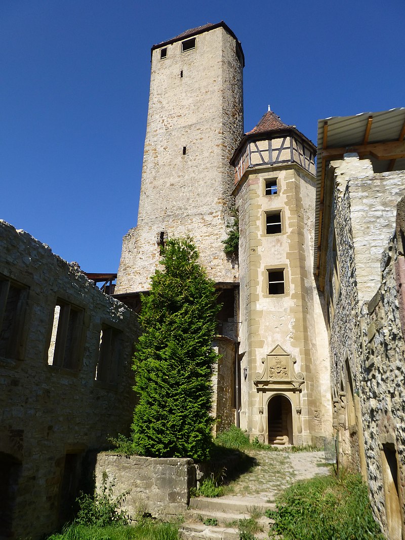
On the way to the main gate of the castle, the mighty shield wall and the 40 m high keep, are impressive. They are located behind the Zwingermauer with a late Gothic round arch frieze that surrounds the entire inner castle. The older wall probably from the 13th century. It was built with five round towers in the 2nd half of the 15th century, under the Lords of Gemmingen. The shield wall is made of quarry stone masonry. A section in the old curtain wall was renewed in the 14th century, and increased in strength at different time intervals. The basement of the keep, made of roughly hewn humpback blocks, tdates from the 2nd quarter of the 13th century. A short flight of stairs leads from the battlement above the shield wall to the entrance floor. The room with a toilet niche and traces of a fireplace was habitable for a gate guard. The defence level above has window niches on all four sides with closable openings for small guns. The two unused floors below the entrance floor had no other function at the time of construction than to raise the tower. This keep never served as a dungeon. The keep with its high entrance was not designed to be a place of retreat in the event of an attack, but was a place of observation for the castle guard. The two stories above the cornice were added in the late 15th century, after the castle passed to the Lords of Gemmingen.
The stone bridge over the neck ditch leads to the main gate, dated to 1572, originally ended a few meters in front of the gate and was lengthened in old times by a drawbridge which has now disappeared . The weakly fortified main gate was built in the late 16th century into the outer wall built in the 15th century. The second gate was added in the 15th century in the older Zwingermauer, which is still visible at this point. The narrow inner courtyard is bounded in the south by the shield wall, in the east and in the west by the residential buildings. Soon after 1449, a four-story residential building was built behind the western curtain wall. This building, preserved in its outer walls, was modernized in the 16th century and received a baroque portal in 1741. The former residential building, which now houses the castle museum, is still in this state today.
On the site of a smaller previous building, probably dating from the 14th century, the new eastern residential building was built in the 16th century. The masonry of the building, which was modernized in the Baroque period, partly comes from these old buildings. A new wing was added to the building in the 18th century, along with a baroque staircase from 1776. The stone balustrade that surrounds the roof of the keep also dates to the late 18th century. Since then, the lords of the castle used the keep as an observation tower, with a view over the Neckar valley to Hornberg Castle and Horneck Castle. The medieval hilltop castle with its keep from the Staufer era was modernized again and again still today it is a center of the extensive family of the lord of the castle.
While the private rooms of the castle owners are in the eastern residential building, the castle museum is in the western one. Here the visitor is provided with information bout knighthood and medieval jurisdiction. The keep can be climbed during the opening hours of the museum and offers a wonderful view over the Neckar valley. Guttenberg Castle is widely known for the accommodation of its bird sanctuary, the Greifenwarte. (Georg Ulrich Großmann, Hans-Heinrich Häffner: Guttenberg Castle on the Neckar. 1st edition. Schnell + Steiner, Regensburg 2007)
(Johannes Bökh Photo)
Burg Guttenberg, southwest gatehouse.
(Alexander Migl Photo)
Burg Guttenberg.
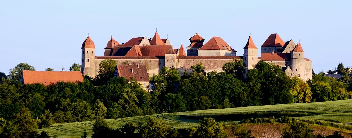
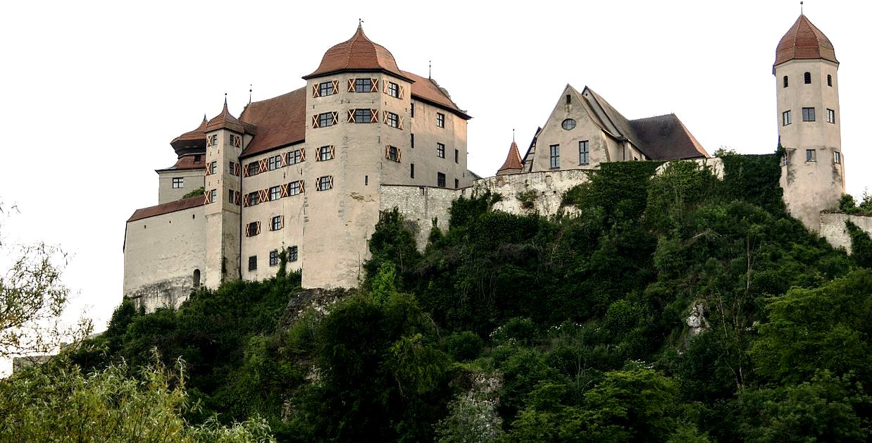
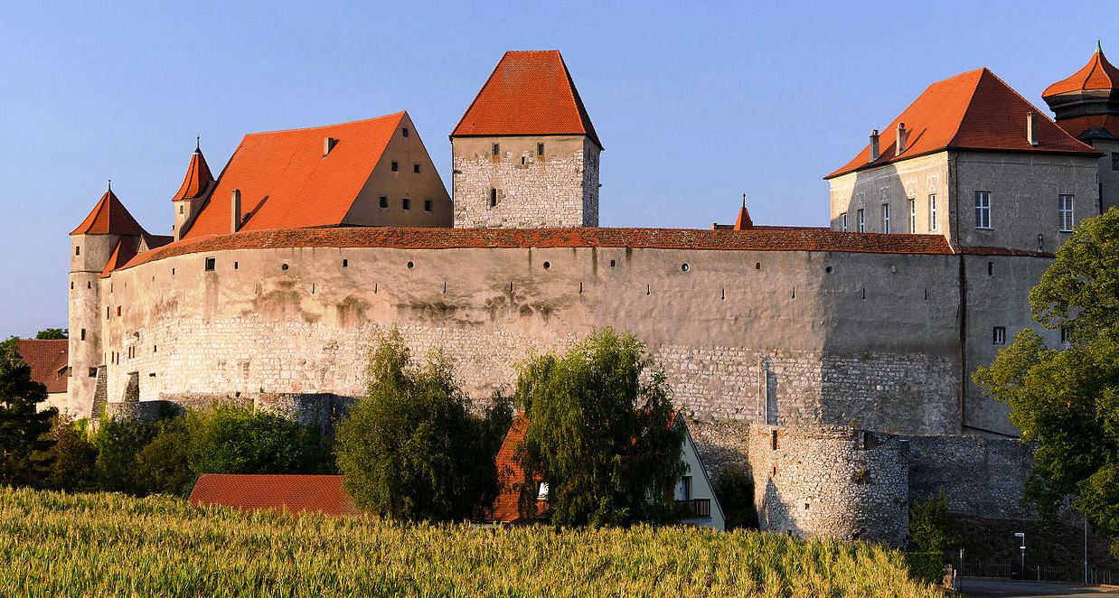
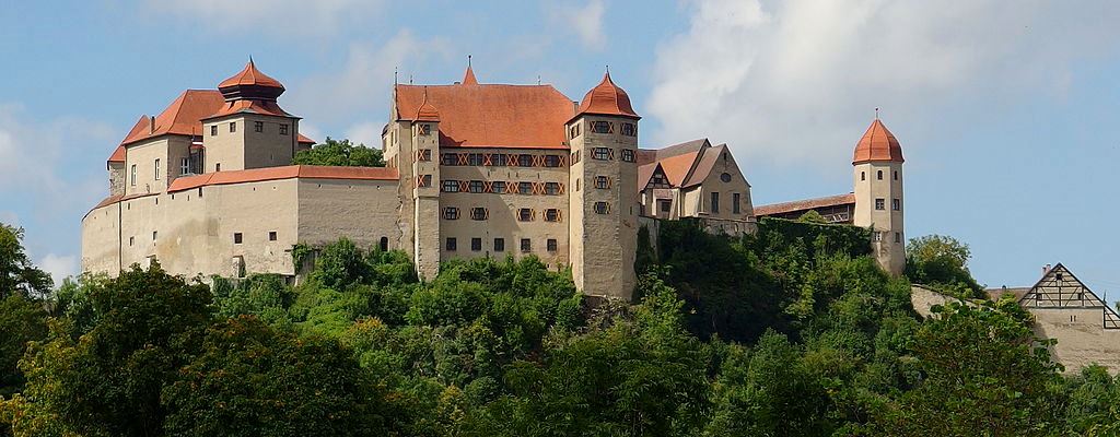
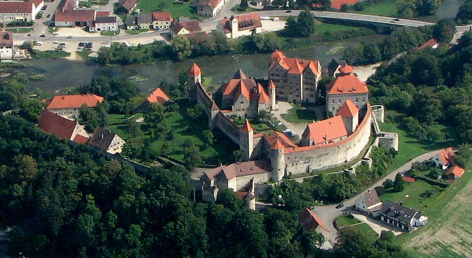
Burg Harburg
(p.schmelzle Photo)
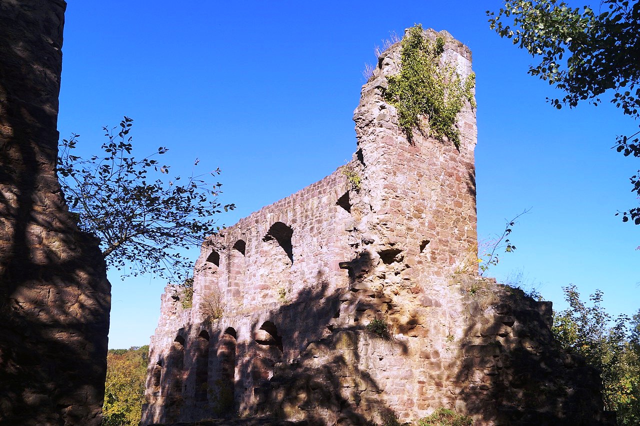
Harburg: Burg Harburg is an extensive mediaeval castle complex dating from the 11th-12th century in Harburg, Bavaria, in the Donau-Ries district. Originally a Staufer castle, now it is owned by the princely House of Oettingen-Wallerstein. The first record of the castle is dated 1150, when the Staufer Henry Berengar wrote a letter to his aunt Bertha of Sulzbach, Empress of Byzantium. Harburg Castle was likely built in the 11th century, because at the end of this century Cuno de Horeburc (Kuno of Harburg), a noble man, was well known. In 1530 the historian Hieronymus was a clerk at Harburg Castle.
Burg Harburg is a completely preserved hill castle with a remarkable building complex dating from the Middle Ages. In the 15th century the fortress was extended with residential buildings. From the 16th to the 18th century further extensions completed a prince’s residence (ceremonial hall, castle church). A fairly unique element is the particularly well-preserved, late-medieval ring wall with defensive corridor. (Jürgen Dendorfer (2004), “Adelige Gruppenbildung und Königsherrschaft. Die Grafen von Sulzbach und ihr Beziehungsgeflecht im 12. Jahrhundert.” Studien zur Verfassungs- und Sozialgeschichte (in German), München)
(Tilmann2007 Photo)
Burg Harburg.
(Tilmann2007 Photo)
Burg Harburg.
(Tilmann2007 Photo)
Burg Harburg.
(Rikiwiki2 Photo)
Burg Harburg.
(El-mejor Photo)
Aerial view of Burg Harburg.
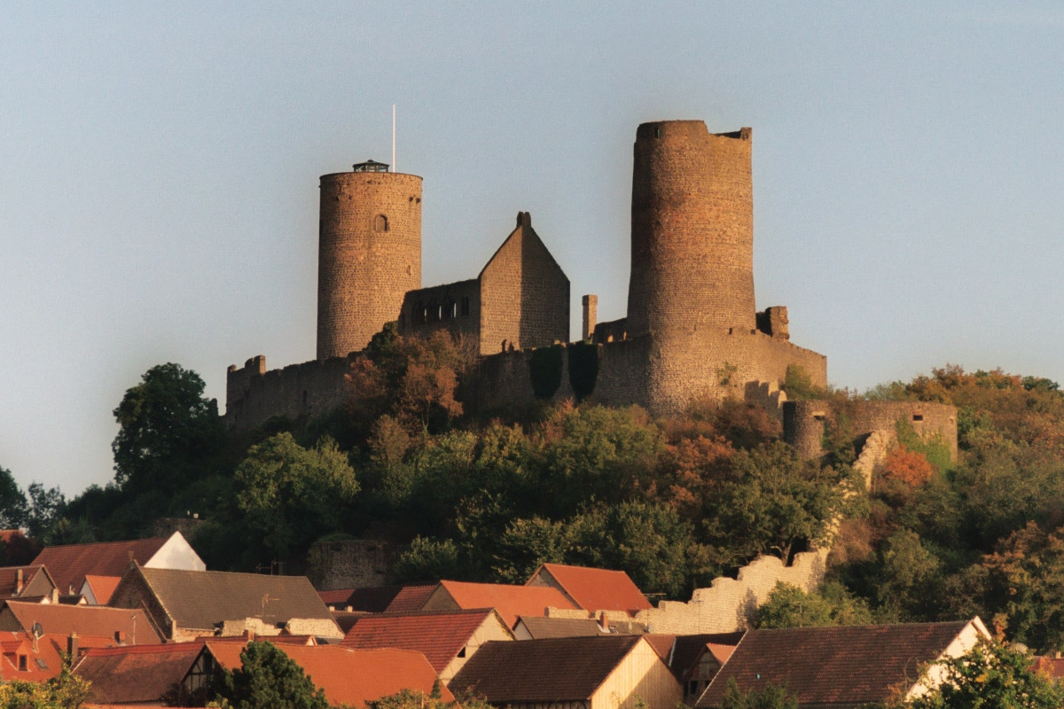
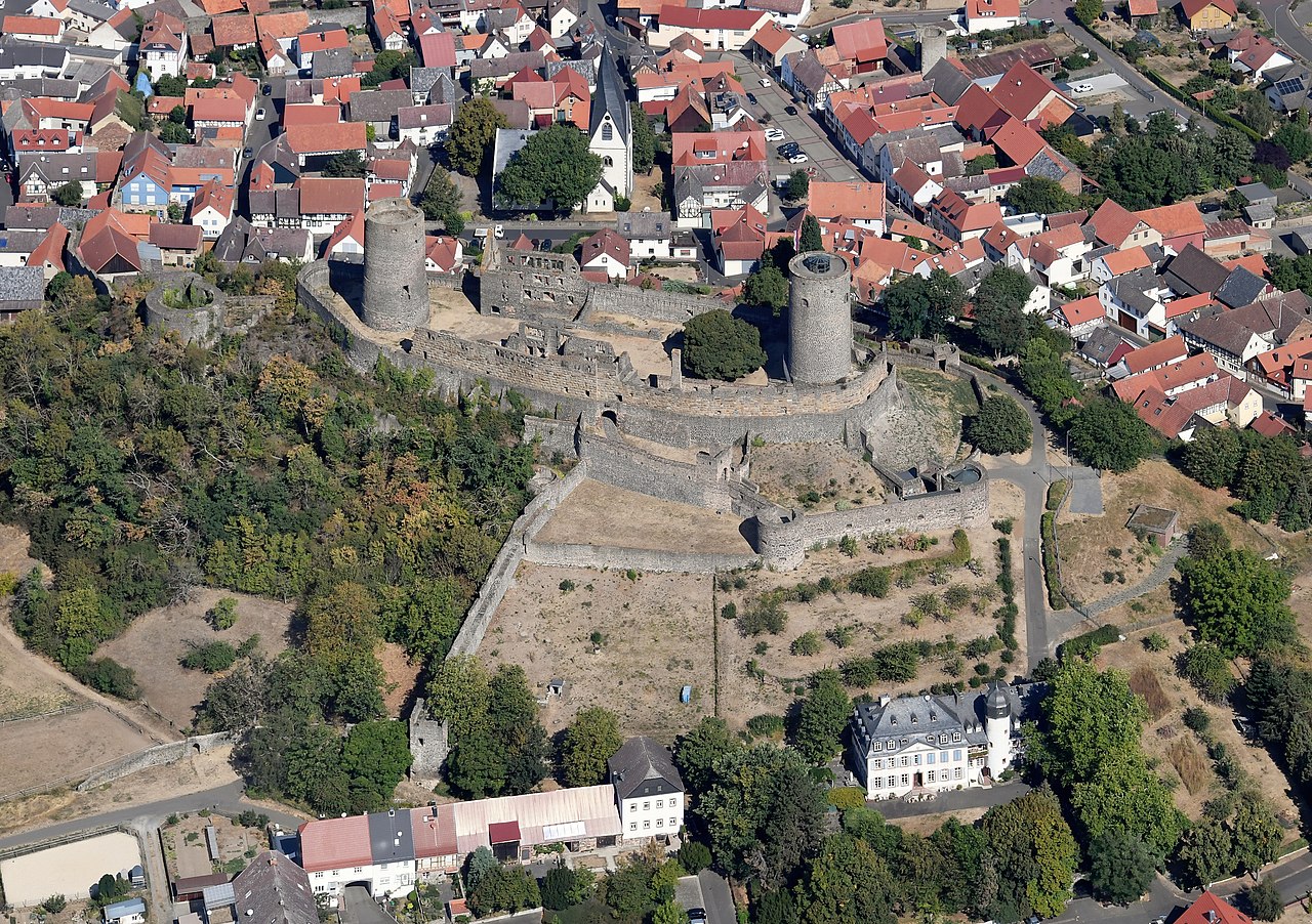
Burg Hardenburg
(Axel Heindemith Photo)
Nörten-Hardenberg: Burg Hardenberg is a castle ruin in the district of Northeim in Lower Saxony. Burg Hardenburg is first mentioned in 1101, and was built by the Electors of Mainz. Their Ministeriales (or Burgmann) were the lords of Rosdorf, who were expelled in 1287, followed by the lords of Thüdinghausen (near Moringen) who took on the name knights of Hardenberg. The family acquired further properties near Nörten-Hardenberg, as well as in other regions of Northern Germany. Since 1409 Hardenberg Castle has been split between two family branches. The castle was partly destroyed by a thunderstorm in 1698, and abandoned in 1720, becoming a ruin. In 1778 the Hardenberg family became counts, whose most prominent member was Karl August von Hardenberg, Prime Minister of Prussia. They still own the estate. Since 1710 the family has lived in the nearby manor house. In 1700, they founded the Hardenberg-Wilthen distillery, today Germany’s second largest liquor producer.
Burg Hardenberg, 1648, Merian.
(Dewi König Photo)
Burg Hardenburg, Nörten-Hardenberg.
(Dewi König Photo)
Burg Hardenburg, Nörten-Hardenberg.
(Lumpeseggel Photo)
Burg Hardenburg, Nörten-Hardenberg.
(Carlos-X Photo)
Burg Hardenburg, Nörten-Hardenberg.
Burg Hohenrechberg
(Geak Photo)
Schwabish Gmund: Burg Hohenrechberg (High Rechenberg), ruins of a medieval Spur castle, south of Schwabisch Gmund, near the district of Rechenberg in Ostalbktreis, in Baden-Württemberg. The castle ruins stand 644.2 m above sea level, on the western shoulder of the Rechberg witness mountain, one of the Three Kaiser Mountains on the northern edge of the Swabian Alb. The most likely builder of the castle was Ulrich von Rechenberg, first mentioned in a document in 1179. The Hohenrechberg Castle was built between 1200 and 1250. It was mentioned for the first time in 1355. Hohenrechberg Castle served as a Staufer Dienstmannenburg, and was the ancestral seat of the later Counts of Rechberg. It formed the historical and administrative center of their dominion.
From 1448 to 1450 soldiers from the imperial cities of Schwäbisch Gmünd and Schwäbisch Hall plundered the area around the castle, but did not dare to attack it. During the Peasants’ War in 1525, the Hohenrechberg was spared from the pillaging farmers. However, the castle residents could not prevent the Lorch and Adelberg monasteries and the nearby Hohenstaufen Castle from being burned down. In 1546 the Schmalkaldische Bund moved up in front of the castle, but it remained intact. In contrast, Schwäbisch Gmünd was taken. The castle was rebuilt and expanded several times. Until 1585 the rulers ruled directly from their ancestral castle.
The castle was occupied by the French in 1648 during the Thirty Years’ War and in 1796 during the French Revolutionary Wars. They did not destroy it, but in 1865 the castle was ruined by a fire caused by lightning. The ruin has been an outstanding sight on the Staufer road since 1977. Up until 1986, the castle was owned by the noble family. At that time it was sold to a private citizen in Göppingen. The irregular, polygonal castle complex has a ring wall with humpback blocks, a Hohenstaufen palaces next to the rectangular projecting gate and a 30-meter-deep castle well. The castle chapel has not been used since 1806. (Walter Ziegler: Stauferstatten im Stauferland, Walter Ziegler (Ed.), Konrad Theiss Verlag, 1977)
(Tuweri Photo)
Burg Hohenrechberg, view from the East.
(Skyscraper Photo)
Burg Hohenrechberg, aerial view.
(Rake Photo)
Burg Hohenrechberg.
(Pwagenblast Photo)
Burg Hohenrechberg, winter view.
Burg Hornberg
(AlterVista Photo)
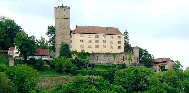
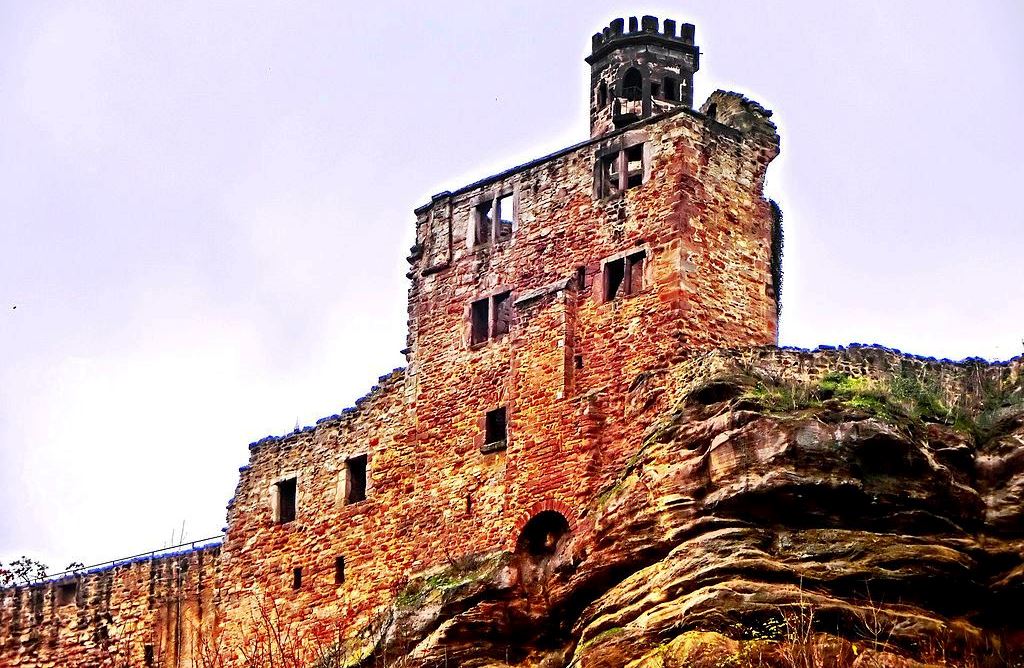
Neckarzimmern: Burg Hornberg is a partially ruined castle located on a steep outcrop above the Neckar valley above the village Neckarzimmern, between Bad Wimpfen and Mosbach. It is the largest and oldest castle in the valley.
The original castle was built in the 11th century. It is notable as the stronghold of Götz von Berlichingen, who bought it in 1517 and died there in 1562. The castle was bought by Reinhard of Gemmingen in 1612 and remains in possession of the Gemmingen-Hornberg family today. It was uninhabited from 1738 and left to decay until 1825, when it was partially restored. It has housed a museum since 1968. It also housed students from the University of Wisconsin-Stevens Point College of Natural Resources for an annual summer exchange program. (G. H. Bidermann: Burg Hornberg, Wohnsitz des Ritters Götz von Berlichingen, Rüstzeugschau 1980. Journal Verlag Schwend GmbH, Schwäbisch Hall 1980) Visited 9 April 1990.
(Bgabel Photo)
Burg Hornberg.
(Castellan Photo)
Burg Hornberg.
(Muck Photo)
Burg Hornberg, keep, stair tower, and on the right the Palas of the Lords of Berlichingen.
(Muck Photo)
Burg Hornberg.
Burg Hornberg, c1600.
(Aerial Video Capture Photo)
Burg Hornberg, aerial view.
(Holger Uwe Schmidt Photo)
Burg Hornberg.
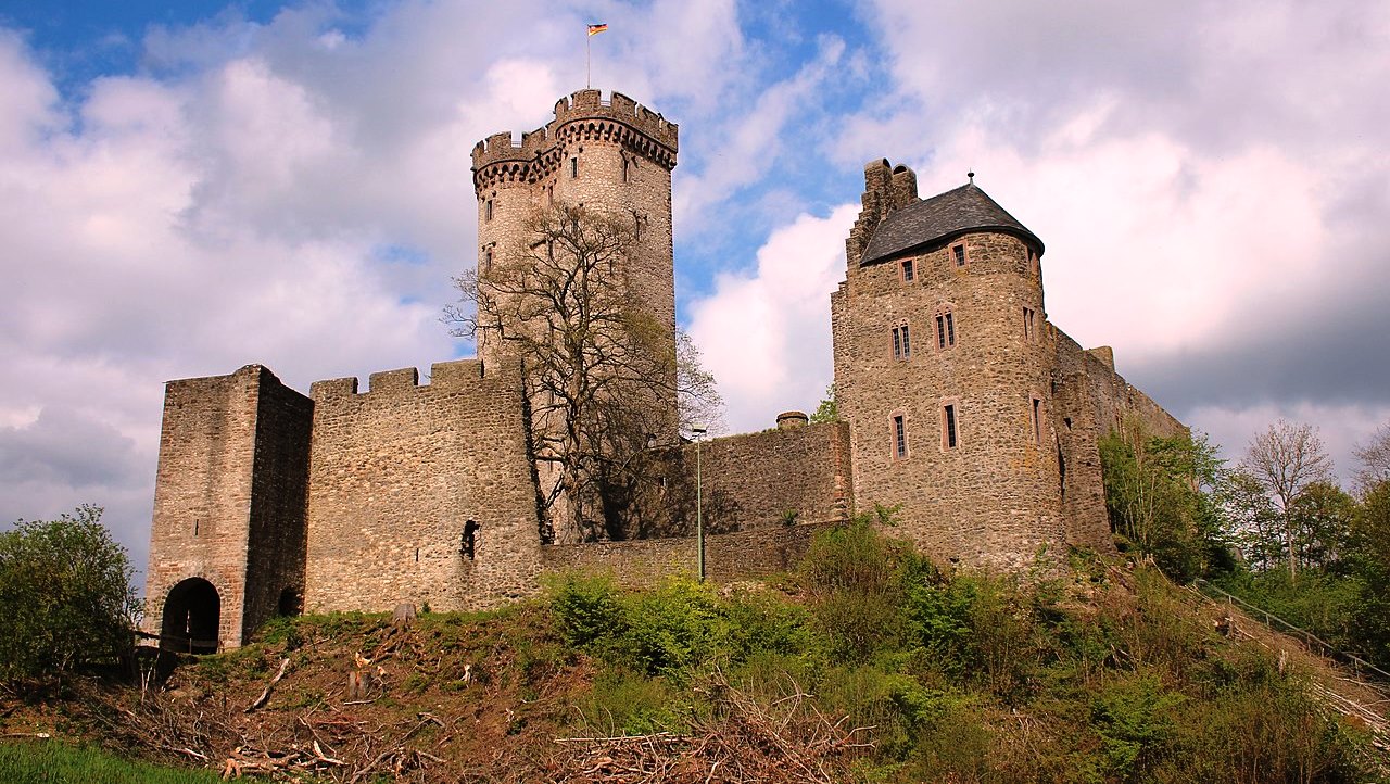
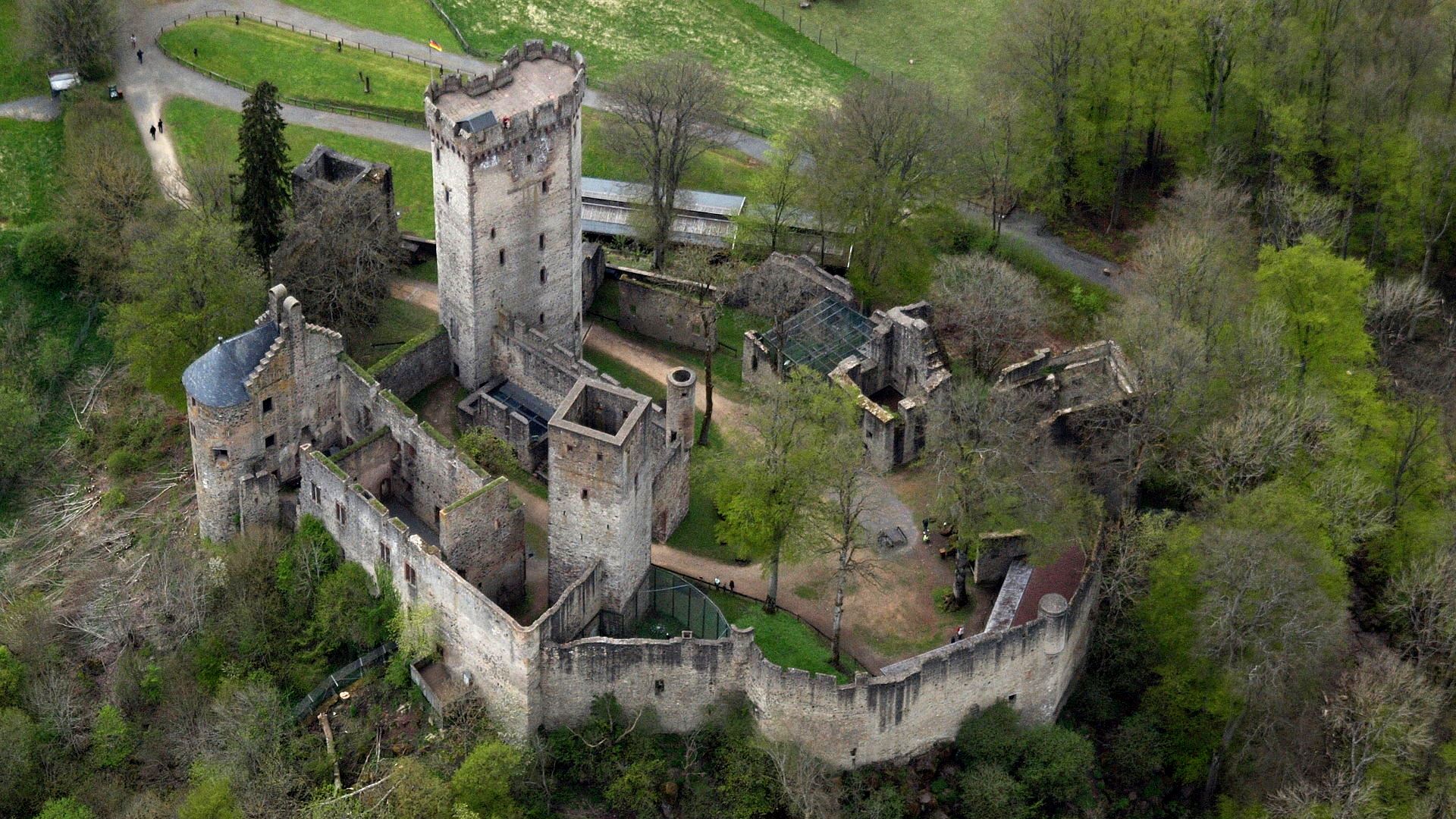
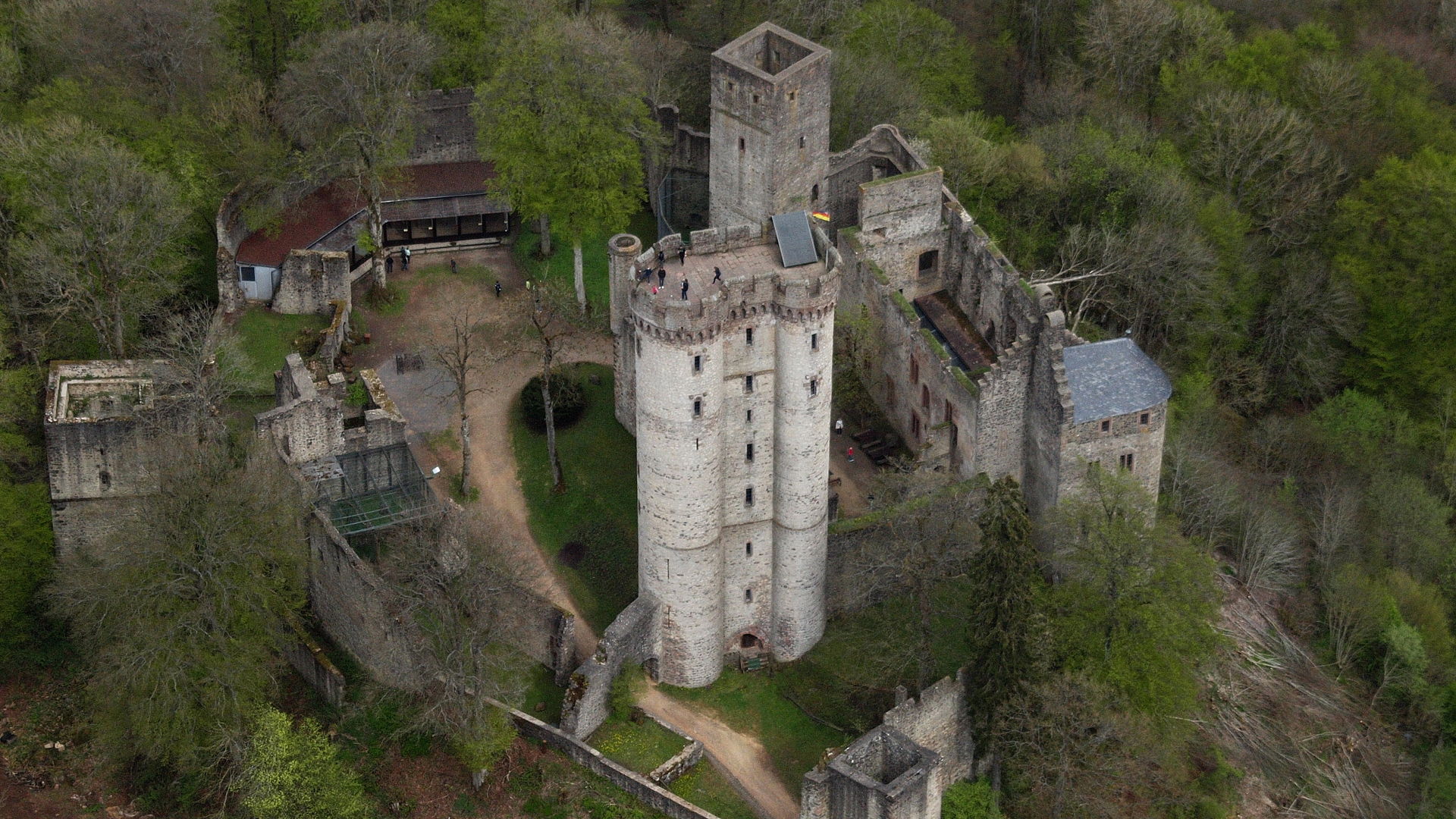
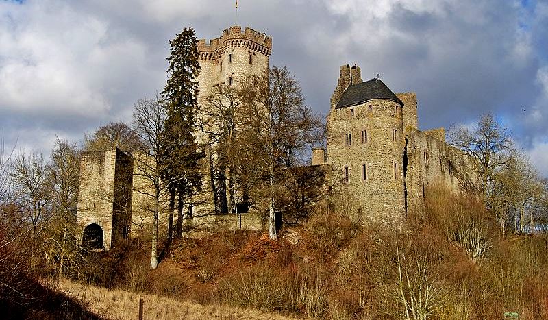
Kasselburg
(MoselcountyBürgermeister1 Photo)
Perm: Kasselburg is a ruined hill castle on a 490-metre-high basalt massif in Pelm near Gerolstein in the county of Vulkaneifel in the German state of Rhineland-Palatinate. The Kasselburg’s 37-metre-high, double tower, functioned as a gate tower and tower house. Its origins are not precisely clear. Up until the present day, it had been assumed that the lords of Blankenheim had built it shortly after 1335. Structural investigations, however, have shown that the tower underwent several phases of construction and is not just the work of one architect. The gate probably lost its guarding function with the expansion of the castle from 1452. YThe large outer bailey, with its burgmann houses and domestic buildings, date from that period.
The double tower is open to the public and has a good view of the surrounding area but, despite its size, is not a bergfried (fighting tower). The latter, built around 1200, is smaller and stands in the eastern part of the inner bailey. It has a square ground plan and was turned into a tower house in the 14th century. A nearly 33-metre-long palas, which dates to the 14th century is part of the inner court. The castle was built in the 12th century. Its owners may have been the lords of Castel, but this is not entirely certain. The castle was first mentioned in 1291 as the Castilburg. In 1314, it is called Castelberch.
The owners prior to 1335 are unknown, although Gerhard V of Blankenheim became its owner following a division of inheritance in that year and thus founded the Blankenheim-Kasselburg line. In 1406, this line of Blankenheims, which had been elevated to the countship, died out with Count Gerhard VII. The castle then passed by marriage to William I of Loen and thus to Heinsberg. Other owners followed, including the Counts of the Mark, Dukes of Arenberg Prince-Electors of Trier. Many special interest groups have claimed the Kasselburg for themselves throughout history, so that in 1674 the Imperial Chamber Court of Wetzlar was called upon to put an end to the property disputes. When the judges awarded the castle to the dukes of Arenberg, the buildings soon served as barracks for the Duke of Arenberg’s artillery troops. This marked the beginning of the decline of the castle. In the 18th century it was still temporarily the seat of an Arenberg forester, but by 1744 it was described as dilapidated.
After France seized the castle in 1794, it went to the Prussians in 1815. An impulse to rescue the ruin came unexpectedly from King Frederick William IV in 1838. After a visit he initiated repair work, and after the completion of the railway line from Cologne to Trier, the railway company donated 1,000 talers to open up the then already famous double tower in order to offer its passengers a view. At the beginning of the 20th century, the state historic preservation authorities carried out further restoration. The Castle Administration of Rhineland-Palatinate, who took over Kasselburg in 1946, also had conservation measures carried out. In the meantime, the site has been placed under the care of the Directorate for Castles, Palaces and Ancient Monuments of the General Directorate for Cultural Heritage Rhineland-Palatinate, since 1998 the successors to the former Castle Administration. (Michael Losse: Kasselburg. Beitrag in: Hohe Eifel und Ahrtal (Joachim Zeune (ed.)). Konrad Theiss Verlag, Stuttgart, 2003)
(Wolfenkratzer Photo)
Kasselburg, aerial view.
(Wolfenkratzer Photo)
Kasselburg, aerial view.
(Felix König Photo)
Kasselburg.
(Pascal Dihe Photo)
Kasselburg.
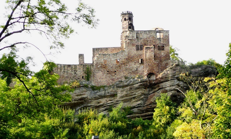
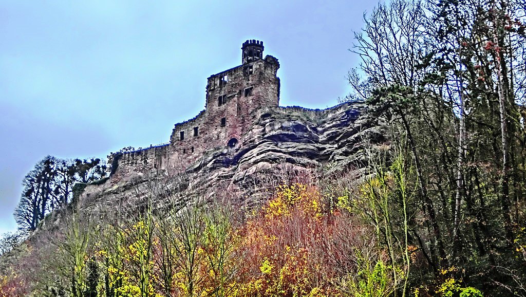
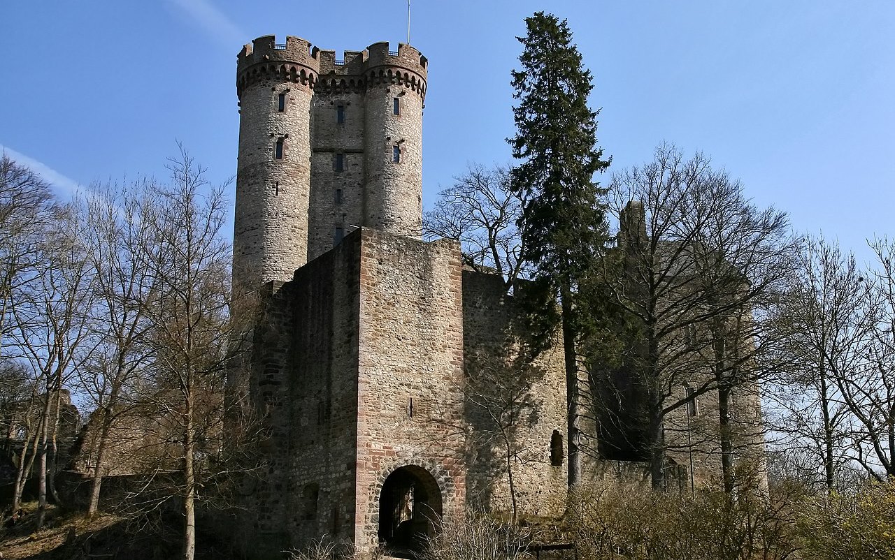
Festung Königstein
(Johannes Robalotoff Photo)
Königstein: Festung Königstein im Taunus. The castle Königstein is part of the Hessian town of the same name in Hochtaunuskreis in Hess. It is one of the largest castle ruins in Germany, standing 407 m above sea level on the western edge of the old town of Königstein. The north and west slopes of the castle hill are forested, further to the west there are undeveloped landscape areas. The Falkenstein Castle ruins are in the northeast, about 1.5 kilometers as the crow flies, and Kronberg Castle lies to the southeast, about 4 kilometers as the crow flies.
There is a legend that King Clovis came (c4th to 5th Century) to this castle site and a virgin appeared who convinced him to become a Christian. After he became one, he founded a castle there, although none of this is documented. The oldest building remains on the castle hill from an older settlement date from the 10th or 11th century. The oldest parts of the inner castle, the so-called herringbone masonry, dates to the first half of the 12th century. The Nürings, who died out in 1172, were the possible builders. After the end of the Staufer period, the castle underwent an energetic expansion under the Falkensteiners. The lower floors of the keep date from the first decades of the 14th century. It has been raised several times over the years and is now 34 meters high. The castle served, especially from the beginning of the 14th century, to protect the important trade route between Frankfurt and Cologne.
The castle has been rebuilt and expanded many times over the centuries. In addition to the adaptation to the developing defence technology, the expansion into a Renaissance-era residential palace for the count of Königstein was promoted. In the 16th century, Count Eberhard IV von Eppstein and Ludwig zu Stolberg built the three mighty rondelles on the eastern flank, as well as the façade on the eastern side of the inner castle. When the count family died out, the castle fell to the Electorate of Mainz in 1581, when it was used for military purposes. Archbishop Johann Philipp von Schönborn initiated the last major expansion phase between 1660 and 1670, including the angular bastions on the south side.
In the First Coalition War, the French army under Custin, took Mainz on 21 October 1792 , and a few days later Königstein. After the reconquest of Frankfurt on 2 December by Prussian troops, part of the French forces withdrew to the Königstein Fortress, closely followed by the Prussians under the orders of General Friedrich Ludwig zu Hohenlohe. Hohenlohe occupied Oberursel, Falkenstein Castle, the city of Koenigstein and began bombarding the fortress from Falkenstein on 6 December. On 8 December, bombs thrown into it (the origin of which remains unclear) caused a fire in the city, which destroyed 80% of the houses. Since the fortress did not surrender even after being bombarded, it was enclosed. On 8 March 1793, the defenders finally surrendered. The 421 men and 14 officers captured were brought to the Ehrenbreitstein fortress. In 1793 clubists, actual or supposed supporters of the Mainz Republic, were imprisoned in the cellars of Mainz Castle, among them Caroline Böhmer, who later became the “Romantic Museum” Caroline Schelling.
During the coalition war, the castle was severely damaged in 1796, mainly due to a failed attempt at demolition. The destruction seen to day is likely to be largely due to the Königstein population, who obtained building materials for numerous houses in the present old town after 1796. The Duke of Nassau, to whom the castle fell after the Reichsdeputationshaupschluss, decided against rebuilding and allowed the demolition to continue for another twenty years.
While the sovereignty of Königstein passed to Prussia in 1866, the castle remained the private property of Duke Adolph, who later became the Grand Duke of Luxembourg. He built his own small castle (today Königstein District Court) at the foot of the mountain (southeast corner). His daughter, Hilda von Nassau, gave the fortress ruins to the city of Königstein in 1922.
The castle, which is now owned by the city of Königstein, is open to visitors all year round. Both the castle tower and most of the cellars are accessible. One of the preserved vaulted cellars (the armoury cellars ) can also be rented for private events. In the old town of Königstein there is a castle museum with finds and a model of the castle. (Fortresses in Hessen. Published by the German Society for Fortress Research eV, Wesel, Schnell and Steiner, Regensburg 2013)
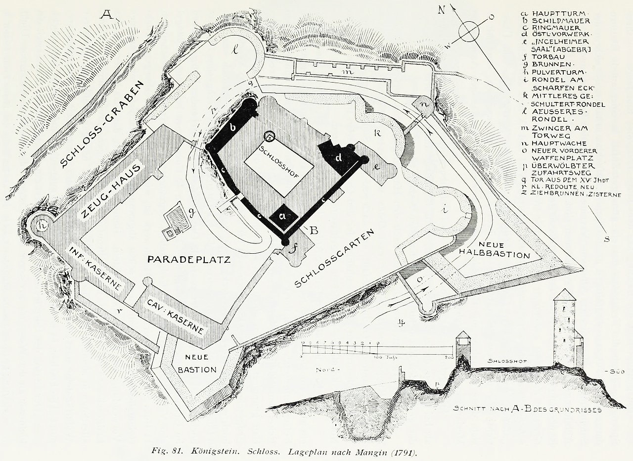
Festung Königstein ground plan.
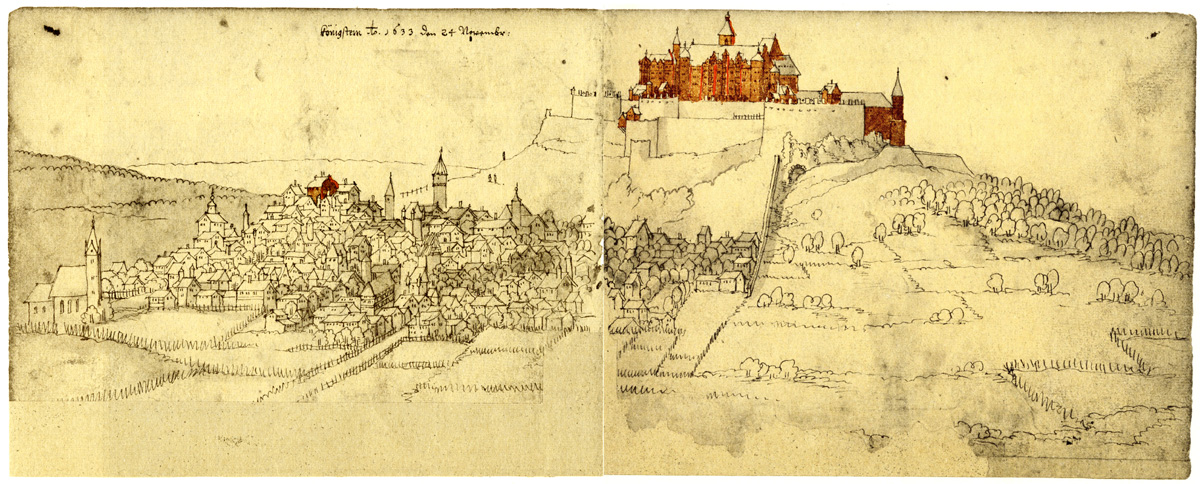
Königstein, view from the northeast, 1633.
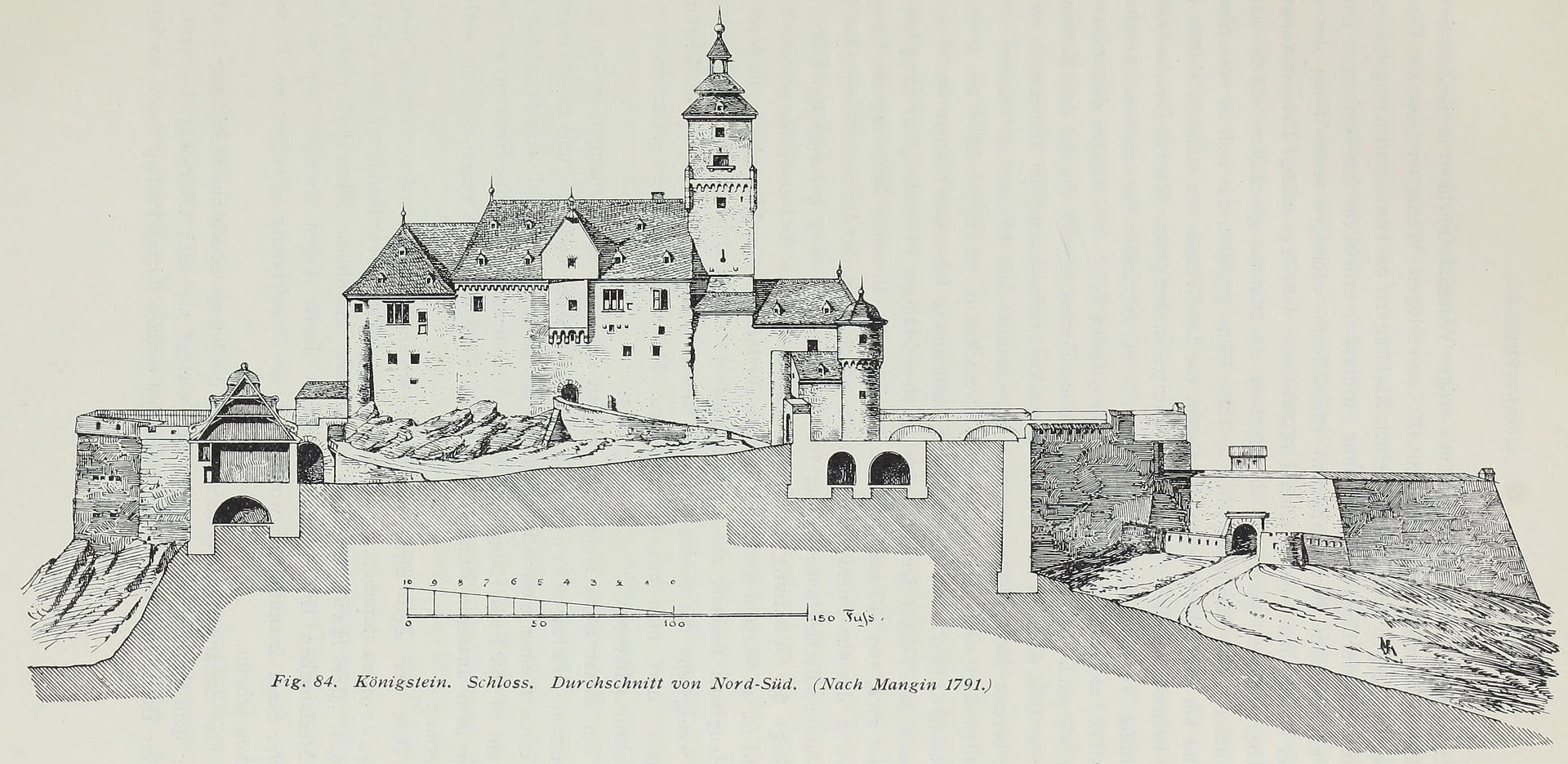
Königstein, profile view from the northeast, 1791.
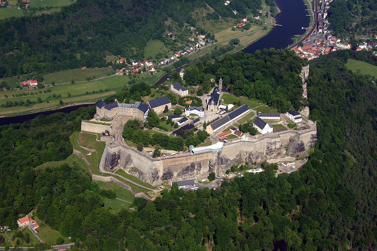
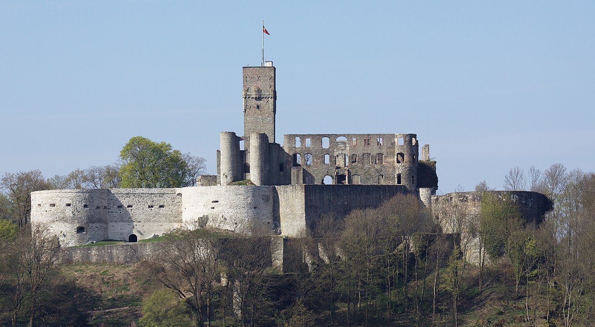
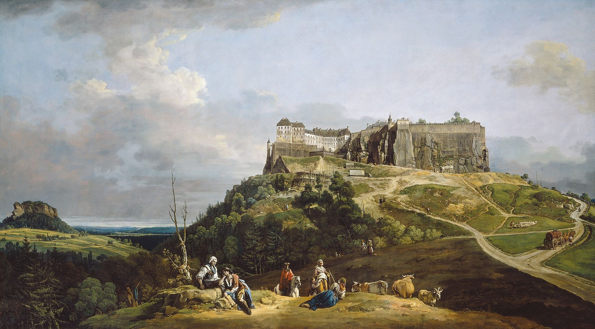
(Fritz-Gerald Schröder Photo)
Königstein: Festung Königstein also known as the Saxon Bastille stands above the town of Königstein near Dresden in Saxon Switzerland, on the left bank of the River Elbe. It is one of the largest hilltop fortifications in Europe and sits atop the table hill of the same name. The 9.5 hectare rock plateau rises 240 metres above the Elbe and has over 50 buildings, some over 400 years old, that bear witness to the military and civilian life in the fortress. The rampart run of the fortress is 1,800 metres long with walls up to 42 metres high and steep sandstone faces. In the centre of the site is a 152.5 metre deep well, which is the deepest in Saxony and second deepest well in Europe. The fortress, which for centuries was used as a state prison, is still intact and is now one of Saxony’s foremost tourist attractions, with 700,000 visitors per year.
By far the oldest written record of a castle on the Königstein is found in a deed by King Wenceslas I of Bohemia, dating to the year 1233, in which a witness is named as “Burgrave Gebhard of Stein”. At that time the region was split between the Kingdom of Bohemia and the Bishopric of Meissen. The medieval castle belonged to the Kingdom of Bohemia. Its first full description as Königstein (“King’s Rock”) occurred in the Upper Lusatian Border Charter (Oberlausitzer Grenzurkunde) of 1241, that Wenceslas I “in lapide regis” (Lat.: at the rock of the king) sealed. In this charter the demarcation of the border between the Slavic Gauen of Milska (Upper Lusatia), Nisani (Meißen Depression) and Dacena (Tetschen region) was laid down. Because the Königstein lay left of the Elbe, it was independent of the three aforementioned Gauen.
The fortress was expanded by order of the Bohemian kings, into a fortified site that dominated the north of their territories, controlling the Elbe above Pirna. As the Elbe became more intensively used as a trade route, and an outpost of the strategically important Dohna Castle located in nearby Müglitz. After the king and later emperor, Charles IV had Eulau Castle, which dominated the southern region, destroyed in 1348 by townsfolk from Aussig, he spent from 5 to 19 August 1359 on the Königstein and signed the authority for shipping rights. The castle was pledged several times in the 50 years that followed, including to the Donins. Because this family were enemies of the margraves of Meißen, the latter finally captured the castle in 1408 during the Dohna Feud that had been raging since 1385. The transfer of ownership of the castle to the Margraviate of Meißen did not take place until 25 April 1459. It was finally completed once the Saxon-Bohemian border had been settled in the Treaty of Eger. Unlike the other rock castles in Saxon Switzerland the Königstein continued to be used by the Saxon dukes and prince-electors for military purposes. At one stage the Königstein was also a monastery. In 1516, Duke George the Bearded, a fierce opponent of the Reformation, founded a Celestine abbey on the Königstein, the Kloster des Lobes der Wunder Mariae. It closed again in 1524, and after the death of Duke George, Saxony became Evangelical.
It is likely that there had been a stone castle on the Königstein as early as the 12th century. The oldest surviving structure today is the castle chapel built at the turn of the 13th century. In the years 1563 to 1569 the 152.5 metre deep well was bored into the rock within the castle. Up until that point, the garrison of the Königstein had to obtain water from cisterns and by collecting rainwater. During the construction of the well some 8 cubic metres of water had to be removed from the shaft every day.
Between 1589 and 1591/97 Prince-Elector Christian I of Saxony and his successor had the castle developed into the strongest fortification in Saxony. The hitherto very jagged table hill was now surrounded with high walls. Buildings were erected, including the Gatehouse (Torhaus), the Streichwehr, the Old Barracks (Alte Kaserne), the Christiansburg (Friedrichsburg) and the Old Armoury (Altes Zeughaus). The second construction period followed from 1619 to 1681, during which inter alia the John George Bastion (Johann-Georgenbastion) was built in front of the Johann-Georgenburg.
The third construction period is seen as the time from 1694 to 1756, which included the expansion of the Old Barracks. From 1722 to 1725, at the behest of August the Strong, coopers under Böttger built the enormous Königstein Wine Barrel (Königsteiner Weinfass), the greatest wine barrel in the world, in the cellar of the Magdalenenburg which had a capacity of 249,838 litres. It cost 8,230 thalers, 18 groschen and 9 pfennigs. The butt, which was once completely filled with country wine from the Meißen vineyards, had to be removed again in 1818 due to its poor condition.
Because of Böttger, Königstein Fortress is also the site where European porcelain started. Even after the expansion during those periods of time there continued to be modifications and additions on the extensive plateau. St. John’s Hall (Johannissaal) built in 1631 was converted in 1816 into the New Armoury (Neues Zeughaus).
In 1819 the Magdalenenburg castle was turned into a provisions magazine that was fortified to withstand bombardment. The old provisions store became a barracks. The Treasury (Schatzhaus) was built from 1854 to 1855. After the fortress had been incorporated in 1871 into the fortification system of the new German Empire, battery ramparts (Batteriewälle) were constructed from 1870 to 1895 with eight firing points, that were to have provided all-round defence for the fortress in case of an attack that, in the event, never came. This was at this time that the last major building work was done on the fortress.
Because Königstein Fortress was regarded as unconquerable, the Saxon monarchs retreated to it from Wittenberg and later Dresden during times of crisis and also deposited the state treasure and many works of art from the famous Zwinger there. It was also used as a country retreat due to its lovely surroundings. The fortress played an important role in the History of Saxony, albeit less as a result of military action. The Saxon Dukes and Prince-Electors used the fortress primarily as a secure refuge during times of war, as a hunting lodge and maison de plaisance, but also as a dreaded state prison. Its actual military significance was rather marginal, although generals such as John Everard of Droste and Zützen (1662–1726) commanded it. For example, Prince-Elector Frederick Augustus II could only watch helplessly from the Königstein during the Seven Years’ War, when right at the start of the war in 1756 his army surrendered without a fight to the Prussian Army at the foot of the Lilienstein on the other side of the Elbe. The commandant of the fortress from 1753 was the electoral Saxon Lieutenant General, Michael Lorenz von Pirch. In August 1813 the clash at Krietzschwitz took place in front of its gates, an engagement that proved an important precursor to the Battle of Kulm and the Battle of Leipzig. In October 1866 Alexander von Rohrscheidt (1808–1881) was nominated as commandant of the fortress. It lost its military value with the development of long-range guns at the beginning of the 19th century. The last commandant of Königstein Fortress was Lieutenant Colonel Heinicke who commanded it until 1913. The fortress had to guard the Saxon state reserves and secret archives during times of war. In 1756 and 1813 Dresden’s art treasures were also stored at the Königstein. During the Second World War the large casemates of the fortress were also used for such purposes.
The fortress was never conquered, it had too much of a chilling reputation after it had been expanded by Elector Christian I. Only the chimney sweep, Sebastian Abratzky, managed to climb the vertical sandstone walls in 1848. The Abratzky Chimney (Abratzky-Kamin) named after him is a grade IV (based on the Saxonsystem) climbing route that may still be climbed today. Because climbing over the wall is banned, climbers must abseil down the adjacent wall again after climbing it.
Until 1922 the fortress was the best-known state prison in Saxony. During the Franco-Prussian War and the two world wars the fortress was also used as a prisoner of war (PW) camp. In the First World War, the castle was used as a PW camp (Oflag) for French and Russian officers. In the Second World War it again served as an Oflag (Oflag IV-B), for British, French, Polish and other Allied officers.
After the Second World War the Red Army used the fortress as a military hospital. From 1949 to 1955 it was used as a so-called Jugendwerkhof for the re-education of delinquent youths and those who did not fit the image of a socialist society. Since 29 May 1955, the fortress has been an open-air, military history museum of high touristic value. The museum has been managed as a satellite of the Bundeswehr Military History Museum in Dresden since 1990. (Immer weniger Besucher in Festung Königstein, Freie Presse dated 10 February 2011)
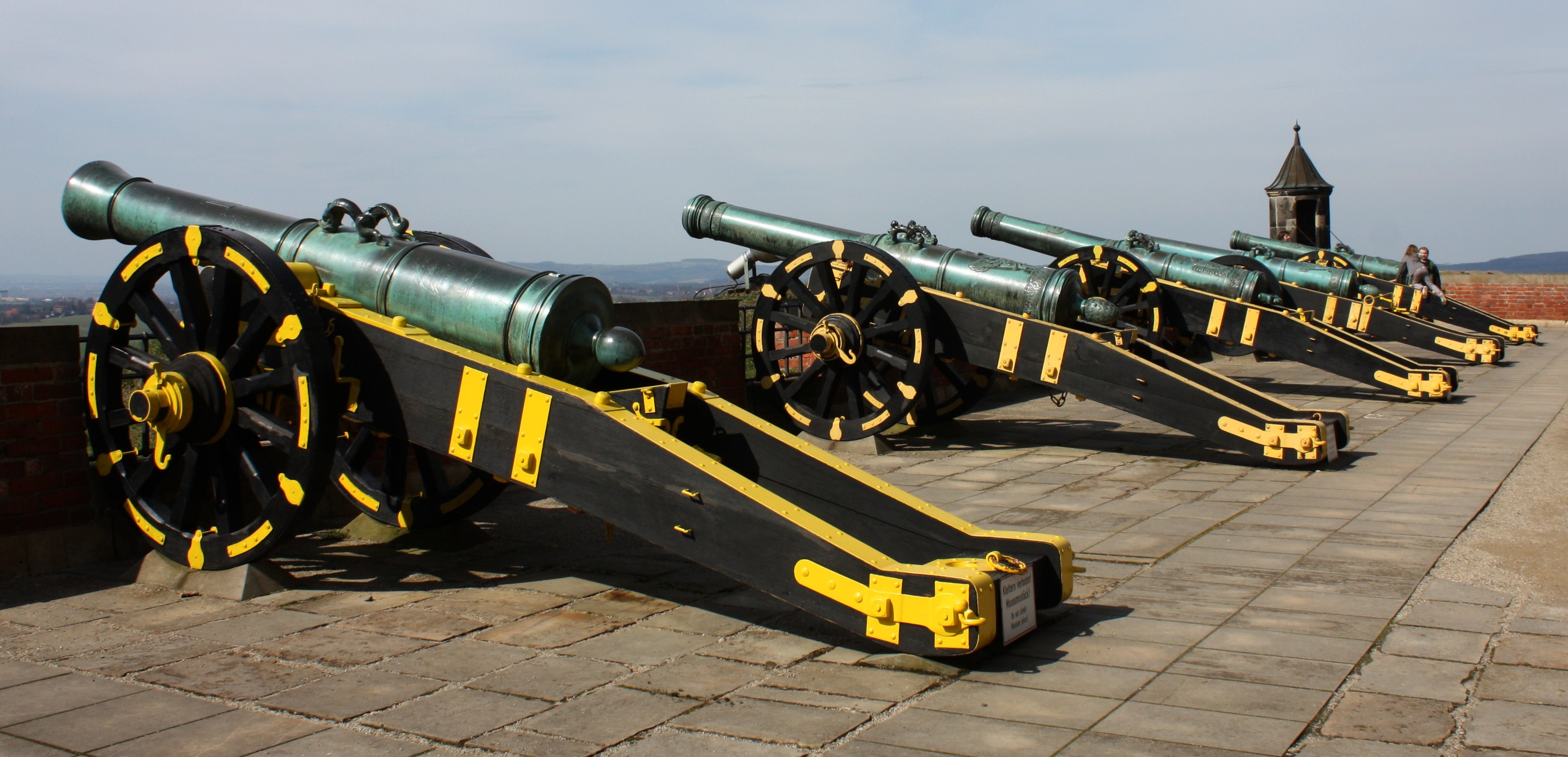
(Reneman Photo)
Quarter cannons on gun carriages. Kartouwes in front of the John George Bastion on the Königstein Fortress.
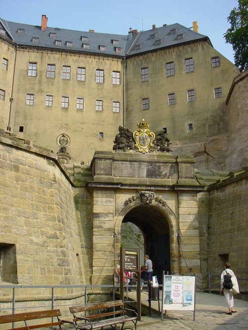
(Reinhard Kraasch Photo)
Festung Königstein, entrance.
The Fortress of Königstein from the North-West (Benarto Bellotto, National Gallery of Art, Washington)
Burg Lauf
(Rainer Lippert Photo)
Lauf an der Pegnitz: Burg Lauf (Wenzelschloss), was originally a medieval fortress in the town of Lauf an der Pegnitz near Nürnberg. The German name Wenzelschloss (“Saint Wenceslas’ Chateau”) is derived from the statue of Saint Wenceslas, on the facade of the entrance gate. The castle was built by the Holy Roman Emperor, Charles IV in 1356, on the ruins of an older castle. The dominant feature of the castle is the hall of arms. In 1934, under a layer of old paint 112 coats of arms of noblemen of the Crown of Bohemia were discovered. It is a significant collection of Bohemian, Moravian and Silesian secular and ecclesiastical heraldry.
Lauf stands in an area called the Bohemian Palatinate, which was once part of the Bohemian crown lands. In 1373 Emperor Charles IV ceded the castle along with parts of the Bohemian Palatinate to Otto V, Duke of Bavaria in exchange for the Margraviate of Brandenburg. Charles’ son Wenceslaus IV lost the rest of the Palatinate in 1401.
(Krzysztof Photo)
Wenceslas Castle with wooden footbridge.
Burg Lichtenberg
(LoKiLeCh Photo)
Thallichtenberg: Burg Lichtenberg is a ruin of a spur castle, with a length of 425m (1,394 ft), marking it as the largest castle ruin in Germany. It is located in the district of Kusel in the Rhineland-Palatinate. The castle was built around 1200 and was owned until 1444 by the counts of Veldenz; after which it fell into the ownership of the new dukedom of Palatinate-Zweibrücken. Under the new rule, Burg Lichtenberg became the administrative seat of Zweibrücken until the move of the administration to Kusel in 1758. The castle remained under the duchy until the dissolution of the Duchy of Zweibrücken in 1792.
This part of Germany west of the Rhine river was occupied by French Revolution troops in 1792, and in 1795, the French dissolved the old borders and created new administrative districts, placing Lichtenberg Castle in the Saar Department. The town of Kusel was burnt down by French revolution troops in 1794. Lichtenberg Castle was plundered numerous times during the ensuing chaos that came with the French occupation, and in 1799, a fire caused by the castle’s inhabitants destroyed much of the castle.
With the defeat of French Emperor Napoleon Bonaparte and the subsequent withdrawal of French troops from Germany, in 1816 the area west of the Rhine was given to the Duke of Saxony-Coburg-Gotha and became the Princedom of Lichtenberg. Tthis rule was short-lived, and in 1834 the princedom was sold to Prussia. Lichtenberg Castle fell into disrepair and ruin until, in 1895, the whole castle complex was placed under historical monument protection. At the end of the Second World War, the Prussian government fell, and in 1945 the district of Birkenfeld, in which Lichtenberg Castle lay, became a part of the new state of Rhineland-Palatinate. In 1971 the castle was handed over by Rhineland-Palatinate to the district of Kusel, and restoration work began. Some of the restorations include the reconstruction of the tithe barn and the repair and roofing of the bergfried.
The horseshoe tower has been the meeting place for the University of Kaiserslautern since 1987. The tower on the southeast corner of the official administrative office also houses a restaurant, the Knight’s Hall, and in the administrative office building extension, a youth hostel. In the lower bailey is a church that still conducts services for the parish of Thallichtenberg. From the bergfried, one can see the Remigiusberg monastery church and ruins of the nearby Michelsburg castle, as well as the Potzberg hill. (Visited 26 March 1983)
(Triodus23 Photo)
Burg Lichtenberg.
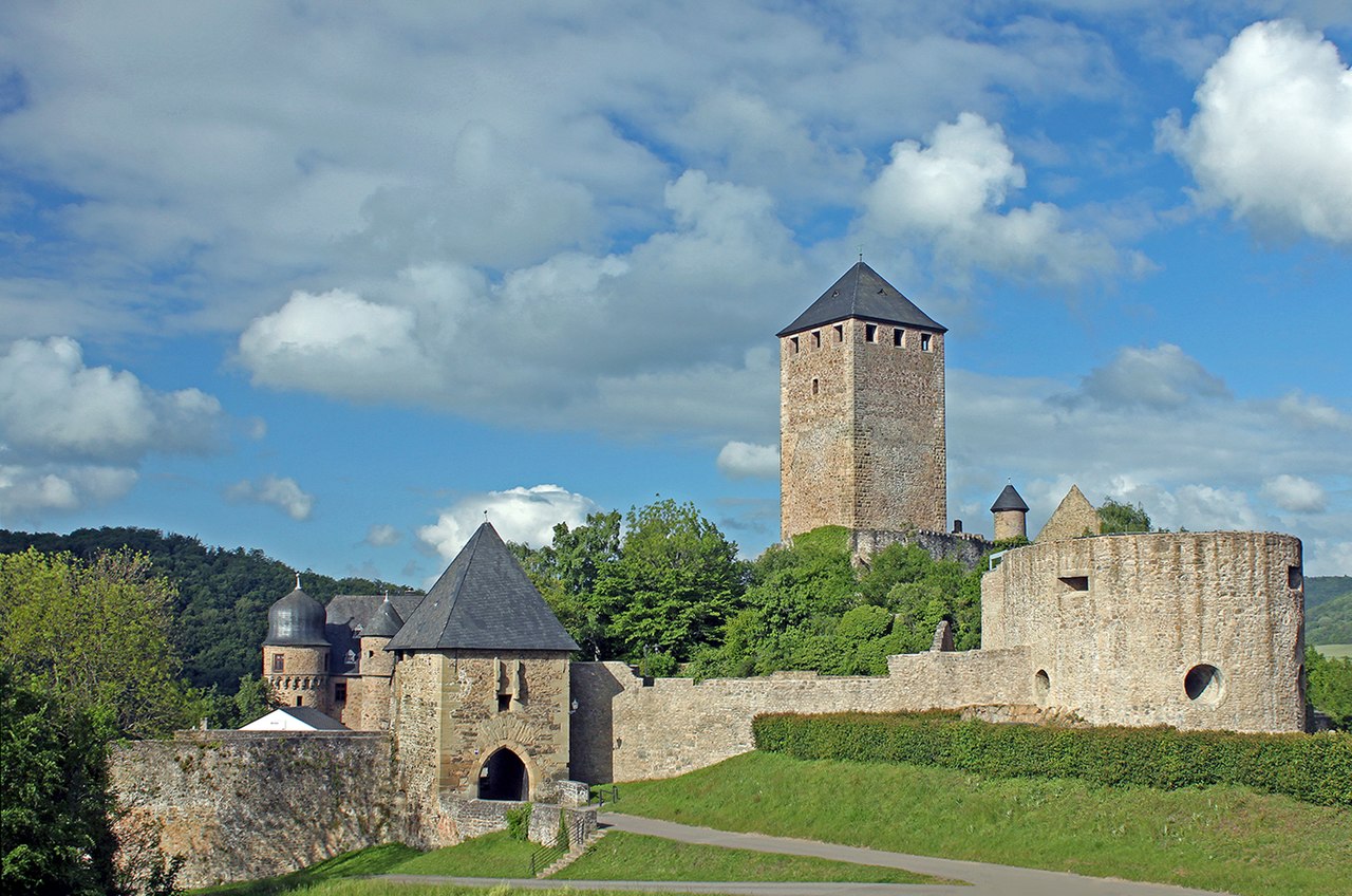
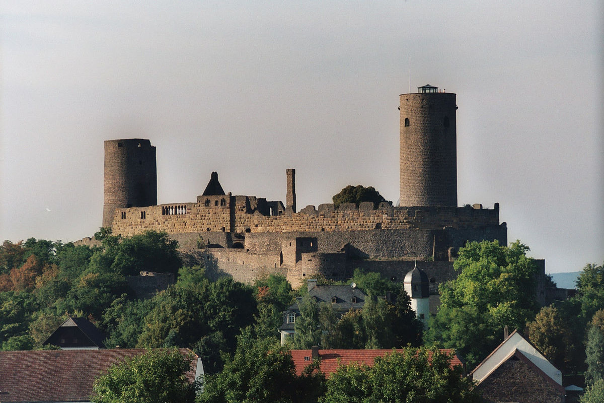
Burg Münzenberg
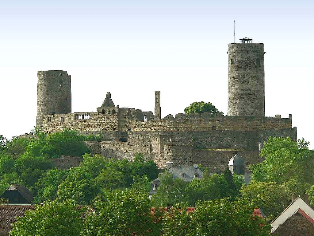
(Presse03 Photo)
Münzenberg: Burg Münzenberg is a ruined hill castle in the Wetteraukreis, Hesse. It dates from the 12th century, and is one of the best preserved castles from the High Middle Ages in Germany. The first lord of nearby Arnsburg, Kuno von Arnsburg, served Emperor Heinrich IV as a Ministerialis in 1057. c1064 he married Gräfin Mathilde of the House of Bilstein. Their daughter, Gertrud (b. c1065, d. before 1093) married Eberhard von Hagen (1075-1122), lord of Burg Hayn near Frankfurt, who moved his seat to Arnsburg and changed his name to “von Hagen und Arnsburg”. Under Eberhard’s son, Konrad I (1093-1130) the family became the most powerful in the Wetterau and the Rhine-Main region. Konrad II exchanged properties with Fulda Abbey, receiving the land around Münzenberg Castle. His son, Kuno I (1151-1207), from 1156 styled himself von Münzenberg, implying that by then a castle had been built at Münzenberg and the earlier one at Arnsburg had been vacated.
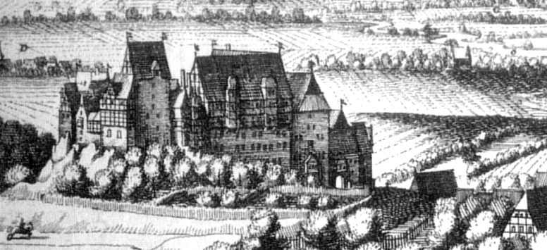
A striking feature of Münzenberg Castle is that it has two tall bergfried defensive towers. Such a tower is a typical feature of castles in the region, but there is usually only one, forming the strongest point of the castle. The bergfrieds at Münzenberg are both round, the taller one being 29 meters high. The two bergfrieds stand at opposite ends of the inner ward, called the Kernburg. The inner ward is completely surrounded by an outer ward with an outer curtain wall, providing defence in depth. (Gärtner, Otto (1998). Kloster Arnsburg in der Wetterau (German). Verlag Karl Robert Langewiescher Nachfolger Hans Köster KG)
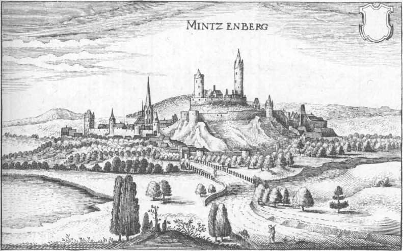
Münzenberg (Mintzenberg), Topographia Hassiae, Matthäus Merian, 1655.
(Johannes Robalotoff Photo)
Burg Münzenberg.
(Johannes Robalotoff Photo)
Burg Münzenberg.
(Carsten Steger Photo)
Burg Münzenberg.
Burg Neuleiningen
(Immanuel Giel Photo)
Neuleiningen: Burg Neuleiningen is a castle ruin on the eastern edge of the Palatinate Forest in the state of Rhineland-Palatinate in the Bad Dürkheim district. It was built in 1238-41 by Count Frederick III of Leiningen. The French destroyed it in 1690 and it has lain in ruins since that time. The castle is located on a foothill of the Haardt on the northeastern edge of the Palatinate Forest. Its eponymous village is grouped around the castle, high above the left bank of the Eckbach at an elevation of about 300 metres above sea level. Near the castle is the Old Vicarage (Alte Pfarrey), which was first recorded in 1524 and which houses a gourmet restaurant today.
Its name, like that of its sister castle, Altleiningen five kilometres to the southwest, is derived from the Frankish noble family, the counts of Leiningen who rulled the territory of Leiningerland. The castle was built following a division of inheritance around 1240 by Count Frederick III of Leiningen. Together with, Battenberg Castle, 1,400 metres to the south, the castle controlled the entrance to the Eckbach valley. Passing between various lines of the family, the castle remained the property of the Leiningens for over 200 years. In 1468, Prince-Elector Frederick the Victorious of the Palatinate became involved in inheritance disputes amongst the Leiningens and seized possession of the castle by force. In 1508, after passing through several intermediate arrangements, an agreement was reached: the castle would be divided between the Bishopric of Worls and the counts of Leiningen-Westerburg.
In 1525, during the Peasants’ War, the castle was opened to the rebellious farmers without a fight and, having been hosted by Countess Eva (1481–1543) in a friendly and generous way, the farmers left without causing great damage. The castle only suffered minor damage in the Thirty Years’ War. During the War of the Palatine Succession, however, invading French troops razed the entire site in 1690. Its two owners, Leiningen-Westerburg and the Bishopric of Worms, could not agree to rebuild the castle in the period that followed, with Leiningen being for, and Worms being against, the idea. In 1767, Charles of Leiningen-Westerburg finally sold the Leiningen half to Worms.
In the wake of the French Revolution, the castle ruins were seized by secular authorities and passed in 1804 into the hands of the municipality of Neuleiningen, who, sold it just four years. In 1874, Charles Emich of Leiningen-Westerburg bought it back again for his family. The castle is quadrangular, with a rectangular ground plan and bergfried towers projecting beyond the curtainwalls. Contrary to earlier views, the castle was built to the same pattern as French castles of the early 13th century in the Île-de-France style. Its design was not copied from an existing castle; instead, it combined a French design with local building traditions. Most striking are its four, round towers and the large number of very narrow arrow slits (Schlitzscharten), for archers armed with bows and crossbows. These Schlitzscharten are amongst the earliest examples on German soil. Thus, apart from Lahr Castle, of which little remains, Neuleiningen is the oldest quadrangular castle in Germany.
The internal elements from the first phase of construction have been totally lost and can only be made out here and there from excavations. The present remains date to the 14th to early 17th centuries. The most striking feature of the castle is the stepped gable of the palas on the north side which, in its present guise, goes back to Landgrave Hesso of Leiningen (before 1435–1467). In the southeast corner the cellar of the Leiningen-Westerburg residence of around 1508 has survived. This is where the Burgschänke inn was established in the second half of the 20th century.
Today, the southeast tower is an observation tower that is open to the public. The two upper storeys of this tower have been turned into a small local history museum that exhibits the stoneware products of an old local factory that closed in 1932, as well as other handicrafts. The local village, which is connected to the castle both geographically and historically, was built around the same time (13th century). The village’s historic buildings are fairly numerous, with only a few parallels in the region. From the observation tower of the castle there is an outstanding view of the Upper Rhine Valley to the east, the mountains of the Palatinate Forest to the south and west and the massif of the Donnersberg to the northwest. At the foot of the hill village of Neuleiningen is the hamlet of Neuleiningen-Tal and several neighbouring villages. (Immanuel Giel Photo)
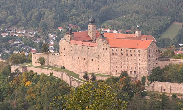
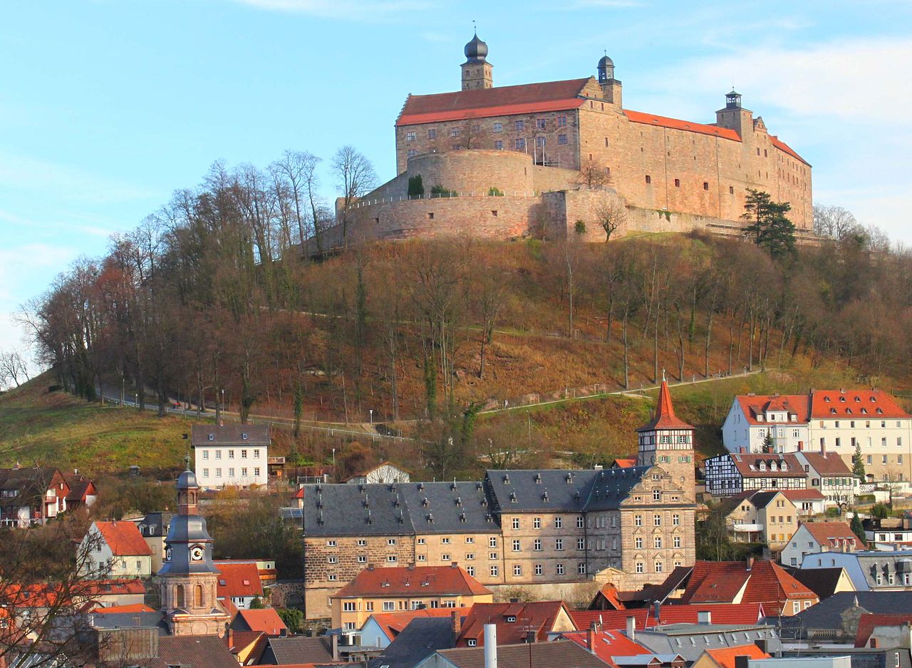
Plassenburg
(El Grafo Photo)
Kulmbach: Plassenburg is an impressive castle in Bavaria, first mentioned in 1135. The Plassenberg family were ministeriales of the counts of Andechs (later the dukes of Andechs-Meranien) and used as their seat the Plassenburg. The House of Guttenberg, a prominent Franconian noble family, traces its origins back to 1149 with a Gundeloh v. Blassenberg (Plassenberg). The name Plassenburg is derived from Guttenberg and was adopted by a Heinrich von Blassenberg around 1310. From 1340, the Hohenzollerns governed their territories in Franconia from the Plassenburg castle until 1604. The Plassenburg was both a fortress and residence for the Hohenzollerns.
It was destroyed in 1554 at the end of the second Margravian War (1552–1554), when it was held by Margrave Albert Alcibiades. The Plassenburg was later rebuilt by the architect Caspar Vischer as an impressive stronghold and as a huge palace. In 1792, Margrave Alexander sold the Plassenburg to his cousin, the King of Prussia. A combined Bavarian and French army under the command of Jérôme Bonaparte, brother of Napoleon, besieged the Plassenburg in 1806. In 1810, Kulmbach became Bavarian and the castle was used as a prison and as a military hospital. During the Second World War, the Organization Todt used the Plassenburg as a training camp and recreation home. Today, it is a museum and a venue for cultural events. It contains a significant collection of Prussian military artifacts and portraits.
Plassenburg Castle was first mentioned in 1135, when it was described by Count Berthold II of Andechs as comes de Plassenberch. Presumably he was also the founder of the castle, which was built to the west of an earlier fortified farmstead. To begin with, the castle was a central supporting stronghold for the Meranian rulers of the Upper Main and Franconian Forest. After the death of the last Andechs-Meranian, Duke Otto VIII, his brother-in-law divided his inheritance. Plassenburg Castle, along with Kulmbach, Berneck, Goldkronach, Wirsberg, Trebgast, and Pretzendorf (now Himmelkron) went to Herman III and Otto III, the Counts of Weimar-Orlamünde. The two sons of Herman II (died 1247) and Beatrix of Andechs-Merania initially ruled together as “Lords of Plassenburg”. After 1278 they divided the inheritance of their father, whereupon Otto III was given sole possession of the domain of Plassenburg and the territory around Weimar.
Otto III died in 1285 and the Plassenburg appeared soon afterwards in the hands of his son Otto IV. His son in turn, Count Otto VI of Orlamünde, who was the only Orlamünde since 1323 who was described as “Lord of Plassenburg”, pledged this lordship together with the Plassenburg, Kulmbach, Trebgast and Berneck in 1338 to Burgrave John II of Nürnberg. As a result, after Otto VI’s death in 1340, Plassenburg fell to the Burgraves of Nürnberg from the House of Hohenzollern.
Gradually, Plassenburg Castle developed into a new centre of power for the Hohenzollerns. At the time of Burgrave Frederick V of Nürnberg (who reigned 1357–1397), the Plassenburg had already outstripped the Cadolzburg, which was a traditional burgravial residence. In 1397 Burgrave Frederick V stepped down from the business of government and chose the Plassenburg as his retirement home. The Hohenzollerns’ territory in Franconia was divided between his sons, John III and Frederick VI, later to be the Elector of Brandenburg, in accordance with the Dispositio Fridericiana of 1385. Thus, the Plassenburg became the centre of power for the so-called Principality of the Mountains (Fürstentum ob dem Gebirg), later the Margraviate of Brandenburg-Kulmbach. After the death of John III in 1420, his estate fell to his brother, Frederick, who, in 1421, created the office of “Captain of the Mountains” to rule his domain. Plassenburg remained the administrative centre of this hilly principality until after the middle of the 16th century.
The imprisonment of the Countess Barbara of Brandenburg in March 1493, began the sad chapter of Plassenburg Castle as a family prison. This reached a peak in February 1515 when Margrave Casimir of Brandenburg-Kulmbach locked up his father, Margrave Frederick I of Brandenburg-Ansbach, in a tower room at Plassenburg from which he could not leave for 12 years. In 1542, Margrave Albert II of Brandenburg-Kulmbach moved the Residenz of the Margraves of Brandenburg-Kulmbach for the first time from Plassenburg, which continued to serve primarily as a country fortress to Bayreuth from then on. (Wolfgang Schoberth, Doris Leithner: Text und Kommentar zu, Die Gefangenen auf der Plassenburg“. Reihe: Buchners Schulbibliothek der Moderne, H. 22. Buchner, Bamberg 2005)
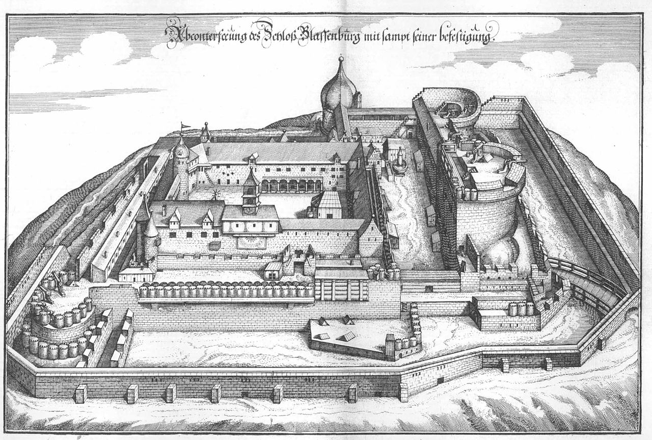
Plassenburg, engraving, Mattäus Merian, 1656.
(Benreis Photo)
Plassenburg.
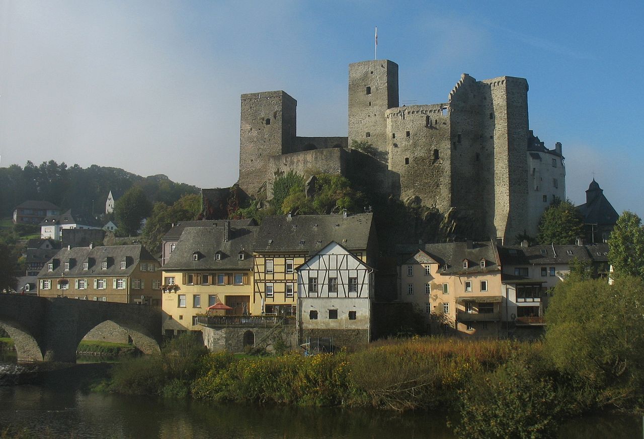
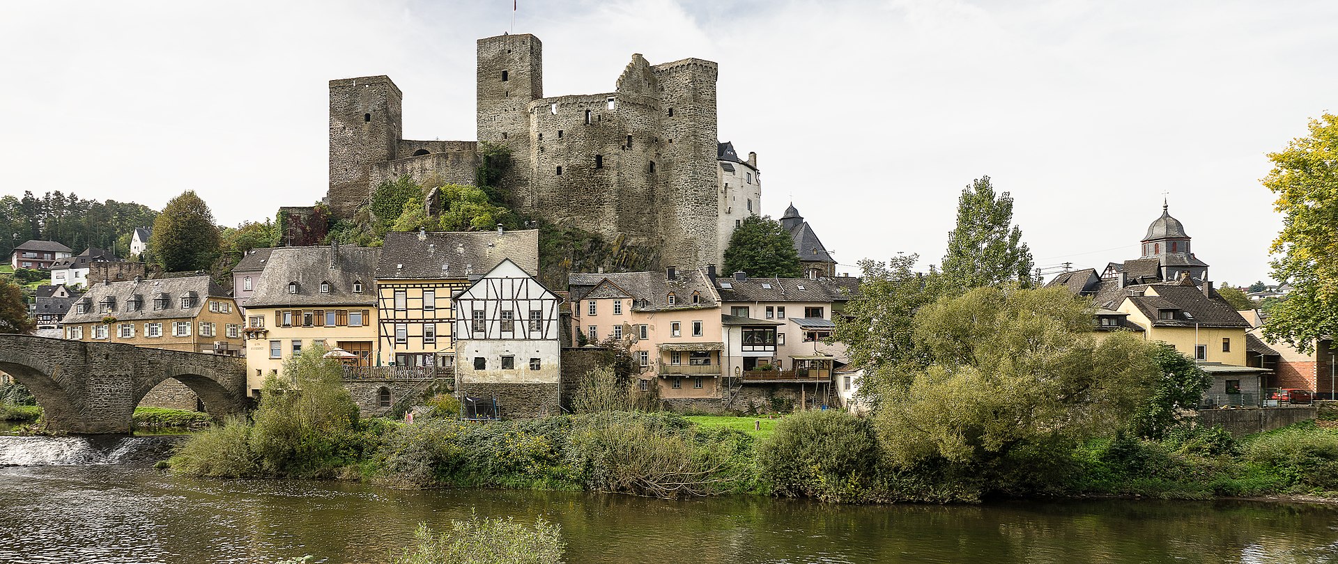
Burg Runkel
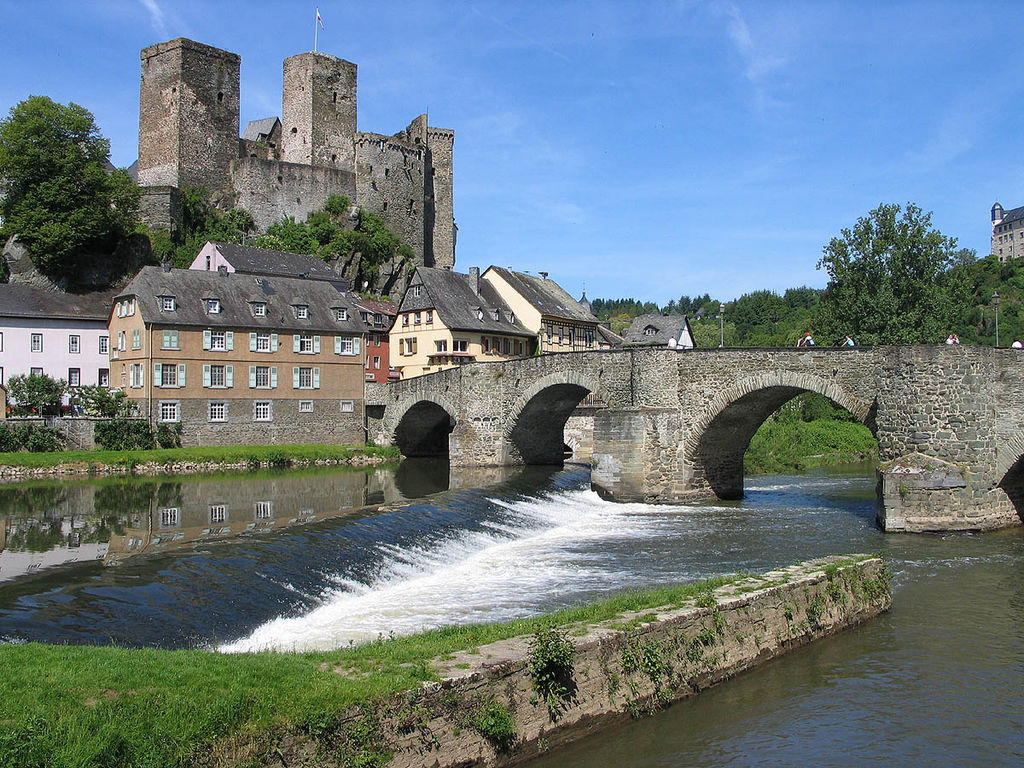
(Luidger Photo)
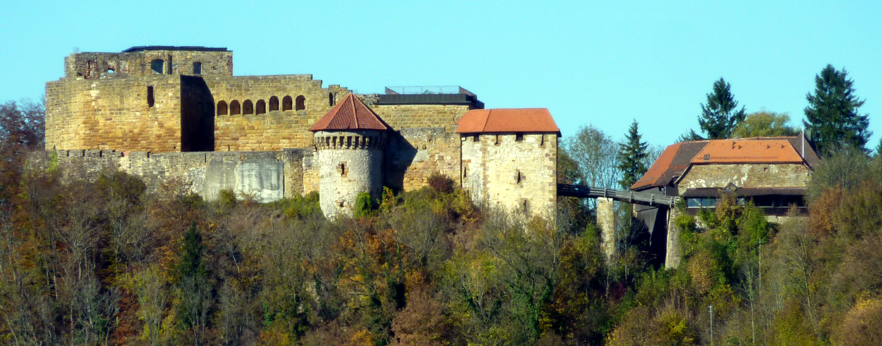
Runkel: Burg Runkel is a ruined hill castle dating from the High Middle Ages, located in the city of Runkel in the Landkreis (District) of Limburg-Weilburg in the state of Hesse. Nestled in the valley of the Lahn River, the town and castle are, i 3.75 mi (6.04 km) east of Limburg an der Lahn, 18.6 mi (29.9 km). The hill fort is situated at 492 ft (150 m) above sea level and rises about 115 ft (35 m) to 131 ft (40 m) above the valley of the Lahn.
“Run – kall” is the Celtic word for a rock mountain, and as the hill had already attracted their attention, they may have given it its name. In 1159, Sigfridus de Runkel was mentioned in documents, but the castle had been built a little earlier by a man with the same name, probably on the orders of the Holy Roman Emperor, Frederick Barbarossa. It served to protect the strategic pass between Weilburg and the southern side of the region. At the time of the castle was built, there was just a ferry. The bridge was not built until the Late Middle Ages.
Around 1250, a dispute over the sale and inheritance of the property arose between Siegfried V von Runkle and his cousin, Heinrich (died 1288). In 1276, as a result of their quarrel, the cousin was driven from the castle. He moved to the other side of the Lahn River, where he built the Schadeck Castle as Trutzburg and created the Westerberg line. Dietrich III von Runkel enlarged his Herrschaft in 1376 to the Zehnten ( tithing districts) of Schupbach and Aumenau and built a more modern castle next to the original building. Dietrich IV (died after 1462), gained the Grafschaft of Wied, by marrying Anastasia the Wied-Isenburg heiress, which began the Wied-Runkel line and increased his influence in the region. In 1440, the building of the stone bridge over the Lahn River was commissioned but, because of a dispute over the proceeds from the duties and tolls, it was not finished until 1448. In 1543 Philipp Melanchthon, a Protestant reformer, visited the castle as the guest of Count Johann IV von Wied-Runkel (died 1581), the nephew of the Archbishop of Cologne, Hermann of Wied.
In 1595, a new dispute began over the castle, this time between the two lines, Wied-Isenburg and Wied-Runkel, and the County of Wied was divided between them. Wilhelm IV von Wied-Runkel was given the “Obere Grafschaft Wied” (Upper County of Wied), including Runkel and Dierdorf, while his nephew Johann Wilhelm von Wied Runkel was left with the “Niedere Grafschaft Wied“(Lower County of Wied ), including Wied, Braunsberg and Isenburg. As a result, Runkel became the center of the Upper County of Wied.
In 1634, during the Thirty Years’ War, the Croats under the command of an Imperial General, Graf von Isolani, burned the city and castle of Runkel. The Upper Castle was left in the ruins while the Lower Castle was rebuilt in 1642. In 1692 Friedrich von Wied-Runkel left to his grandson Maximilian Heinrich von Wied-Runkel the Upper County of Wied, especially enlarged with Isenburg, which had belonged to the Lower County of Wied until then, and the County of Wied-Runkel was born.
In the eighteenth Century, the castle often changed its name and banners as the armies of various countries moved back and forth across the valley of the Lahn. The banners flew above the Castle for the Electorate of Hannover in 1719, the Electorate of Saxony in 1758, the Kingdom of France in 1759, and the Landgraviate of Hesse-Darmstadt in 1796 (after a night-long fight with the French in the streets of Runkel). In 1791, the Holy Roman Emperor, Leopold II, raised the County of Wied-Runkel to the rank of principality.
Under the Treaty of the Confederation of the Rhine (Rheinbundakte), the Principality lost its independence in 1806 and went to the newly created Duchy of Nassau on the other side of the Lahn River. The Duchy had been carved out of the old Grand Duchy of Cleves and Berg (whose remaining lands went to Prussia in 1813) but it lasted for only 60 years before it was annexed in 1866 by Prussian. In the beginning, for several years, Prince Karl Ludwig Friedrich Alexander von Wied, demoted to a minor nobleman, was the administrator of the new District of Runkel for his superiors, the Dukes of Nassau.
Prince Karl was one of the last two surviving male members of the House of Wied-Runkel. He died in March 1824, followed a month later by his childless brother, Prince Friedrich Ludwig. The Wied-Runkel line went into the night with the brothers, leaving the Castle to the Wied-Neuwied line and its head, Prince Johann Karl August von Wied, their father’s third cousin.
Today, the castle is owned by Maximillian, Prince of Wied who lives at Neuwied Castle. Runkel castle houses a museum, a chapel, an archive and the private wing of the owner’s great uncle Metfried, Prince of Wied. The Upper Castle is still in ruins and inaccessible to visitors but it is still possible to enter the main keep. The castle consists of an upper or main castle and a lower castle. The Upper Castle has been in ruins since it was destroyed in the Thirty Years’ War, but it is still walkable. At the highest point of the rock, above the existing structure, in the Lahn bridge (built between 1440 and 1448 ), is the keep, which can be climbed. Standing around the mighty ruins of the palace, the keep and another former residential buildings form the appearance of a shield wall on the Lahn side. At both ends, each tower is about 131.25 feet (40 meters ) wide, with the same height and thickness of the Keep. It is unusual for a castle to have three keeps so it can be said that the Runkel Castle is a rarity.
The Lower Castle, after the destruction of the Thirty Years’ War in the 17th and 18th Centuries, was rebuilt and expanded. It now consists of two or three-story buildings, one of which, shaped like an U, connects with the Upper Castle to form an enclosed courtyard. The other buildings, formerly used for farming, are located within a courtyard, which is surrounded by a circular wall. Unlike the Upper Castle, the buildings of the Lower Castle are well preserved and, for most of the time, are still in use today.
A museum, a chapel, archives and the offices of the Princes of Wied are located in the Lower Castle. Metfried, Prince of Wied (brother of Friedrich Wilhelm, Prince of Wied) and his family occasionally are in residence. Other parts of the buildings are also either inhabited or in use. One is a storage room for agricultural vehicles. At the Upper Castle, the visitors can visit the parts that are not under reconstruction. From the castle’s observation deck, there is an excellent view of the city of Runkel, the medieval Lahn Bridge (Lahnbrücke) and, on the other side of the Lahn River, the Schadeck Castle, which is still preserved. In addition to the heritage preservation, the castle has received the status of “Protected” in the case of war under the Hague Convention. (Michael Losse, Die Lahn, Burgen and Schlösser (The Lahn River, Castles and Forts), (Petersburg: Michael Imhof Verlag, 2007)
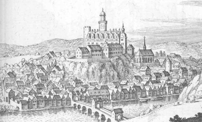
Burg Runkel and Burg Schadeck in 1655, from the Topographia Hassiae by Matthäus Merian.
(KlausFoehl Photo)
Burg Runkel.
(Bytfisch Photo)
Burg Runkel.