Medieval Castles and Fortresses (Burgen, Festung und Schlosser) in Germany
(Author’s artwork)
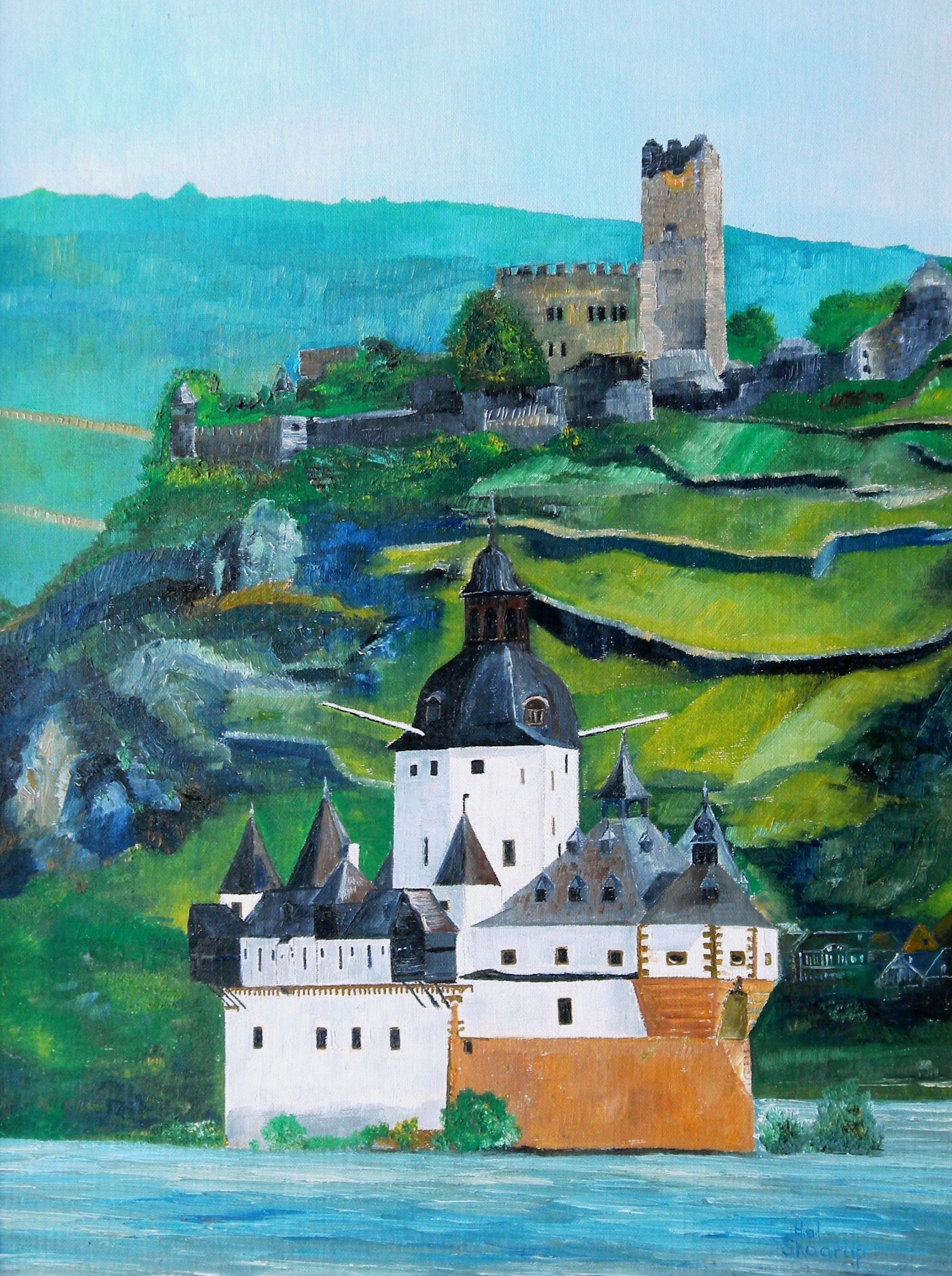
Burg Gutenfels overlooking Pfalzgrafenstein, on the Rhine River, Germany, Oil on canvas, 18 X 24.
(Author Photo)
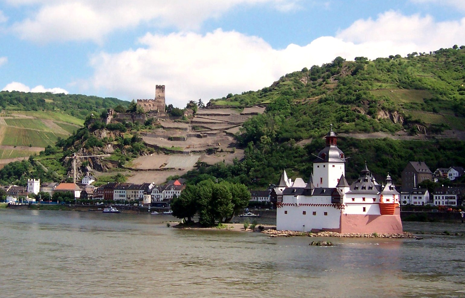
Kaub: Burg Gutenfels and Pfalzgrafenstein on the Rhine River.
(Author Photos)
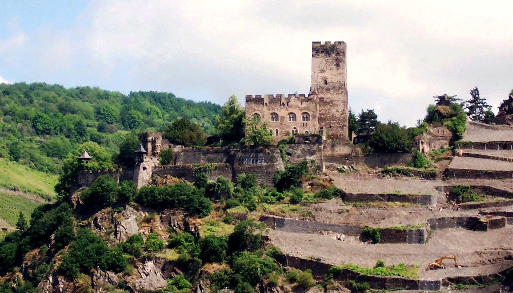
Burg Gutenfels on the Rhine River, Germany.
(Author Photo)
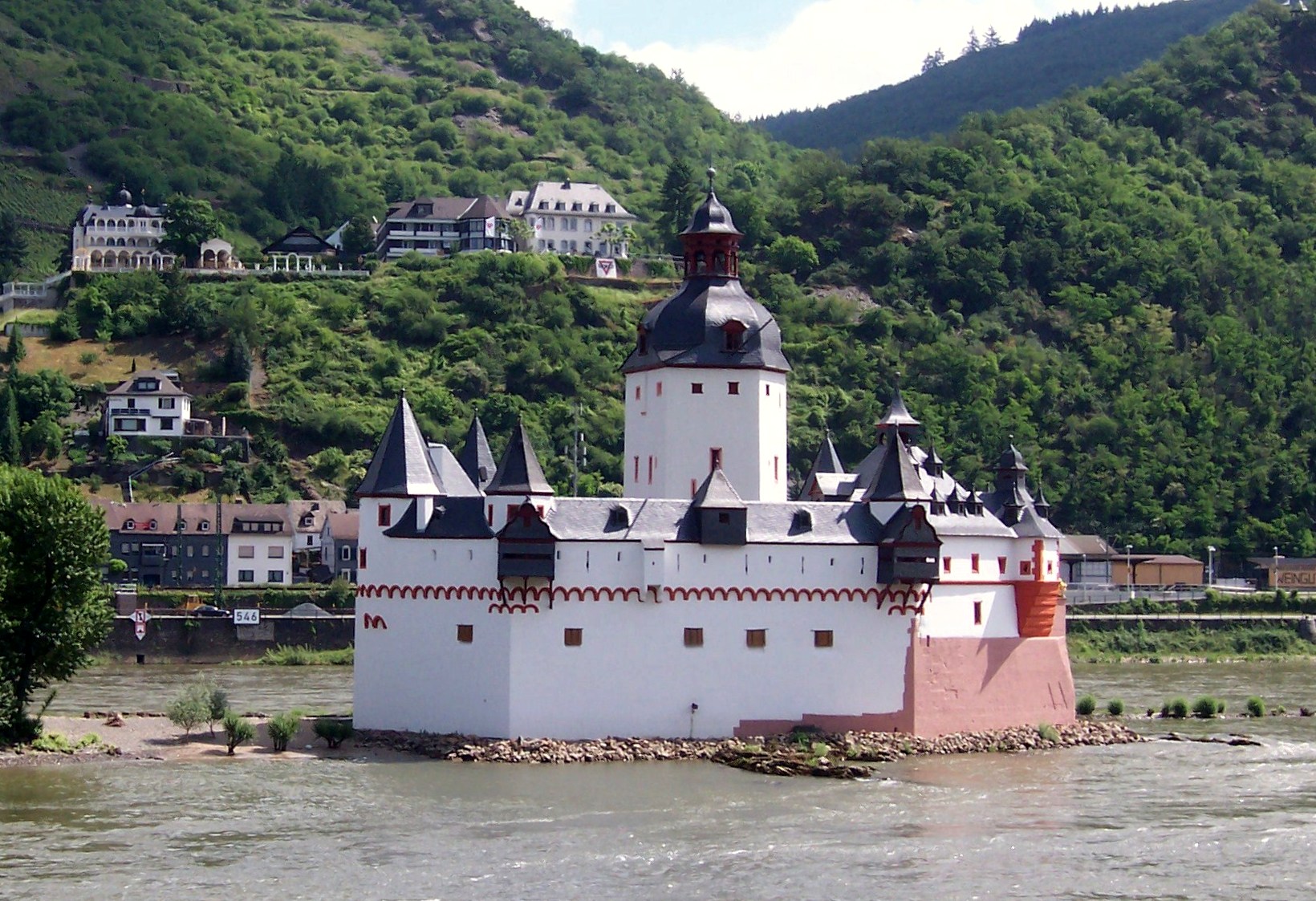
Kaub: Burg Pfalzgrafenstein is a toll castle on Falkenau island, otherwise known as Pfalz Island in the Rhine River near Kaub, Germany. Known as “the Pfalz,” this former stronghold is famous for its picturesque and unique setting. The keep of this island castle, a pentagonal tower with its point upstream, was erected 1326 to 1327 by King Ludwig the Bavarian. Around the tower, a defensive hexagonal wall was built between 1338 to 1340. In 1477 Pfalzgrafenstein was passed as deposit to the Count of Katzenelnbogen. Later additions were made in 1607 and 1755, consisting of corner turrets, the gun bastion pointing upstream, and the characteristic baroque tower cap.The castle functioned as a toll-collecting station that was not to be ignored. It worked in concert with Gutenfels Castle and the fortified town of Kaub on the right side of the river. Due to a dangerous cataract on the river’s left, about a kilometer upstream, every vessel would have to use the fairway nearer to the right bank, thus floating downstream between the mighty fortress on the vessel’s left and the town and castle on its right. A chain across the river drawn between those two fortifications forced ships to submit, and uncooperative traders could be kept in the dungeon until a ransom was delivered. The dungeon was a wooden float in the well. Unlike the vast majority of Rhine castles, “the Pfalz” was never conquered or destroyed, withstanding not only wars, but also the natural onslaughts of ice and floods by the river. Its Spartan quarters held about twenty men.
(Author Photo)
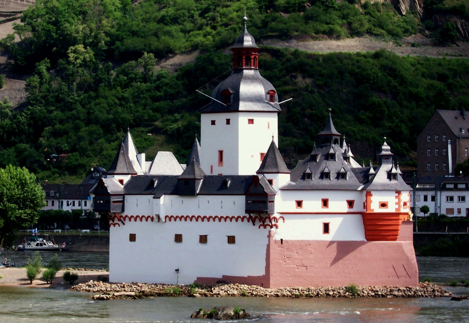
Burg Pfalzgrafenstein on the Rhine River. There is a plaque marking this as site where General Blucher crossed the ice-covered river with his army during the Napoleonic Wars before 1815.
Burg Berwartstein
(Ulli1105 Photo, 19 June 2005)
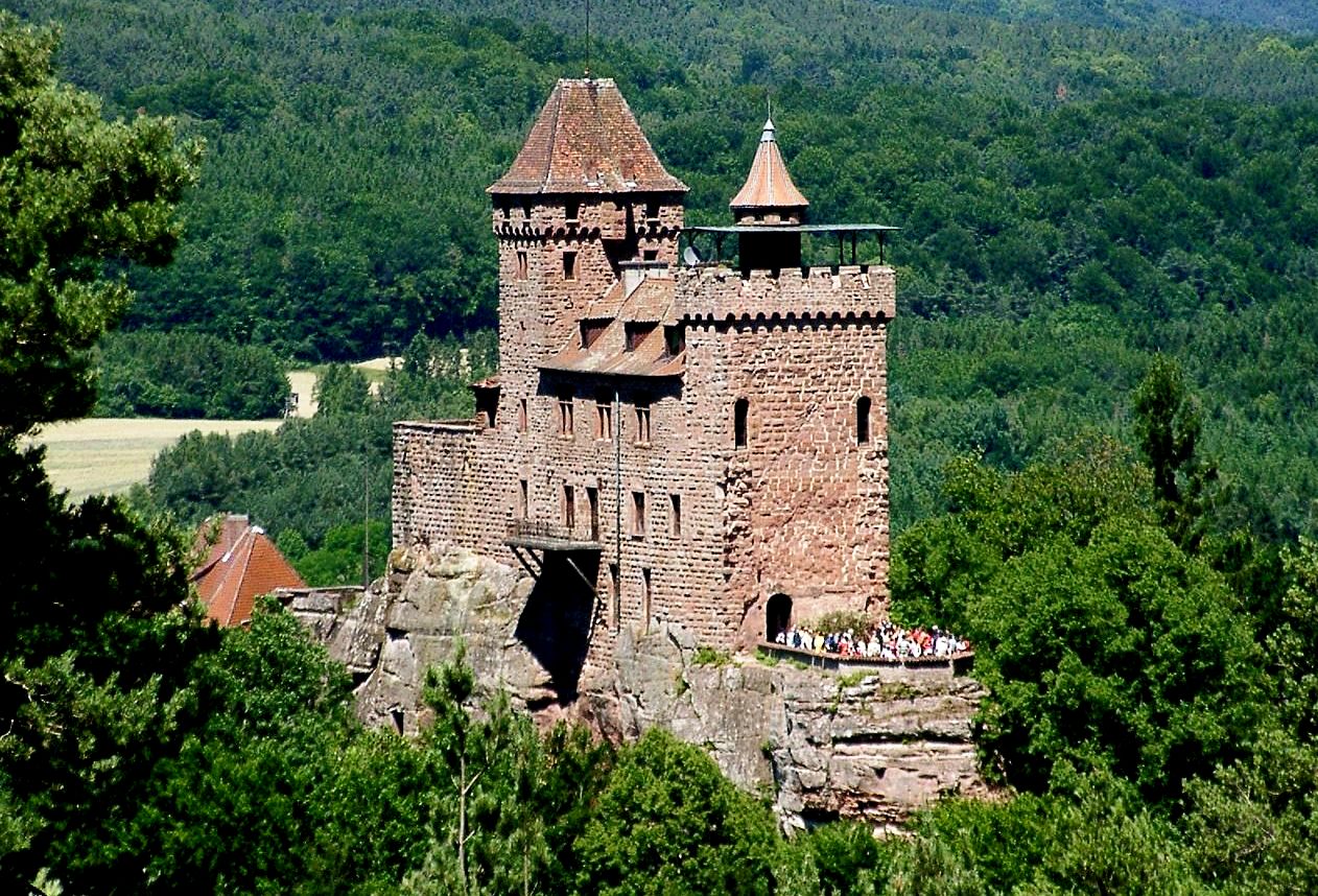
Burg Berwartstein was one of the most interesting castles that I have a clear memory of, with my parents taking us to visit it on 27 March 1960. It stands on a rocky mount in southwestern Germany, and was one of the rcok castles that were part of defences of the Palatinate during the Middle Ages. First documented in 1152, Berwarstein is one of three significant examples of rock castles in the region with the other two being Drachenfels and Altdahn. They are most notable because their stairs, passages and rooms are carved out of the living rock to form part of the accommodation essential to the defence of the castle. Although Berwartstein Castle appears more complete when compared to the ruins of neighboring castles, it is only a restoration of the original rock castle. It is the only castle in the Palatinate that was rebuilt and re-inhabited after its demolition. (Visited 27 Mar 1982, 28 Nov 1982, 5 March 1990, 16 May 1990, May 2008, fall 1997)
(Claus Ableiter Photo)
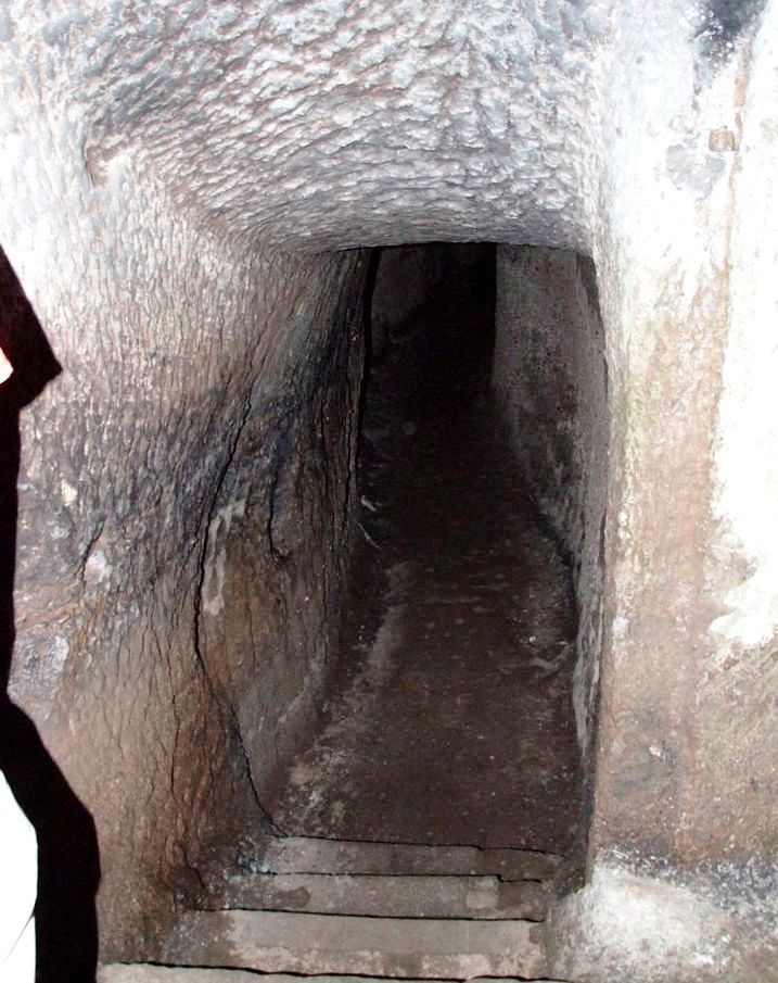
Rock cut passageways leading under Berwartstein. Carved out of the cliff and accessible even today are corridors and passageways which used to be part of the large underground defence network. Although not accessible today, there was once a tunnel from the castle to the village below. These tunnels were hewn out with hammer and chisel and partly dug through the soil. One memory I have from those days, is that the guide took a group of us through an underground tunnel that wound some distance from the entrance to the interior storage chamber. The guide was the only one with a flashlight, so we all joined hands in a chain link to go through the dark path (cobwebs and all). On reaching the other end we came into a room dubbed “casemate II”, with a central pillar holding up the ceiling – it had been carved out of the living rock!
(CB Photo)
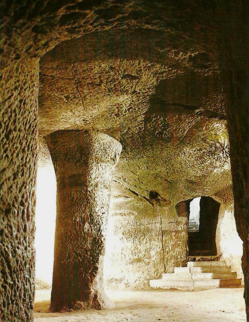
Casemate II, as it appeared when we came out of the tunnel – quite the introduction to castle tunnel spelunking! I remember my father explaining that the robber knights operating from this castle created a problem for the rulers in the area, so they commissioned one of their best knights to go and sort them out. He managed to get the best of them, but on reflection decided they had a pretty good scheme going, and so he joined them, taking over the business, so to speak. Even more remarkable, the fortress was so well defended, the Robber Knight died of old age, quite rare for the profession. I am going to include some details of this castle, much of which is typical of the many I have explored during our time in Germany.
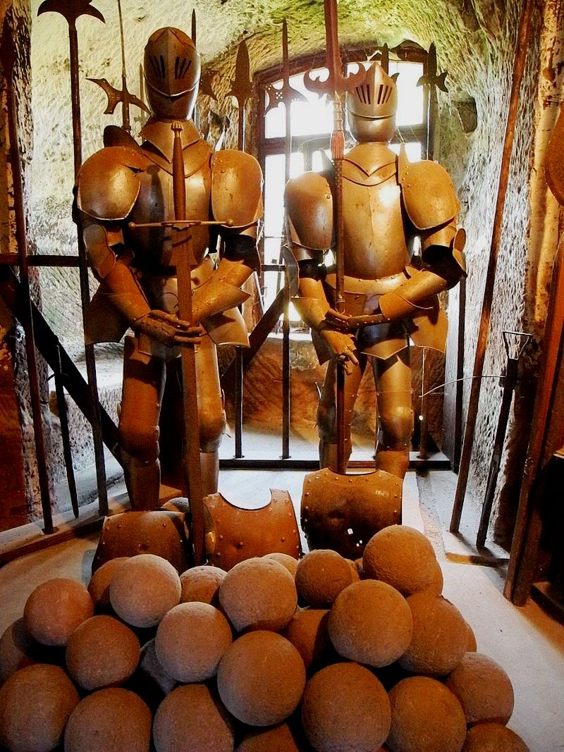
(Franz Photo, 1 Oct 2011)
Armour and stone catapult/cannon balls. At the age of eight, these were the first I had seen. During the 13th century, feudal tenants, who carried the name “von Berwartstein” inhabited the castle, which they used as a base for raids in the manner of robber barons. The imperial cities of Strasbourg and Hagenau joined forces against the von Berwartsteins. Following several weeks of futile attacks against the castle, they succeeded in taking it in 1314, with the help of a traitor. A large amount of booty and about 30 prisoners were taken to Strasbourg. The knights of Berwartstein were permitted to buy the prisoners back for a large ransom. The knights of Berwartstein were forced to sell their castle to the brothers Ort and Ulrich von Weingarten. Four years later the castle became the property of Weissenburg Abbey. The monastery at Weissenburg placed the castle in stewardship and established a feudal system. This allowed for the dismissal of vassals who became too presumptuous. Thus the monastery held possession of the castle for some time. This could have continued indefinitely had the last steward of the castle (Erhard Wyler) not gone too far. When he began feuding with the knights of Drachenfels, the Elector of the Palatinate took the opportunity to bring the Berwartstein Castle under his control. Because of his dynastic ambitions, the Elector of the Palatinate wanted to bring all of the Weissenburg estate under his control. To accomplish this, in 1480 he ordered the knight, Hans von Trotha, who was Marshal and Commander in Chief of the Palatinate forces, to acquire to Berwartstein. In this way he could enlarge the property at a cost to the Monastery of Weissenburg. For the quarrelsome knight this was a pleasure to fulfil, since this gave him a chance to take personal revenge on the Abbot of Weissenburg. Years before, Abbot Heinrich von Homburg had imposed a church fine on his brother, Bishop Thilo.
As a starting point for this conquering expedition, this experienced warrior first renovated the castle to improve its appearance. He built strong ramparts and bastions as well as the outwork and tower called Little France castle. After von Trotha’s death, Berwartstein Castle was inherited by his son Christoph and, when he died, it went to his son-in-law, Friedrich von Fleckenstein and remained in the hands of this family for three generations. During this time, the castle was destroyed by fire in 1591, and, since there is no mention of any attacks, it is presumed that the castle was hit by lightning. Even though the main sections of the castle were not destroyed by the fire, it stood empty and unused for many years. In the Peace of Westphalia (1648), Berwartstein received special mention, when it was granted to Baron Gerhard von Waldenburg, known as Schenkern, a favorite of Emperor Ferdinand III. Since he did not restore the castle, it fell into ruins. A certain Captain Bagienski purchased the castle in 1893. In 1922, it was sold to Aksel Faber of Copenhagen, and thus went into foreign ownership. Since he was seldom in Germany, he asked Alfons Wadlé to be his steward. Later Wadlé he was able to purchase the castle.
The village of Erlenbach below the castle was completely destroyed during the Second World War, and its inhabitants sought shelter in the castle. After the war, the roof had gone as well as the woodwork around windows, doors, staircases and other furnishings. Since the castle was not financially supported, Alfons Wadlé went about the renovation himself. At first he was only able to do what was essential to protect the castle from the elements. Berwartstein has an opening on the southeast side of the cliff, commonly referred to as Aufstiegskamin (entrance chimney). During the early years of the castle only the rooms and casemates in the upper cliff were complete and the shaft was the only entrance to the castle. To make it easier to ascend the shaft, a portable wooden staircase or rope ladder was placed into the castle. In the event of attack, the staircase or ladder was hoisted up into the castle. This enabled the entrance to be defended by just one man who was supplied with boiling sap, oil or liquid to pour on any intruder attempting to ascend the shaft. This limited access to the castles inner rooms was probably the main reason it was never conquered during the Middle Ages. The narrow, almost vertical cliff on which the castle stands, rises to a height of approximately 45 metres.
(H. Zell Photo)
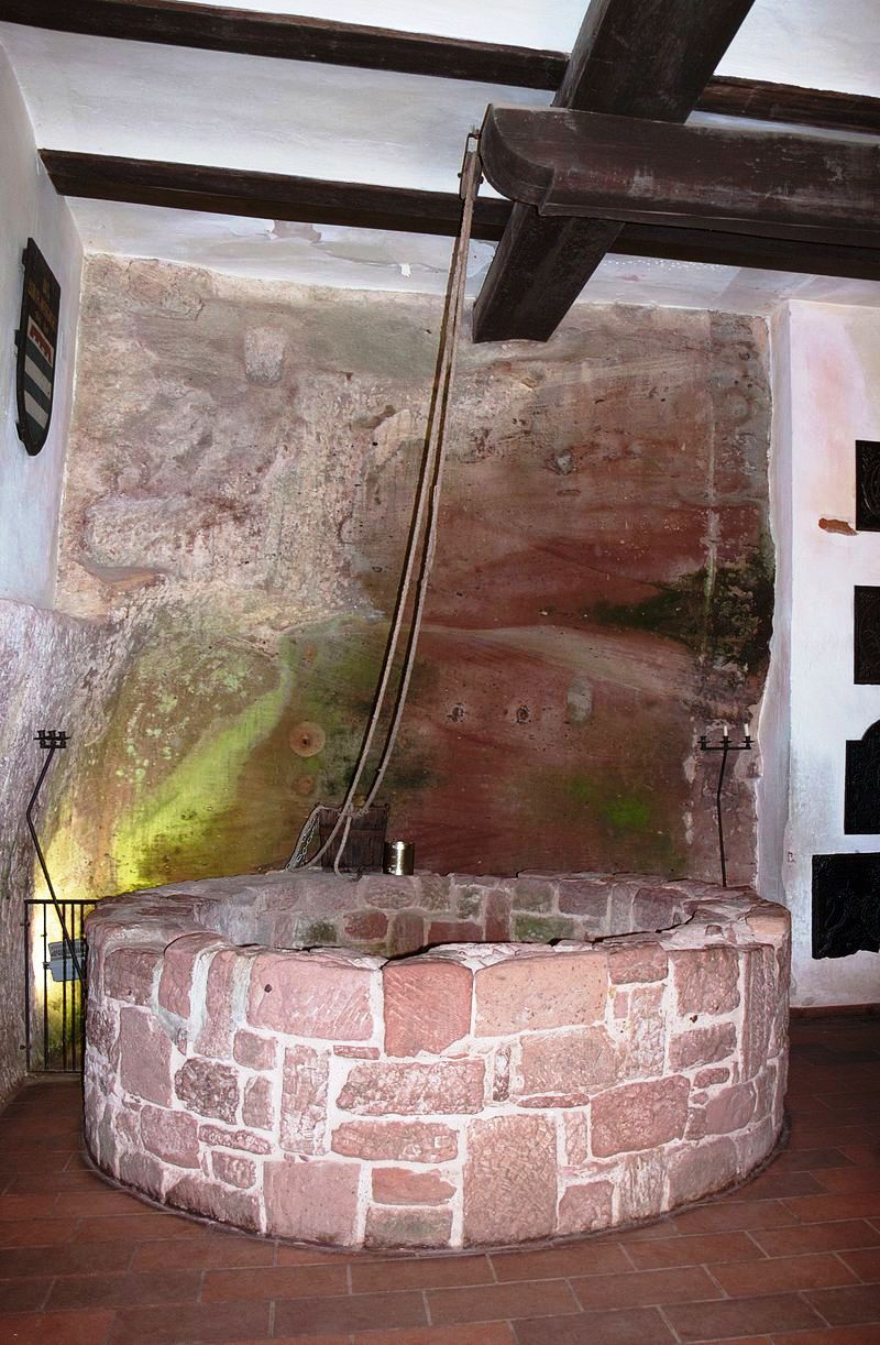
The extremely deep well is one of the castle builders’ greatest accomplishments. The well has a diameter of 2 metres (6 ft) and was hacked out of the rock to the bottom of the valley some 104 metres (341 feet) below. This was essential to the castle’s survival when under siege. The historic Great Hall or Rittersaal has a cross-vaulted ceiling. An engraving on the supporting central pillar shows that it dates to the 13th century. The south wall of the hall is made from rock and includes a hewn-out lift shaft used by the knights of Berwartstein to deliver supplies to the table and deliver food and drink from the kitchen above.
(Ulli1105 Photo)
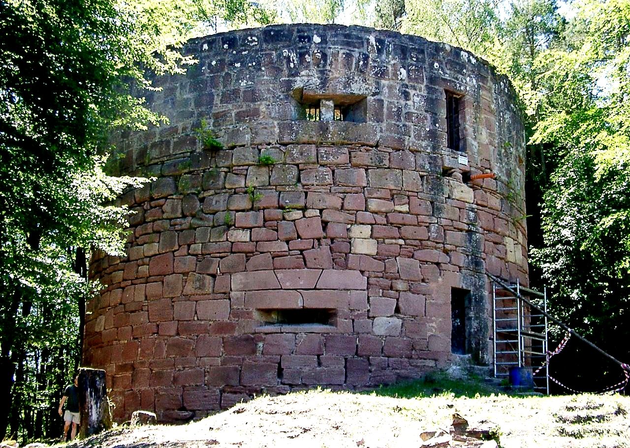
To the south on the opposite side of the valley from the castle on a spur of the Nestelberg can still be seen the tower of Little France. This tower was part of an outwork or small subsidiary castle built by the well known knight and castellan of the Berwartstein, Hans von Trotha. The tower was an important observation post and defensive position, and meant that any attackers would have found themselves caught in a crossfire between the tower and the castle. The open ground in the valley below between the tower and castle still bears the name Leichenfeld (Corpse Field), a reference to the battles fought here. There is also evidence of an underground passage between the tower and castle which is no longer accessible today since it has largely collapsed.
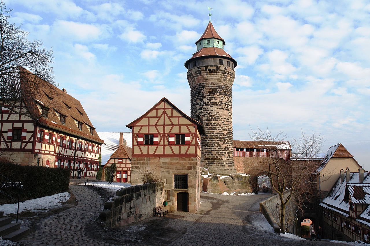
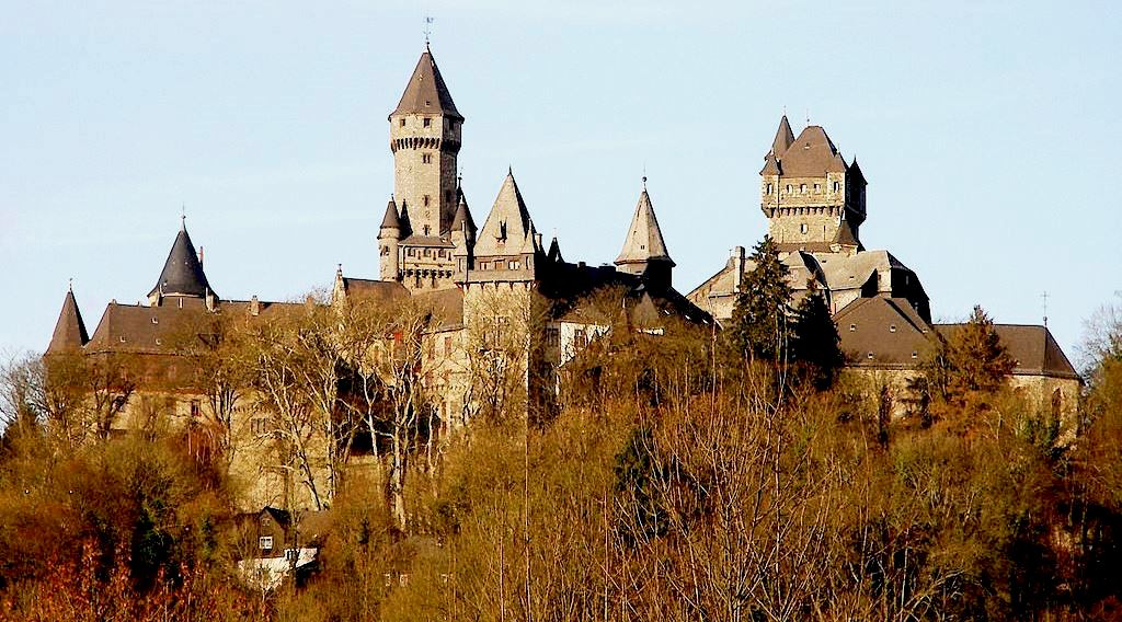
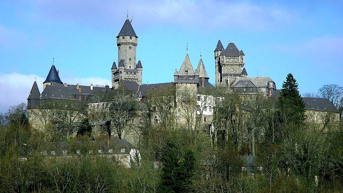
Nürnberger Burg
(ArtMechanic Photo)
Nürnberger Burg with a view of the Palas, Imperial Chapel, Heathens’ Tower on the left, Sinwell Tower in the middle left, the Pentagonal Tower, the Imperial Stables and Luginsland Tower on the right. In the Middle Ages, German Kings, (respectively Holy Roman Emperors after their coronation by the Pope) did not have a capital, but travelled from one of their castles (Kaiserpfalz or Imperial castle) to the next. For this reason, the castle at Nürnberg became an important imperial castle, and in the following centuries, all German kings and emperors stayed at the castle, most of whom did so on several occasions. Nuremberg Castle is comprised of three sections: the Imperial castle (Kaiserburg), the former Burgraves’ castle (Burggrafenburg), and the buildings erected by the Imperial City at the eastern site (Reichsstädtische Bauten).
The first fortified buildings appear to have been erected around 1000. Thereafter, three major construction periods may be distinguished: The castle was built under the Salian kings respectively Holy Roman Emperors (1027–1125). A new castle was built under the Hohenstaufen emperors (1138–1254). Reconstruction of the Palas as well as various modifications and additions in the late medieval centuries took place. The castle lost its importance after the Thirty Year’s War (1618 to 1648). In the 19th century with its general interest in the medieval period, some modifications were added. During the Nazi period, in preparation of the Nuremberg party rally in 1936, it was “returned to its original state.” A few years later, during the Second World War and its air raids in 1944/1945, a large part of the castle was laid in ruins. It took some thirty years to complete the rebuilding and restoration to its present state.
(Kolossos Photo)
Nürnberger Burg, Tiefer Brunnen (deep well, small building with gable roof in the middle) and Sinwellturm (Sinwell Tower). The complex consists of a group of medieval fortified buildings on a sandstone ridge ridge dominating the historical center of Nuremberg in Bavaria, Germany. The castle, together with its city walls, was considered to be one of Europe’s most formidable medieval fortifications. It represented the power and importance of the Holy Roman Empire and the outstanding role of the Imperial City of Nuremberg.
Wartburg
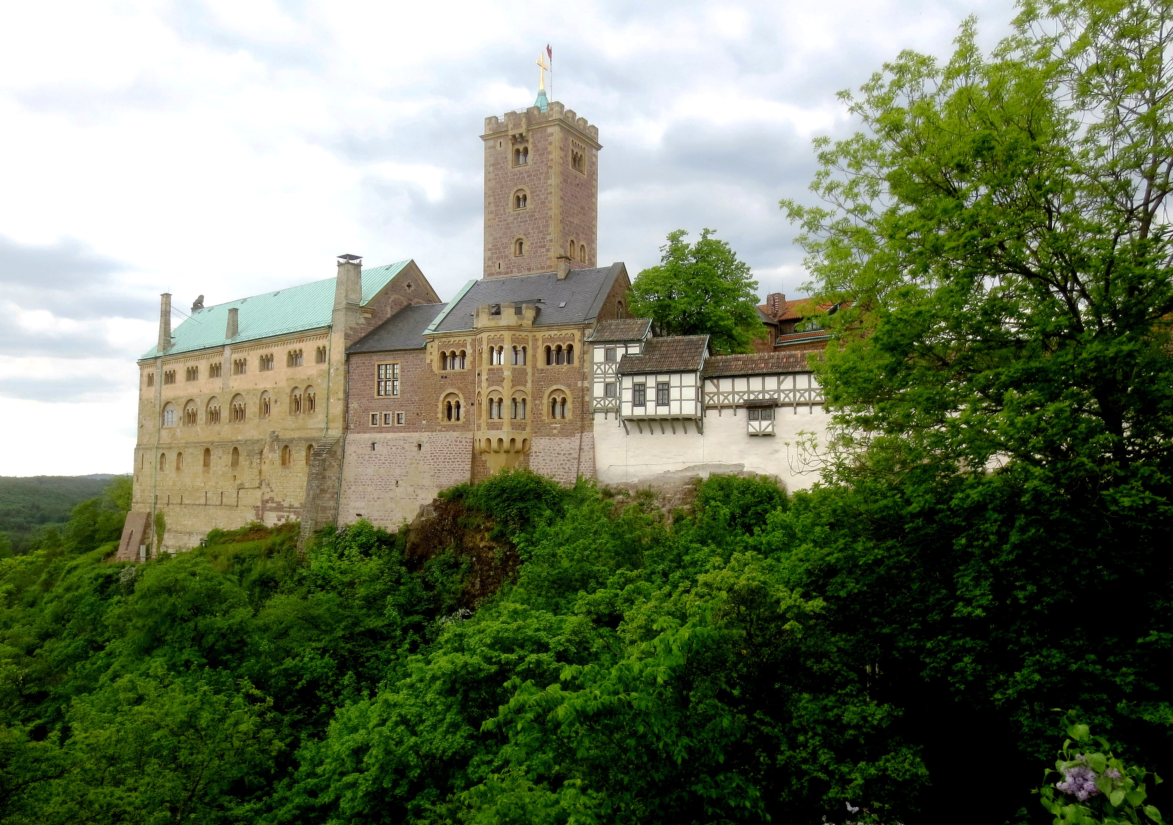
(Author Photo)
Eisenach: Wartburg Castle, overlooking the town of Eisenach in the state of Thuringia, Germany, 27 May 2016. Originally built in Middle Ages, The Wartburg stands on a cliff rising 410 meters (1,350 ft) to the southwest of and overlooking the town of Eisenach, in the state of Thuringia, Germany. It was the home of St. Elisabeth of Hungary, the place where Martin Luther translated the New Testament of the Bible into German, the site of the Wartburg festival of 1817 and the supposed setting for the possibly legendary Sängerkrieg. It was an important inspiration for Ludwig II when he decided to build Neuschwanstein Castle. The Wartburg castle contains substantial original structures from the 12th through 15th centuries, but much of the interior dates back only to the 19th century.
The castle’s foundation was laid about 1067 by the Thuringian count of Schauenburg, Ludwig der Springer, a relative of the Counts of Rieneck in Franconia. Together with its larger sister castle Neuenburg in the present-day town of Freyburg, the Wartburg secured the extreme borders of his traditional territories. Ludwig der Spring is said to have had clay from his lands transported to the top of the hill, which was not quite within his lands, so he might swear that the castle was built on his soil. The castle was first mentioned in a written document in 1080 by Bruno, Bishop of Merseburg, in his De Bello Saxonico (“The Saxon War”) as Wartberg. During the Investiture Controversy, Ludwig’s henchmen attacked a military contingent of King Henry IV of Germany. The count remained a fierce opponent of the Salian rulers, and upon the extinction of the line, his son Louis I was elevated to the rank of a Landgrave in Thuringia by the new German king Lothair of Supplinburg in 1131.
From 1172 to 1211, the Wartburg was one of the most important princes’ courts in the German Reich. Hermann I supported poets like Walther von der Vogelweide and Wolfram von Eschenbach who wrote part of his Parzival here in 1203. The castle thus became the setting for the legendary Sängerkrieg, or Minstrels’ Contest in which such Minnesänger as Walther von der Vogelweide, Wolfram von Eschenbach, Albrecht von Halberstadt (the translator of Ovid) and many others supposedly took part in 1206/1207. The legend of this event was later used by Richard Wagner in his opera Tannhäuser.
At the age of four, St. Elisabeth of Hungary was sent by her mother to the Wartburg to be raised to become consort of Landgrave Ludwig IV of Thuringia. From 1211 to 1228, she lived in the castle and was renowned for her charitable work. In 1221, Elisabeth married Ludwig. In 1227, Ludwig died on the Crusade and she followed her confessor Father Konrad to Marburg. Elisabeth died there in 1231 at the age of 24 and was canonized as a saint of the Roman Catholic Church, just five years after her death. In 1247, Heinrich Raspe, the last landgrave of Thuringia of his line and an anti-king of Germany, died at the Wartburg. He was succeeded by Henry III, Margrave of Meissen. In 1320, substantial reconstruction work was done after the castle had been damaged in a fire caused by lightning in 1317 or 1318. A chapel was added to the Palas. The Wartburg remained the seat of the Thuringian landgraves until 1440. From May 1521 to March 1522, Martin Luther stayed at the castle under the name of Junker Jörg (the Knight George), after he had been taken there for his safety at the request of Frederick the Wise following his excommunication by Pope Leo X and his refusal to recant at the Diet of Worms. It was during this period that Luther translated the New Testament from ancient Greek into German in just ten weeks. Luther’s work was not the first German translation of the Bible but it quickly became the most well known and most widely circulated.
From 1540 until his death in 1548, Fritz Erbe, an Anabaptist farmer from Herda, was held captive in the dungeon of the south tower, because he refused to abjure anabaptism. After his death, he was buried in the Wartburg near the chapel of St. Elisabeth. In 1925, a handwritten signature of Fritz Erbe was found on the prison wall. Over the next few centuries, the castle fell increasingly into disuse and disrepair, especially after the end of the Thirty Years’ War when it had served as a refuge for the ruling family. In 1777, Johann Wolfgang von Goethe stayed at the Wartburg for five weeks, making various drawings of the buildings. On 18 October 1817, the first Wartburg festival took place. About 500 students, members of the newly founded German Burschenschaften (fraternities), came together at the castle to celebrate the German victory over Napoleon four years before and the 300th anniversary of the Reformation, condemn conservatism and call for German unity under the motto “Honour – Freedom – Fatherland”. Speakers at the event included Heinrich Hermann Riemann, a veteran of the Lützow Free Corps, the philosophy student Ludwig Rödiger, and Hans Ferdinand Massmann. This event and a similar gathering at Wartburg during the Revolutions of 1848 are considered seminal moments in the movement for German unification.
During the rule of the House of Saxe-Weimar-Eisenach, Grand Duke Karl Alexander ordered the reconstruction of Wartburg in 1838. The lead architect was Hugo von Ritgen, for whom it became a life’s work. In fact, it was finished only a year after his death in 1889. Drawing on a suggestion by Goethe that the Wartburg would serve well as a museum, Maria Pavlovna and her son Karl Alexander also founded the art collection (Kunstkammer) that became the nucleus of today’s museum. The reign of the House of Saxe-Weimar-Eisenach ended in the German Revolution in 1918. In 1922, the Wartburg Stiftung (Wartburg Foundation) was established to ensure the castle’s maintenance.
After the end of the Second World War, Soviet occupation forces took the renowned collection of weapons and armour. Its whereabouts still remain unknown. The Rüstkammer (armoury) of the Wartburg once contained a notable collection of about 800 pieces, from the splendid armour of King Henry II of France, to the items of Frederick the Wise, Pope Julius II and Bernhard von Weimar. All these objects were taken by the Soviet Occupation Army in 1946 and have disappeared in Russia. Two helmets, two swords, a prince’s and a boy’s armour, however, were found in a temporary store at the time and a few pieces were given back by the USSR in the 1960s. The new Russian Government has been petitioned to help locate the missing treasures. Under communist rule during the time of the GDR extensive reconstruction took place in 1952-54. In particular, much of the palas was restored to its original Romanesque style. A new stairway was erected next to the palas. In 1967, the castle was the site of celebrations of the GDR’s national jubilee, the 900th anniversary of the Wartburg’s foundation, the 450th anniversary of the beginning of Luther’s Reformation and the 150th anniversary of the Wartburg Festival. In 1983, it was the central point of the celebrations on account of the 500th birthday of Martin Luther. The largest structure of the Wartburg is the Palas, originally built in late Romanesque style between 1157 and 1170. It is considered the best-preserved non-ecclesial Romanesque building north of the Alps. (Wikipedia)
Burg Gleichen
(Author Photo)
Burg Gleichen, Thuringia, Germany. Gleichen Castle owes its fame to the legend of the bigamous Count von Gleichen, who returned home from the Crusades with a second wife. The three castles known collectively as the “Drei Gleichen” are Gleichen Castle, Mühlburg Castle and Wachsenburg Castle. They are approx. 20 km from Erfurt in the Drei Gleichen conservation area. Burg Gleichen, the Wanderslebener Gleiche (1221 ft. above sea level), was besieged unsuccessfully by the emperor Henry IVin 1088. It was the seat of a line of counts, one of whom, Ernest III, a crusader, is the subject of a romantic legend. Having been captured, he was released from his imprisonment by a Turkish woman, who returned with him to Germany and became his wife, a papal dispensation allowing him to live with two wives at the same time. After belonging to the elector of Mainz the castle became the property of Prussia in 1803.
(Zerbie Photo)
Burg Gleichen, aerial view.
Burg Muhlberg
(Author Photo)
Burg Muhlberg, Thuringia, Germany. Mühlburg (1309 ft. above sea level), the second castle of the Drei Gleichen group, existed as early as 704 and was besieged by Henry IV in 1087. It came into the hands of Prussia in 1803.
(CTHOE Photo)
Veste Wachsenburg (1358 ft.), the third castle of the Drei Gleichen group, was still inhabited in 1911 and contained a collection of weapons and pictures belonging to its owner, the duke of Saxe-Coburg-Gotha, whose family obtained possession of it in 1368. It was built about 935. The castle was extensively rebuilt in the 17th and 19th century. The well-preserved castle (most recently restored in the 1990s) now houses a museum, a hotel and a restaurant. It was built by Hersfeld Monastery. The castle stand on a hill approximately 93 meters high. In 1441 a notorious robber baron took control of the castle and made it his base for his raids on the merchants of Erfurt.
Burg Hohenzollern
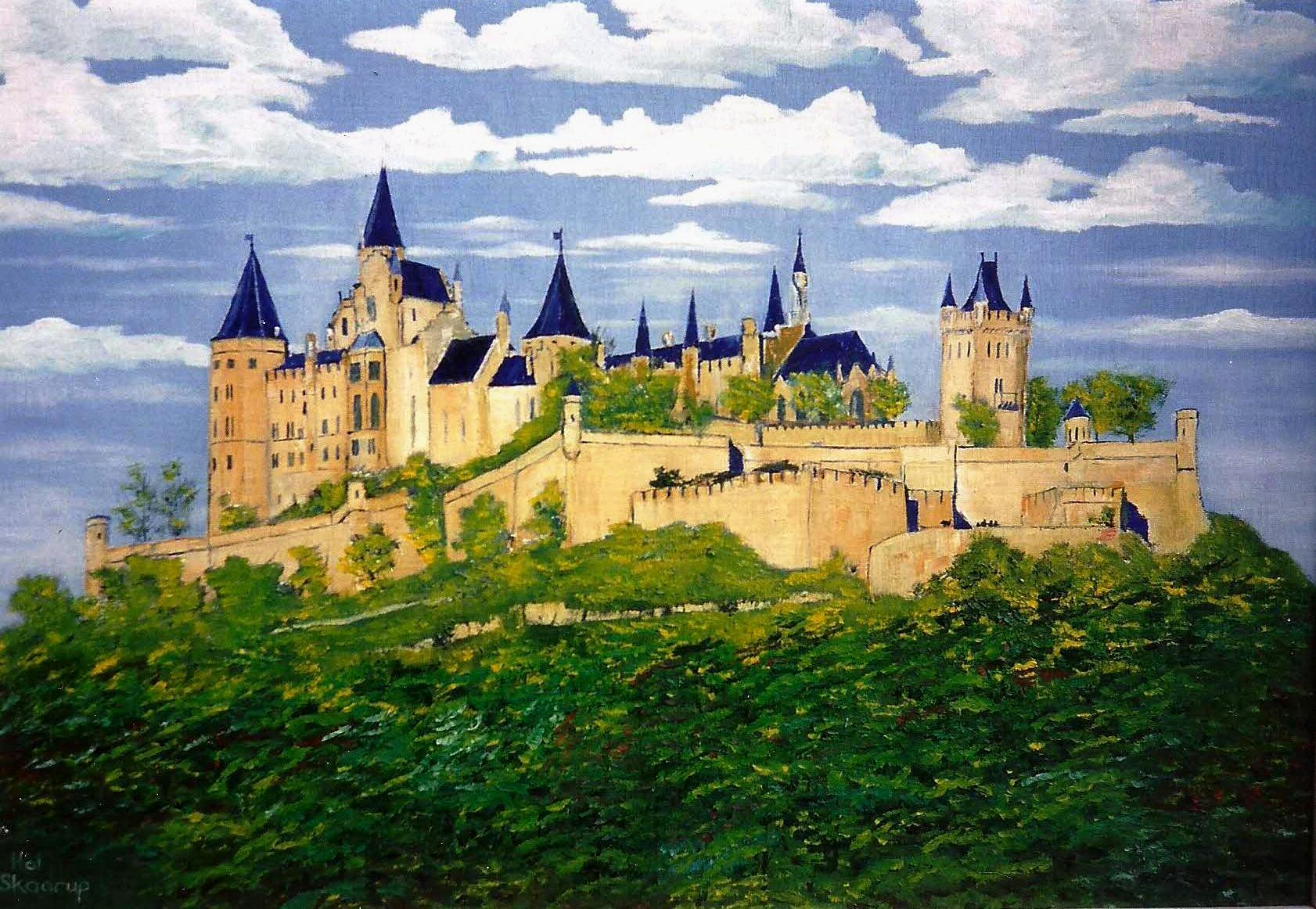
(Author’s artwork)
Burg Hohenzollern, Germany. Oil on canvas, 18 X 24.
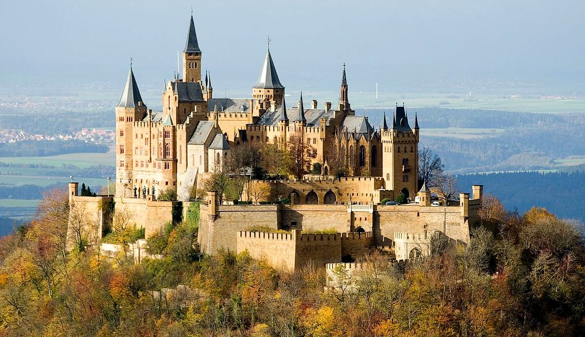
(A. Kniesel Photo, 1 Nov 2006)
Burg Hohenzollern is the ancestral seat of the imperial House of Hohenzollern. It is the third of three castles built on the site, and is located on top of Mount Hohenzollern, above and south of the town of Hechingen, on the edge of the Swabian Jura of central Baden-Würtemberg, Germany. The first castle on the mountain was constructed in the early 11th century. Over the years the House of Hohenzollern split several times, but the castle remained with the branch of the family, that later acquired its own imperial throne. This castle was completely destroyed in 1423 after a ten-month siege by the free imperial cities of Swabia. The second castle, a larger and sturdier structure, was constructed from 1454 to 1461, which served as a refuge for the Catholic Swabian Hohenzollerns, including during the Thirty Year’s War. By the end of the 18th century it was thought to have lost its strategic importance and gradually fell into disrepair, leading to the demolition of several dilapidated buildings.
The third, and current, castle was built between 1846 and 1867 as a family memorial by Hohenzollern King Frederick William IV of Prussia. No member of the Hohenzollern family was in permanent or regular residence when it was completed, and none of the three German Emperors of the late 19th and early 20th century German Empire occupied the castle; in 1945 it briefly became the home of the former Crown Prince Wilhelm of Germany, son of the last Hohenzollern monarch, Kaiser Wilhelm II.
Schloss Heidelberg
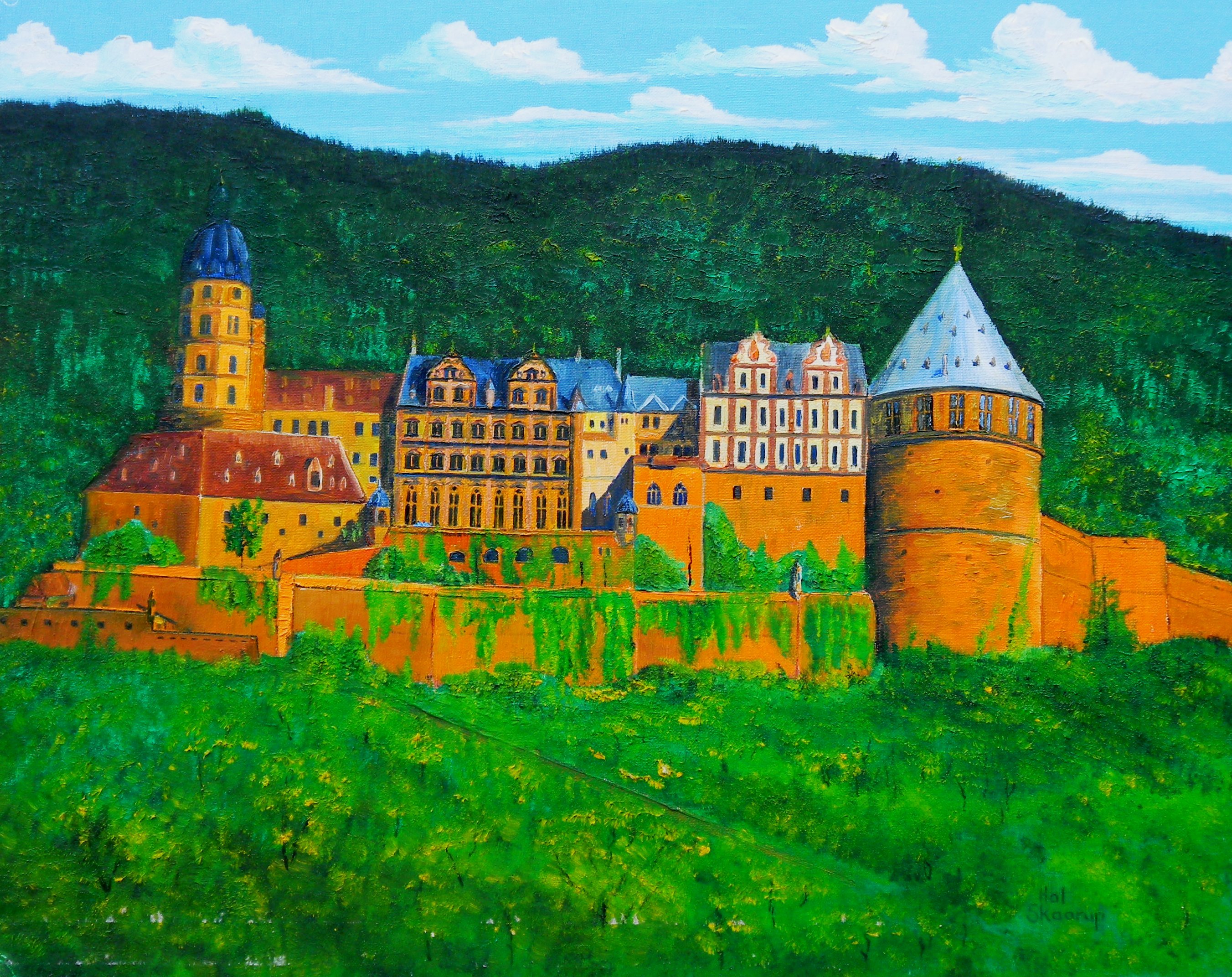
(Author’s artwork)
Heidelberger Schloss, as it might have looked before its destruction. Oil on canvas, 11 X 14.
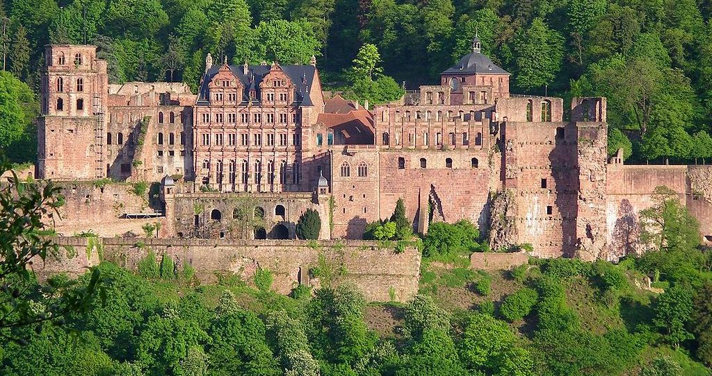
(Pumuckel42 Photo)
Schloss Heidelberg, Germany, as it appears now (Heidelberg-Schloß, 1 May 2005).
Many Canadians with the Canadian Forces and their families lived in Heidelberg, while their military members served with the Allied Air Forces Central Europe (AAFCE), which was the NATO command tasked with air and air defence operations in NATO’s Allied Forces Central Europe (AFCENT) area of command. AAFCE had initially been activated on 2 April 1951 at Fontainebleau, France through General Dwight D. Eisenhower’s General Order No. 1. AAFCE consisted of two allied tactical air forces, Second Tactical Air Force, comprising British-Dutch No. 2 Group, RAF, Belgian-Dutch 69 Group, and British-Belgian No. 83 Group, RAF. Fourth Allied Tactical Air Force, comprised of the Twelfth Air Force, French 1er Air Division, and No. Canadian Air Division, RCAF. The peacetime headquarters of 4 ATAF was in Heidelberg, which is why many Canadians served there.
Schloss Heidelberg is a ruin in Germany and landmark of the city of Heidelberg. Heidelberg was first mentioned in 1196 as “Heidelberch”. The castle ruins are among the most important Renaissance structures north of the Alps. The castle has only been partially rebuilt since its demolition in the 17th and 18th centuries. It is located 80 metres (260 ft) up the northern part of the Konigstuhl ,hillside, and thereby dominates the view of the old town. The earliest castle structure near this site was built before 1214 and later expanded into two castles c1294; however, in 1537, a lightning bolt destroyed the upper castle. The present structures had been expanded by 1650, before damage by later wars and fires. In 1764, another lightning bolt caused a fire which destroyed some rebuilt sections. When Ruprecht became the King of Germany in 1401, the castle was so small that on his return from his coronation, he had to camp out in the Augustinians’ monastery, on the site of today’s University Square. What he desired was more space for his entourage and court and to impress his guests, but also additional defences to turn the castle into a fortress. After Ruprecht’s death in 1410, his land was divided between his four sons.
During the reign of Louis V, Elector Palatine (1508–1544) that Martin Luther came to Heidelberg to defend one of his theses (Heidelberg Disputation) and paid a visit to the castle. He was shown around by Louis’s younger brother, Wolfgang, Count Palatine, and in a letter to his friend George Spalatin praised the castle’s beauty and its defences. In 1618, Protestants rebelling against the Holy Roman Empire offered the crown of Bohemia to Frederick V, Elector Palatine, who accepted despite misgivings and in doing so triggered the outbreak of the Thirty Year’s War. The Thirty Years’ War was a religious war fought primarily in Central Europe between 1618 and 1648. It resulted in the deaths of over 8 million people, including 20% of the German population, making it one of the most destructive conflicts in human history.
It was during the Thirty Years War that arms were raised against the castle for the first time. This period marks the end of the castle’s construction; the centuries to follow brought with them destruction and rebuilding. After his defeat at the Battle of White Mountain on 8 November 1620, Frederick V was on the run as an outlaw and had to release his troops prematurely, leaving the Palatinate undefended against General Tilly, the supreme commander of the Imperial and Holy Roman Empire’s troops. On 26 August 1622, Tilly commenced his attack on Heidelberg, taking the town on 16 September, and the castle few days later.
When the Swedes captured Heidelberg on 5 May 1633 and opened fire on the castle from the Königstuhl hill behind it, Tilly handed over the castle. The following year, the emperor’s troops tried to recapture the castle, but it was not until July 1635 that they succeeded. It remained in their possession until the Peace of Westphalia ending the Thirty Years War was signed. The new ruler, Chalres Louis (Karl Ludwig) and his family did not move into the ruined castle until 7 October 1649.
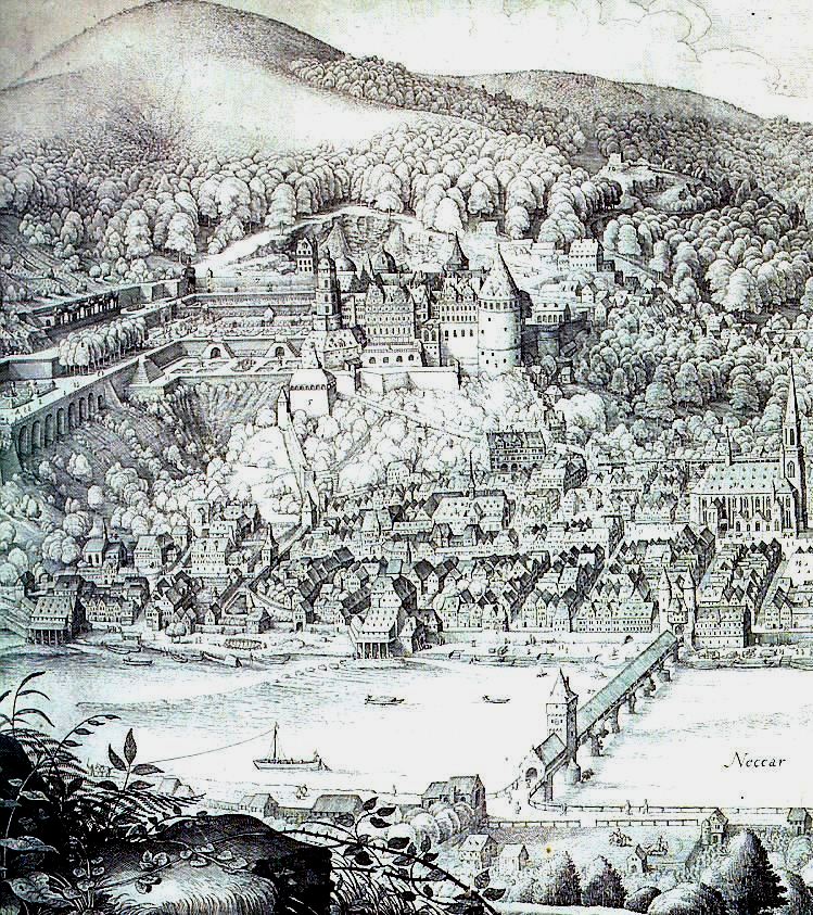
Schloss Heidelberg on the Neckar River showing the Alte Bruecke (Old Bridge), Heilgigeistkirche (Church of the Holy Ghost), from a 1643 engraving by Matthäus Merian. After the death of Charles II, Elector Palatine, Louis XIV of France demanded the surrender of the allodial title in favour of the Duchess of Orléans, Elizabeth Charlotte, Princess Palatine, who he claimed was the rightful heir to the Simmern lands. On 29 September 1688, the French troops marched into the Palatinate of the Rhine and on 24 October moved into Heidelberg, which had been deserted by Philipp Wilhelm, the new Elector Palatine. At war against the allied European powers, France’s war council decided to destroy all fortifications and to lay waste to the Palatinate (Brûlez le Palatinat!), in order to prevent an enemy attack from this area. As the French withdrew from the castle on 2 March 1689, they set fire to it and blew the front off the Fat Tower. Portions of the town were also burned, but the mercy of a French general, René de Froulay de Tessé, who told the townspeople to set small fires in their homes to create smoke and the illusion of burning prevented wider destruction.
Immediately upon his accession in 1690, Johann Wilhelm, Elector palatine had the walls and towers rebuilt. When the French again reached the gates of Heidelberg in 1691 and 1692, the town’s defenses were so good that they did not gain entry. On 18 May 1693, the French were yet again at the town’s gates and took it on 22 May. However, they did not attain control of the castle and destroyed the town in attempt to weaken the castle’s main support base. The castle’s occupants capitulated the next day. The French then took the opportunity to finish the destruction of Heidelberg that they began in 1689, after their hurried exit from the town. The towers and walls that had survived the last wave of destruction, were blown up with mines.
In 1697 the Treaty of Ryswick was signed, marking the end of the War of the Grand Alliance and finally bringing peace to the town. Plans were made to pull down the castle and to reuse parts of it for a new palace in the valley. When difficulties with this plan became apparent, the castle was partially repaired. In the following decades, basic repairs were made, but Heidelberg Castle remained essentially a ruin. In 1767, the south wall was quarried for stone to build Schwetzingen Castle. In 1784, the vaults in the Ottoheinrich wing were filled in, and the castle used as a source of building materials.
The question of whether the castle should be completely restored was discussed for a long time. Eventually, a detailed plan was developed for preserving or repairing the main building. The planners completed their work in 1890, which led a commission of specialists from across Germany to decide that while a complete or partial rebuilding of the castle was not possible, it was possible to preserve it in its current condition. Only the Friedrich Building, whose interiors were fire damaged, but not ruined, would be restored. This reconstruction was done from 1897 to 1900 by Karl Schäfer at the enormous cost of 520,000 Marks.
The forecourt is the area enclosed between the main gate, the upper prince’s well, the Elisabeth gate, the castle gate and the entrance to the garden. Around 1800 it was used by the overseer for drying laundry. Later on, it was used for grazing cattle, and chickens and geese were kept here. The approach to the forecourt takes you across a stone bridge, over a partially filled-in ditch. The main gate was built in 1528. The original watchhouse was destroyed in the War of the Grand Alliance, and replaced in 1718 by a round-arched entrance gate. The gate to the left of the main entrance was closed by means of a drawbridge. The former harness room, originally a coach house, was in reality begun as a fortification. After the Thirty Year’s War, it was used as a stables as well as a toolshed, garage and carriage house. (Harry B. Davis: “What Happened in Heidelberg: From Heidelberg Man to the Present”: Verlag Brausdruck GmbH, 1977)
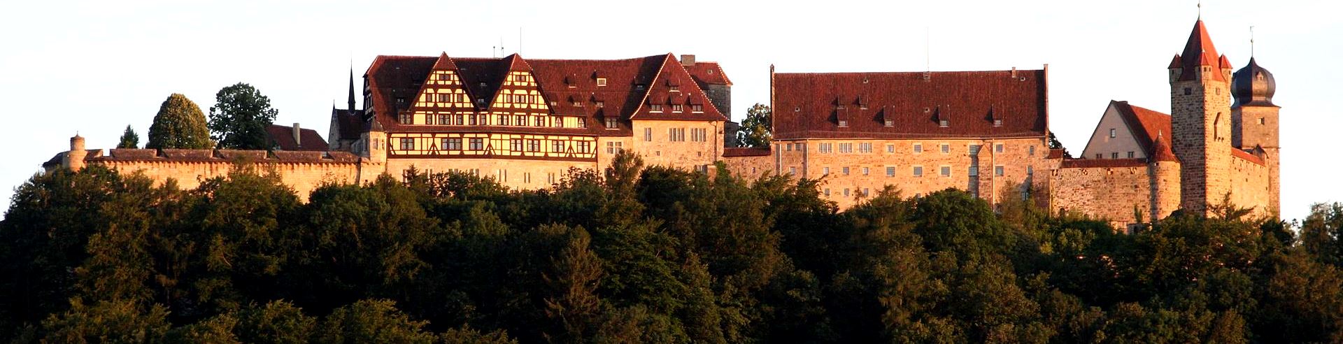
Veste Coburg
(Storfix Photo, 16 Oct 2005)
Coburg: Veste Coburg (Fortress Coburg), is one of the most well-preserved medieval fortresses of Germany. It is situated on a hill above the town of Coburg, in the Upper Franconia region of Bavaria. Veste Coburg dominates the town of Coburg on Bavaria’s border with Thuringia. It is located at an altitude of 464 meters above sea level, 167 meters above the town. Its size (around 135 meters by 260 meters) makes it one of the medium sized fortresses in Germany. The hill on which Veste Coburg stands was inhabited from the Neolithic to the early Middle Ages according to the results of excavations. The first documentary mention of Coburg occurs in 1056, in a gift by Richeza of Lotharingia. Richeza gave her properties to Anno II, Archbishop of Cologne, to allow the creation of Saalfeld Abbey in 1071. In 1075, a chapel dedicated to Saint Peter and Saint Paul is mentioned on the fortified Coberg. This document also refers to a Vogt named Gerhart, implying that the local possessions of the Saalfeld Benedictines were administered from the hill.
A document signed by Pope Honorius II in 1206 refers to a mons coburg, a hill settlement. In the 13th century, the hill overlooked the town of Trufalistat (Coburg’s predecessor) and the important trade route from Nuremberg via Erfurt to Leipzig. A document dated from 1225 uses the term sloss (palace) for the first time. At the time, the town was controlled by the Dukes of Merania (or Meran). They were followed in 1248 by the Counts of Henneberg, who ruled Coburg until 1353, save for a period from 1292-1312, when the House of Ascania (Askanien) was in charge. In 1353, Coburg fell to Friedrich, Markgraf von Meißen of the House of Wettin. His successor, Friedrich der Streitbare, was awarded the status of Elector of Saxony in 1423. Thus, Coburg – despite being in Franconia – was now referred to as “Saxony”, like other properties of the House of Wettin. As a result of the Hussite Wars, the fortifications of the Veste were expanded in 1430.
In 1485, in the Partition of Leipzig, Veste Coburg fell to the Ernestine branch of the family. A year later, Elector Friedrich der Weise and Johann der Beständige took over the rule of Coburg. Johann used the fortress as a residence from 1499. In 1506/07, Lucas Cranach the Elder, lived and worked in the Fortress. From April to October 1530, during the Diet of Augsburg, Martin Luther sought protection at the Fortress, as he was under an Imperial ban at the time. During his stay at the fortress, Luther continued with his work translating the Bible into German. In 1547, Johann Ernst moved the residence of the ducal family to a more convenient and fashionable location, Ehrenburg Palace in the town center of Coburg. The Veste then served as a fortification only.
In the further splitting of the Ernestine line, Coburg became the seat of the Herzogtum von Sachsen-Coburg, the Duchy of Saxe-Coburg. The first duke was Johann Casimir (1564-1633), who modernized the fortifications. In 1632, the fortress was unsuccessfully besieged by Imperial and Bavarian forces commanded by Albrecht von Wallenstein for seven days during the Thirty Years’ War. Its defence was commanded by Georg Christoph von Taupadel. On 17 March 1635, after a renewed siege of five months’ duration, the Veste was handed over to the Imperials under Guillaume de Lamboy.
From 1638 to 1672, Coburg and the fortress were part of the Duchy of Saxe-Altenburg. In 1672, they passed to the Dukes of Saxe-Gotha, and in 1735 it was joined to the Duchy of Saxe-Saalfeld. Following the introduction of Primogeniture by Duke Franz Josias (1697-1764), Coburg went by way of Ernst Friedrich (1724-1800) to France (1750-1806), noted art collector, and to Duke Ernst III (1784-1844), who remodeled the castle. In 1826, the Duchy of Saxe-Coburg-Gotha was created and Ernst now styled himself “Ernst I”. Military use of the fortress had ceased by 1700 and outer fortifications had been demolished in 1803-38. From 1838-60, Ernst had the run-down fortress converted into a Gothic revival residence. In 1860, use of the Zeughaus as a prison (since 1782) was discontinued. Through a successful policy of political marriages, the House of Saxe-Coburg and Gotha established links with several of the major European dynasties, including that of the United Kingdom.
The dynasty ended with the reign of Herzog Carl Eduard (1884-1954), also known as Charles Edward, Duke of Saxe-Coburg and Gotha, a grandson of Queen Victoria, who until 1919 also was the 2nd Duke of Albany in the United Kingdom. Under his rule, many changes made to the Veste Coburg in the 19th century were reversed under architect Bodo Ebhardt, with the aim of restoring a more authentic medieval look. Along with the other ruling princes of Germany, Carl Eduard was deposed in the revolutions of 1918-1919. After Carl Eduard abdicated in late 1918, the fortress came into possession of the state of Bavaria, but the former duke was allowed to live there until his death. The works of art collected by the family were gifted to the Coburger Landesstiftung, a foundation, which today runs the museum.
In 1945, the fortress was seriously damaged by artillery fire in the final days of the Second World War. After 1946, renovation works were undertaken by the new owner, the Bavarian Administration of State-owned Palaces, Gardens and Lakes. Veste Coburg is open to the public and today houses museums, including a collection of art objects and paintings that belonged to the ducal family of Saxe-Coburg and Gotha, a large collection of arms and armor, significant examples of early modern coaches and sleighs, and important collections of prints, drawings and coins. (Daniel Burger: Festungen in Bayern. Schnell + Steiner, Regensburg 2008)
(Störfix Photo)
Veste Coburg.
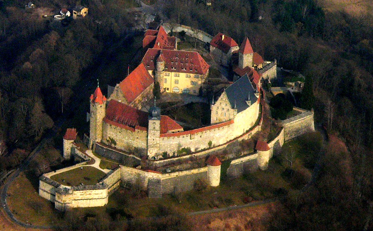
(Presse03 Photo)
Veste Coburg, aerial view.
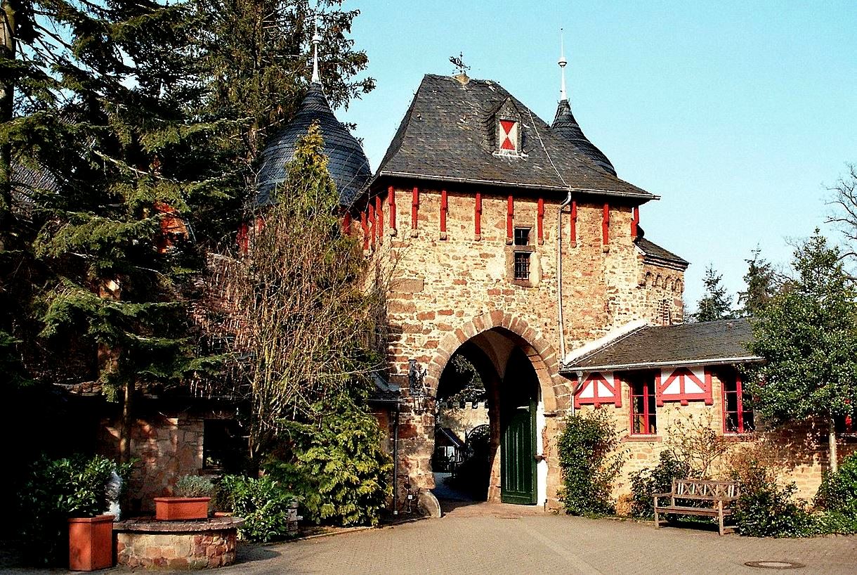
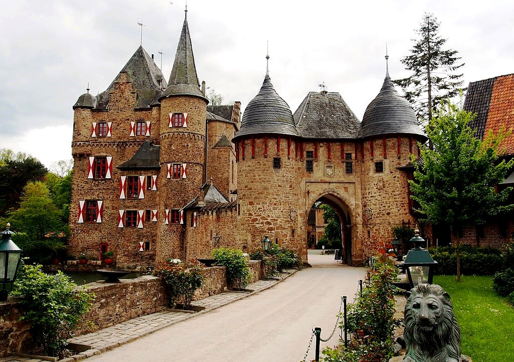
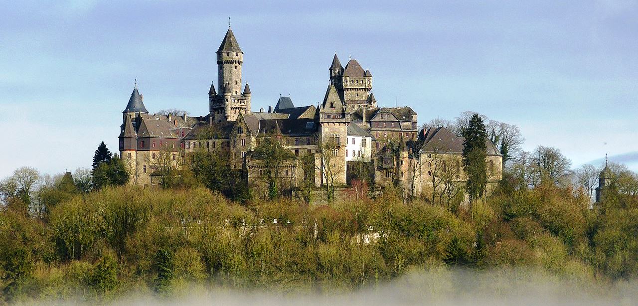
Burg Satzvey
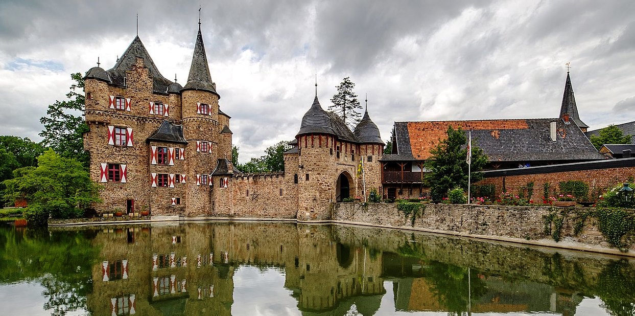
(GZagatta Photo)
Mechernich: Burg Satzvey is a medieval moated castle, originally built in the 12th century, located on the northeastern edge of the Eifel in Mechernich (district Satzvey) in Euskirchen, North Rhine-Westphalia. It is one of the best preserved moated castles in the Rhineland, retaining much of its original Rhenish structure. It was built by the ministerial nobility of the 14th and 15th centuries in the lowland (high nobility tended to build hilltop castles that were difficult to conquer). Without mountains to build on as a natural obstacle for attackers, lowland castle builders had to rely on moats and water ditches that were difficult to overcome. For this reason, moated castles were usually built on two islands and were almost always near a stream that supplied the trenches with water. The more strongly fortified main castle was thereby additionally protected by an outer castle built on a second island.
Satzvey castle was originally built on two islands surrounded by moats. In the 12th century, Satzvey castle was held by the Hofanlage family, who had named it after the river flowing through the Veybach field. The Archbishop of Cologne, Engelbert II von der Mark, gave Satzvey as a fief to Otto von Vey, who was mentioned in a document in 1368 as the first Vogt of this name. When his male line died out, his granddaughter brought her husband Heinrich von Krauthausen to the castle in 1391. In 1396, Heinrich built the first originally free-standing, two-story Gothic castle to serve as the new administrative seat. In the 15th century, the fortification of the facility was increased. The gatehouse with the twin towers was built, a kennel was built and the outer bailey was reinforced. In the second half of the 15th century the castle belonged to the von Meller family, after 1512 it was owned by various noble families until it was taken over by Wilhelm von Büllesheim in 1561. The Archbishop of Cologne supported the appropriation to maintain peace in the country.
In 1578 the Duke of Jülich, Wilhelm V the Rich, occupied the castle. After three years the lord of the castle Spies von Büllesheim, pledged his oath of allegiance to both the sovereign of Jülich and the sovereign of Cologne, Archbishop Gebhard I von Waldburg. At the end of the 16th century the bailiwick became the imperial seat of power. In 1747, Johann Spies von Büllesheim sold the castle to Karl Otto von Gymnich, placeing it in the possession of the Rhenish noble family von und zu Gymnich. In 1794, the subordinate rule of Satzvey was lost and from then on only had the status of a manor suitable for the state assembly. In 1882 the moated castle passed to the Imperial Count Dietrich Wolff-Metternich after the Gymnich died out.
Prior to 1882, there had been no major structural changes at Satzvey Castle since the 16th century. Under Dietrich Wolff-Metternich, extensive renovations and extensions were made the castle. Moats were drained, the castle house was expanded with porches and extensions and new towers were built. Buildings in the style of English stables were built on the former outer bailey, and an estate with farm buildings was added. The core and these construction measures was the existing original structure from the early 15th century. For centuries, the castle was largely spared from military destruction. However , it was badly damaged in the Second World War. In 1942, Countess Adeline Wolff Metternich zur Gracht (1919-2010) took over the inheritance after her brother Dietrich, died in the war. In 1944 she married Franz Josef Count Beissel von Gymnich zu Frens (1916–2008), a younger branch of the von and zu Gymnich family. Satzvey Castle was passed to Count Beissel von Gymnich. The young couple moved into the castle and repaired the most important components in the following years. Their four sons were born here. The couple now live in Bad Münsteifel.
In 1977 the parents transferred the property to their eldest son, Count Franz Josef Beissel von Gymnich. In order to be able to preserve the castle and to preserve the history and traditions of bygone eras, he decided to make the complex accessible to the public and organized the historical knight festival there together with his wife Jeannette and his daughter. Satzvey Castle is a well-preserved moated castle. The original castle house, the two-tower gatehouse, the north wall and the north tower are the oldest components. They have survived for 600 years and, together with the construction work of the late 19th century, form a typical German moated castle. On 19 April 2020, the attached castle bakery burned down. (Elke Lutterbach: Burg Satzvey guide, reference work and picture book (Knight castles. Volume 2). JP Bachem-Verlag, Cologne 2005)
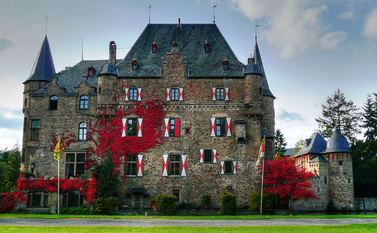
(Charlie1965nrw Photo)
Burg Satzvey, main house.
(Dguendel Photo)
Burg Satzvey, gate house.
(Alf van Beem Photo)
Burg Satzvey.
Schloss Braunfels
(ElizabethMargit Photo)
Schloss Braunfels, is a stately home that had been built from a castle built in the 13th century by the Counts of Nassau. From c1260, the castle served as the Solms-Braunfels noble family’s residential castle. After Solms Castle was destroyed by the Rhenish League of Towns in 1384, Braunfels Castle became the seat of the Counts of Solms. Over the castle’s more than 750-year-long history, building work was done many times. Particularly worthy of mention is the town and castle fire of 1679, which burnt much of Braunfels and its stately seat down. Both were then built into a Baroque residence. Braunfels Castle was rebuilt out of materials that were still on hand.
Schloss Braunfels as it appeared in 1655. Matthäus Merian.
(Ulrich Mayring Photo)
Schloss Braunfels.
(I, ArtMechanic Photo, 22 June 2005)
Schloss Braunfels.
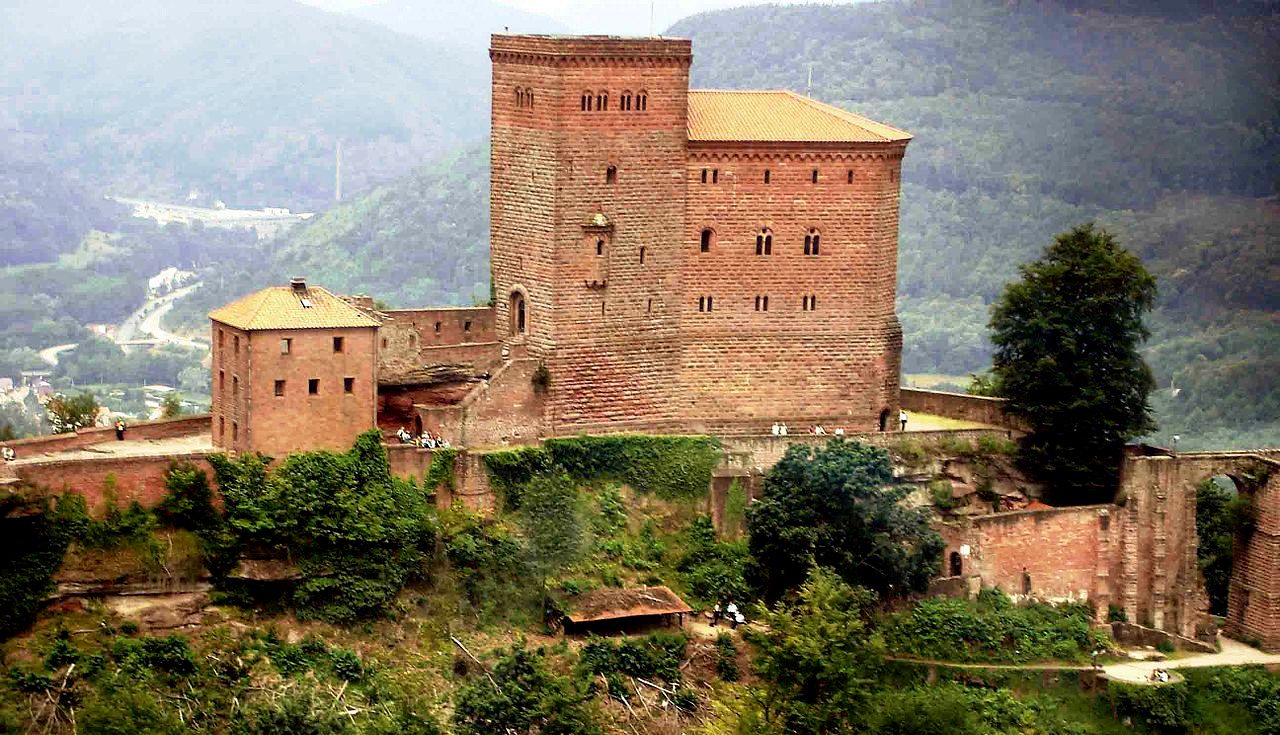
Trifels
(R. Wallenstein Photo, 29 Jan 2006)
Anweiler: Reichsburg Trifels, first mentioned in documents dated 1081. This castle was designated as a secure site for preserving the Imperial Regalia of the Hohenstaufen Emperors until they were moved to Walburg Caste in Swabia in 1220. Richard the Lionheart, King of England was kept a prisoner here, after he was captured by Duke Leopold V of Austria near Vienna in Dec 1192 as he was returning from the Third Crusade. He was handed over to Emperor Henry VI of Hohenstaufen and his period of captivity from 31 March to 19 April 1193 is well documented. Our family visited this castle often during our postings to Germany. Its a steep climb. Reichsburg Trifels was one of many castles our family visited over the years, and in fact, it was the very first for me on Saturday, 27 June 1959.
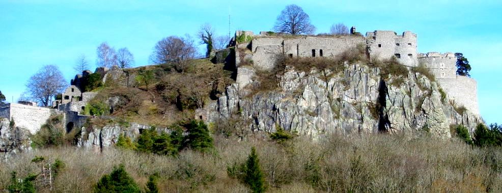
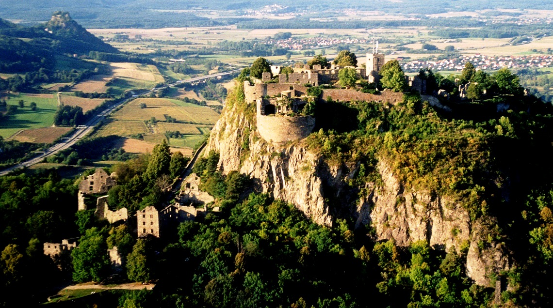
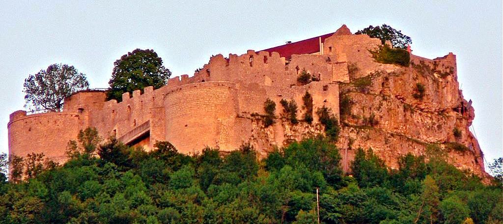
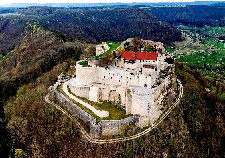
Festung Hohentwiel
(jens@storchenhof-pap…Photo)
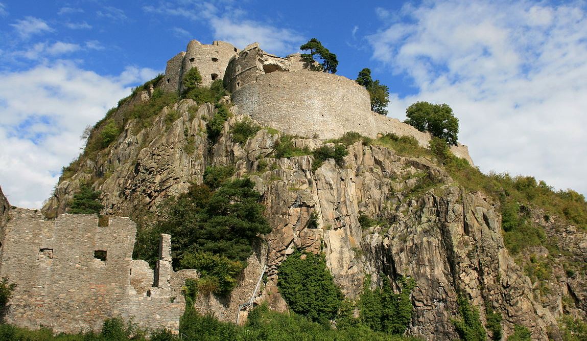
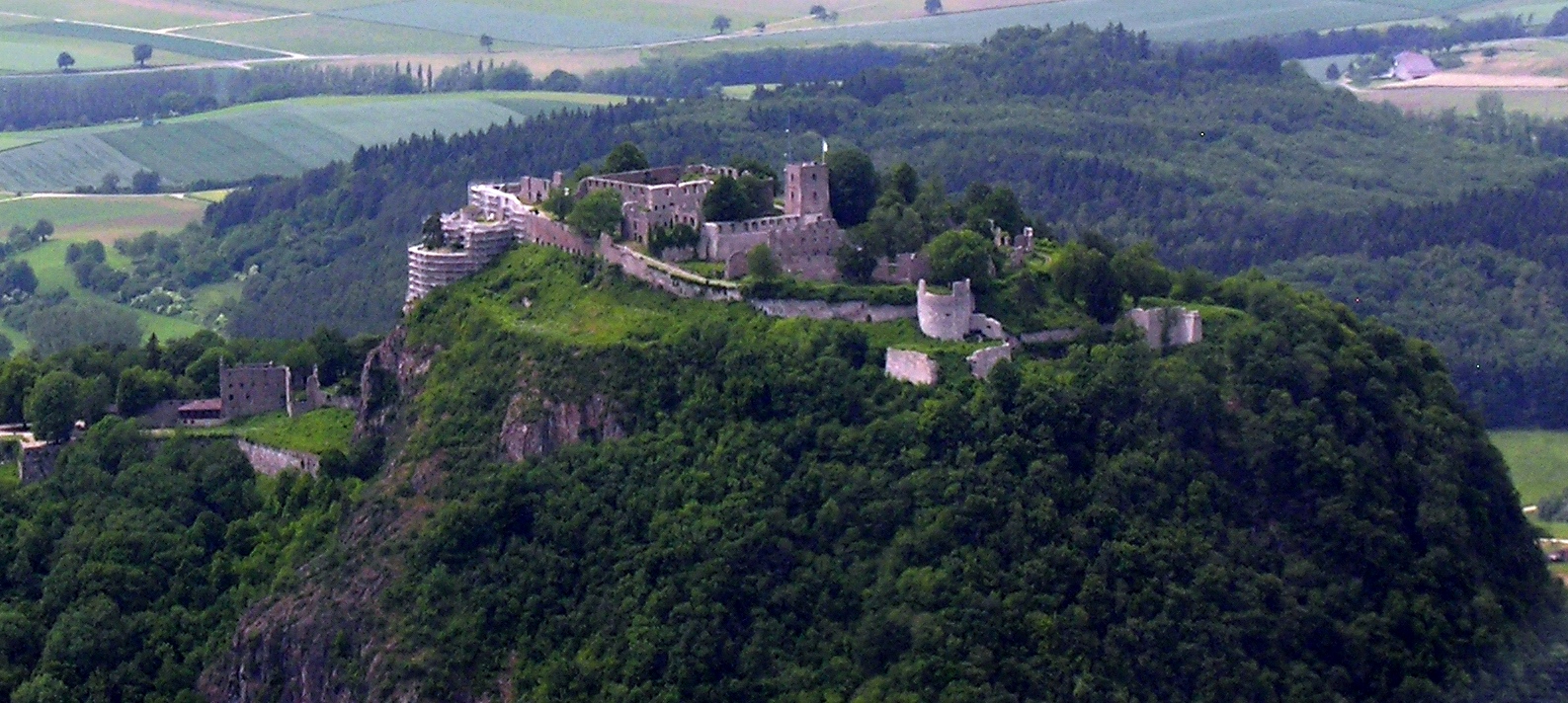
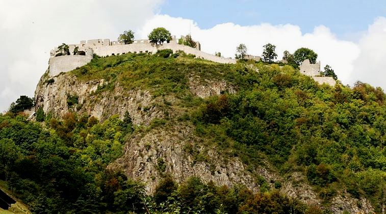
Singen: Festung Hohentwiel (Fortress Hohentwiel) is a ruin standing on top of Hohentwiel mountain (an extinct volcano). It was built in 914 using stone taken from the mountain by Burchard II, Duke of Swabia. Originally, the Monastery of St. Georg stood was within the fortress, but in 1005 it was moved to Stein am Rhein (now in Switzlerland), and the Swabian dukes lost control of Hohentwiel. In the later Middle Ages the noble families von Singen-Twiel (12th–13th centuries), von Klingen (to 1300) and von Klingenberg (to 1521) resided here. In 1521, it was passed on to Duke Ulrich von Württemberg, who developed Hohentwiel into one of the strongest fortresses of his duchy. During this time, it began to be used as a prison, and in 1526, Hams Müller von Bulgenbach, a peasant commander, was imprisoned there before he was executed.
The fortress resisted five Imperial sieges sieges in the Thirty Years’ War, under the command of Konrad Widerholt between 1634 and 1648. The effect was that Württemberg remained Protestant, while most of the surrounding areas returned to Catholicism in the Counterreformation. The castle served as a Württemberg prison in the 18th century and was destroyed in 1800 after being peacefully handed over by the French. Today the former fortress Hohentwiel is the largest castle ruin in Germany. The modern city of Singen nestles at the foot of the mountain.
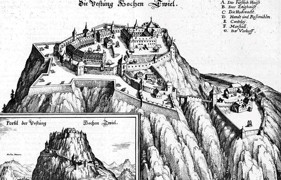
Festung Hohentwiel, 1643, Merian illustration.
(Frank Vincentz Photo)
Festung Hohentwiel.
(Hansueli Krapf Photo)
Festung Hohentwiel, aerial view.
(Frank Vincentz Photo)
Festung Hohentwiel.
(Gladys80 Photo)
Festung Hohentwiel.
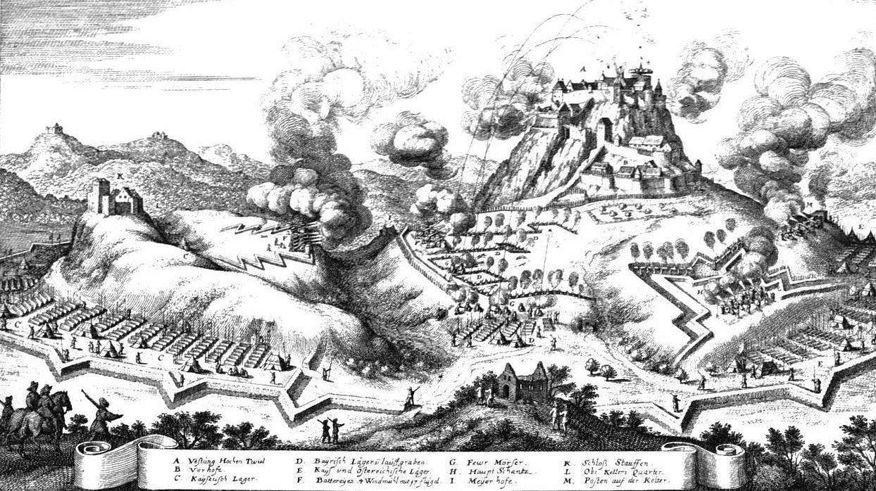
Siege of Festung Hohentwiel, 1641.
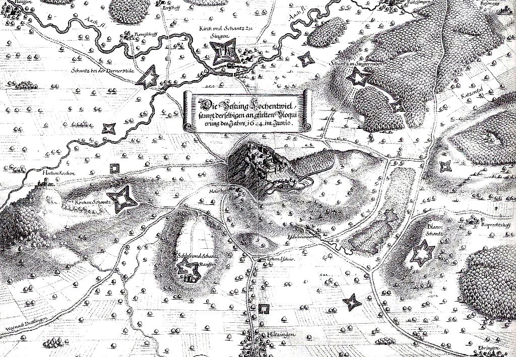
Blockade of Festung Hohentwiel, 1644.
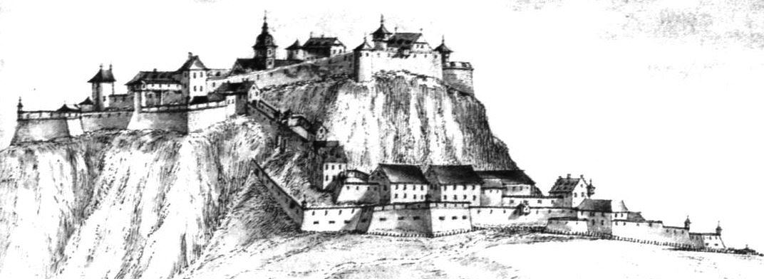
Festung Hohentwiel, 1692.
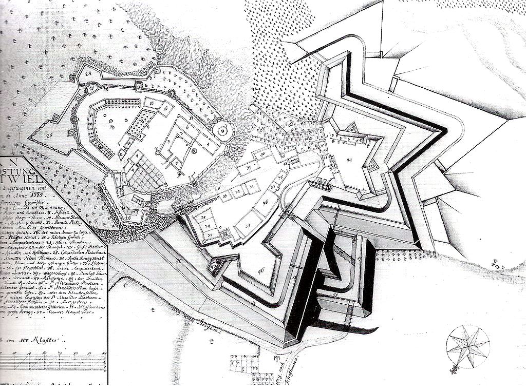
Festung Hohentwiel, ground plan, 1735.
(Peter Stein Photo)
Festung Hohentwiel, aerial view.
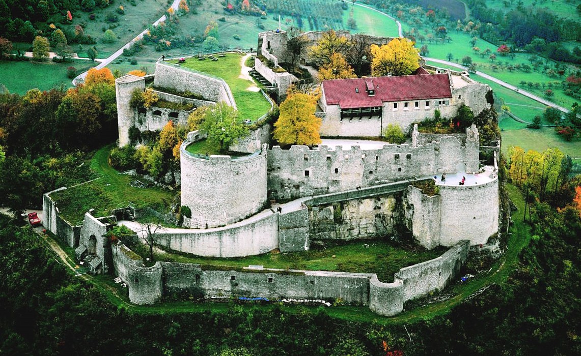
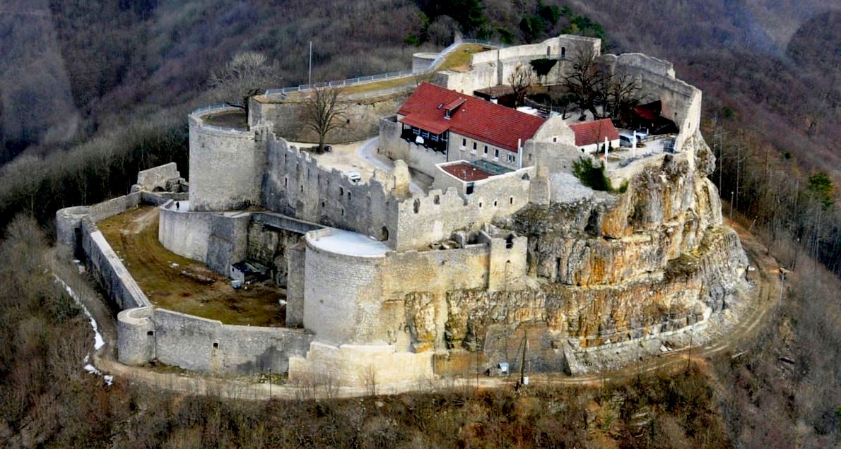
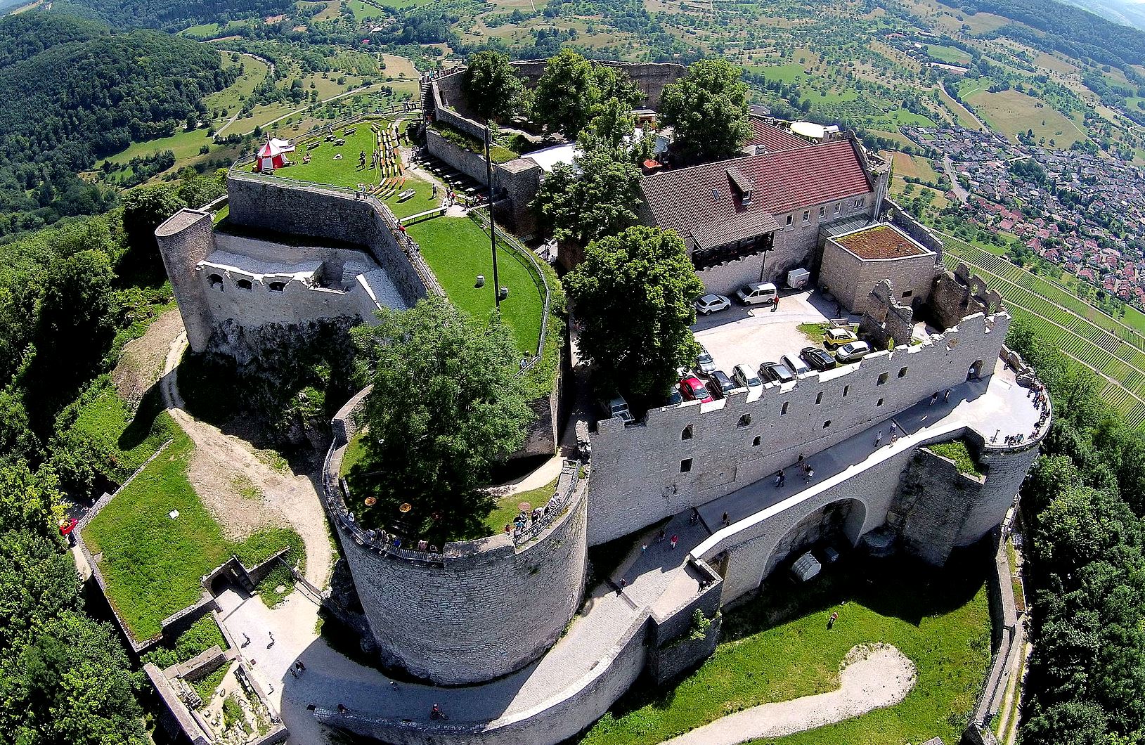
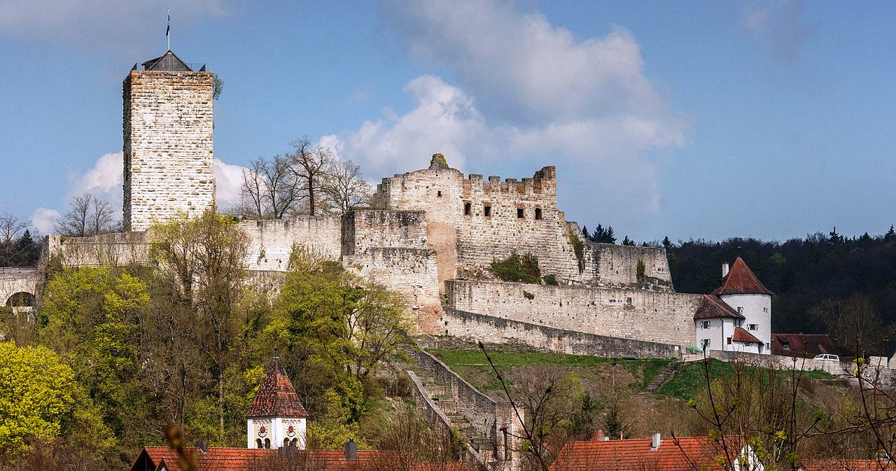
Burg Hohenneuffen
(Heribert Pohl Photo)
Neuffen: Burg Hohenneuffen is a large hill fort now in ruins, standing above the town of Neuffen in the district of Esslingen in Baden-Württemberg. The high medieval castle ruins are located east of Neuffen at 745.4 m above sea level on “fortress mountain”, a white Jurassic rock on the edge of the Swabian Alb. The castle guards a strategically favorable location on the Albantrauf. The Hohenneuffen was already settled in ancient times. In the late Celtic La Tène period (450 to 1 BC) it served as an outpost of the well-known Heidengraben -oppidum (Celtic fort c1 BC), which included the entire “Erkenbrechtsweiler peninsula” of the Swabian Alb. The origin of the name (1206 Niffen ) is controversial. On the one hand, it is traced back to a Celtic word * Nîpen and then interpreted as a ” battle castle “. Another etymology derives the name of the other hand Germanic * hnîpa meaning “steep slope, mountainside”.
The castle was built between 1100 and 1120 by Mangold von Sulmetingen, who later called himself von Neuffen. The first mention of the castel is found in a document dated 1198, indicating that at that time it was owned by the noble free von Neuffen family, to which the minstrel Gottfried von Neifen belonged. At the end of the 13th century the castle went to the Lords of Weinsberg, who sold it to the House of Württemberg in 1301. In 1312, the castle proved its ability to defend itself in the internal conflicts of the Holy Roman Empire (the Imperial War), demonstrating that it could not be taken.
The expansion of the Hohenneuffen into a state fortress began as early as the 15th century. The decisive building measures for the fortified complex were not undertaken by Duke Ulrich until the middle of the 16th century. The outer works, round towers, bastions, a commandant’s office, casemates, stables the armoury and two cisterns were built. The fotification thus created existed for two centuries without any major changes. In 1519, Hohenneufen was forced to surrender to the Swabian Federation. In the German Peasant Wars in from 1524, it could not be taken again.
The Hohenneuffen was besieged for more than a year during the Thirty Years’ War. In November, the fortress commander, Captain Johann Philipp Schnurm, and the troubled crew decided to negotiate a surrender with the enemy, which provided for a free withdrawal with weapons and all belongings. On 22 November 1635, Schnurm handed the fortress over to the imperial troops after a 15-month siege. Contrary to the promises made, the team was forced to serve in the imperial army, and Schnurm lost his property. A legend, which does not correspond to the historical events, says the following: The people at the castle gave their donkeys the last grain that they had left, slaughtered it and threw the filled stomach of the animal into the camp of the enemy. Because they believed that the besieged still had enough supplies, they lost patience and moved away. Since then, the donkey has been the “mascot” of the city of Neuffen.
The Württemberg Duke Karl Alexander planned to develop the Hohenneuffen into a fortress based on the French model in the 18th century; but he died before completion. His successor Carl Eugen abandoned the plan in view of the high costs and dubious military benefits. In 1793 plans were made to raze the fortress and the remains were to be sold for use as building materials. These plans were approved, and from 1795 it was no longer used. It was finally released for demolition in 1801, which began in 1803. The residents of the area were happy about having access to cheap building material. It was not until 1830 that they began to secure the remains, and in the 1860s the ruins were made accessible to the public. In 1862 a restaurant was set up in the building in the upper courtyard.
Like other fortresses, the Hohenneuffen served at times as a state prison, where important prisoners were arrested and, if necessary, tortured. The fates of some are known. A young Count von Helfenstein, Friedrich, fell to his death in 1502 while attempting to escape. In 1512 Duke Ulrich had the abbot of the Zwiefalten monastery, Georg Fischer, detained here. The elderly Tübingen Vogt Konrad Breuning was also subjected to the prince’s arbitrariness in 1517 and was beheaded after imprisonment and torture in Stuttgart. In the 17th century, Mattäus Enzlin, Duke Friedrich’s Chancellor, suffered a similar fate. In 1737 Joseph Suss became Oppenheimer, the Jewish court factor and personal financial advisor to Duke Karl Alexander. Joseph was imprisoned in the Hohenneuffen for a few weeks before he was transferred to the Hohenasperg fortress and executed in 1738, as a victim of judicial murder at the gates of Stuttgart.
During the Second World War, the Hohenneuffen was an air station. The military governments of the zones of occupation founded the states of Württemberg-Baden in the American zone in 1945/46 and Württemberg-Hohenzollern and Baden (although it only included the southern part of the country) in the French zone. When it became clear in 1948 that a constitution was being drawn up for western Germany, some politicians took the initiative; they wanted the countries in the south-west to merge. The head of government of Württemberg-Baden, Reinhold Maier, invited the governments of the three countries to a conference on 2 August 1948, which took place in the Hohenneuffen. He wanted to make a first approximation. A delegation led by Leo Wohleb, who was an uncompromising advocate for the restoration of the state of Baden. Württemberg-Hohenzollern was represented by its Interior Minister Viktor Renner. The delegations included ministers, party leaders, MPs and officials from the three countries.
The venue was chosen with care. The wide view of the country and, above all, the drastic zone boundary between the districts of Reutlingen and Nürtingen, a few kilometers away, is impressive. Separated from their governments and the public, the participants wanted to debate objectively, well served with valley wine . In the end, an agreement did not come about, but the meeting had given impetus and important groundwork had been set. This three-country conference which took place in the Hohenneuffen thus marks the beginning of the long-term dispute over the formation of the south-western state of Baden-Württemberg, which was launched in 1952. Today the Hohenneuffen with its restaurant, beer garden and kiosk is a popular destination. Entry to the castle is free. The casemates, some of which are accessible, are worth seeing .
The lighting of the outer walls on Sundays and public holidays is also very impressive. The facility, originally donated by the Neuffen citizen Otto Krieg in the 1950s, was completely renovated in 1984 by the Stadt- und Kulturring Neuffen eV and is also maintained by the latter. (Walter Bär: The Neuffen, history and stories about the Hohenneuffen. Published by the city of Neuffen, 1992)
(ufo 709 Photo)
Burg Hohenneufen, aerial view.
(Swabian Tourismusverband Photo)
Burg Hohenneufen, aerial view.
(MFSG Photo)
Burg Hohenneufen, aerial view.
(Aerial video capture Photo)
Burg Hohenneufen, aerial view.
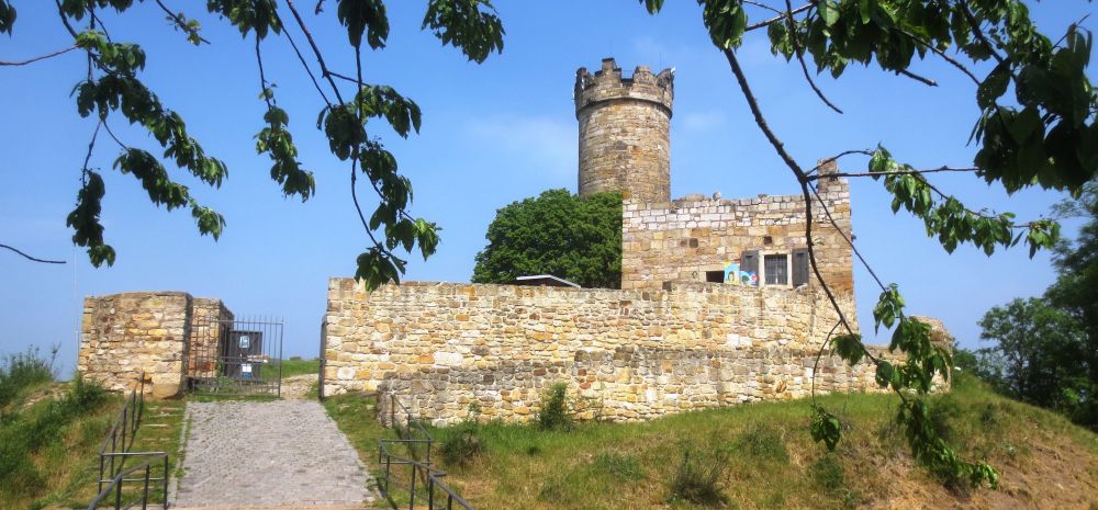
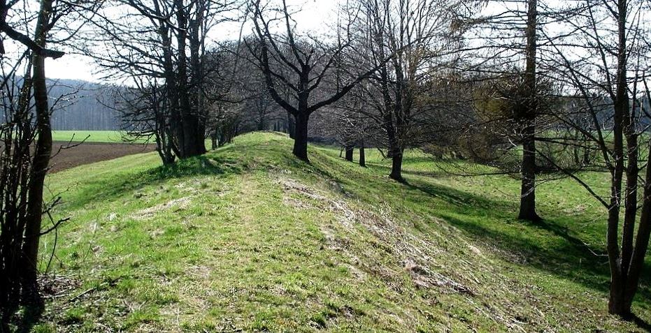
Heidengraben
(Genet Photo)
The Heidengraben, a Celtic oppidum (a fortified, urban-like settlement from the La Tène period – late Iron Age), that dates to the 1st century BC. It was located on the Swasbian Alb near Grabenstetten. The remains of the fortification of the oppidum are still visible as a rampart. The oppidum had an outer and an inner ring of fortifications, inside the latter was the settlement called Elsachstadt (after the Elsach brook, which rises below the oppidum in the Falkensteiner cave). The oppidum is located on the Grabenstetten peninsula , a part of the Alb plateau that is only connected to the rest of the Alb plateau by a narrow strip south of Grabenstetten, so that the Alb is a natural fortification. This location made it possible to enclose an area of around 16.6 km² by building four short fortifications. These fortifications separated the present day area of the municipality of Hülben, the Burgwald area between Beurener Fels and Brucker Fels , the connection to the rest of the Alb plateau and the Lauereck area bordering the inner fortification in the south. The Elsachstadt settlement had an area of 1.53 km² and was located west of the present day municipality of Grabenstetten.
Apparently the Grabenstetten peninsula was settled a few centuries before the oppidum was established. There are graves from around 1000 BC near today’s Burrenhof. Some of the burial mounds that can still be seen date from c500 BC. This may have been the location of Riusiava, indicated in the ancient atlas of Ptolemy. Scientific excavations are continuing. The Heidengraben played a major role in the so-called Celtic concept of the state of Baden-Württemberg. (The Heidengraben – A Celtic oppidum in the Swabian Alb . Theiss Verlag, 2012)
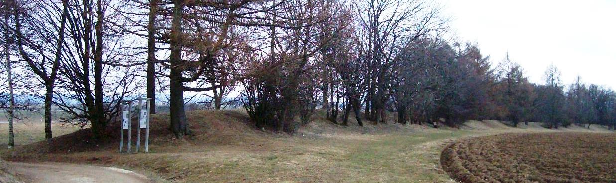
(Aspirinics Photo)
The tree-covered wall is a remnant of the inner fortification ring on the northern edge of Elsachstadt.
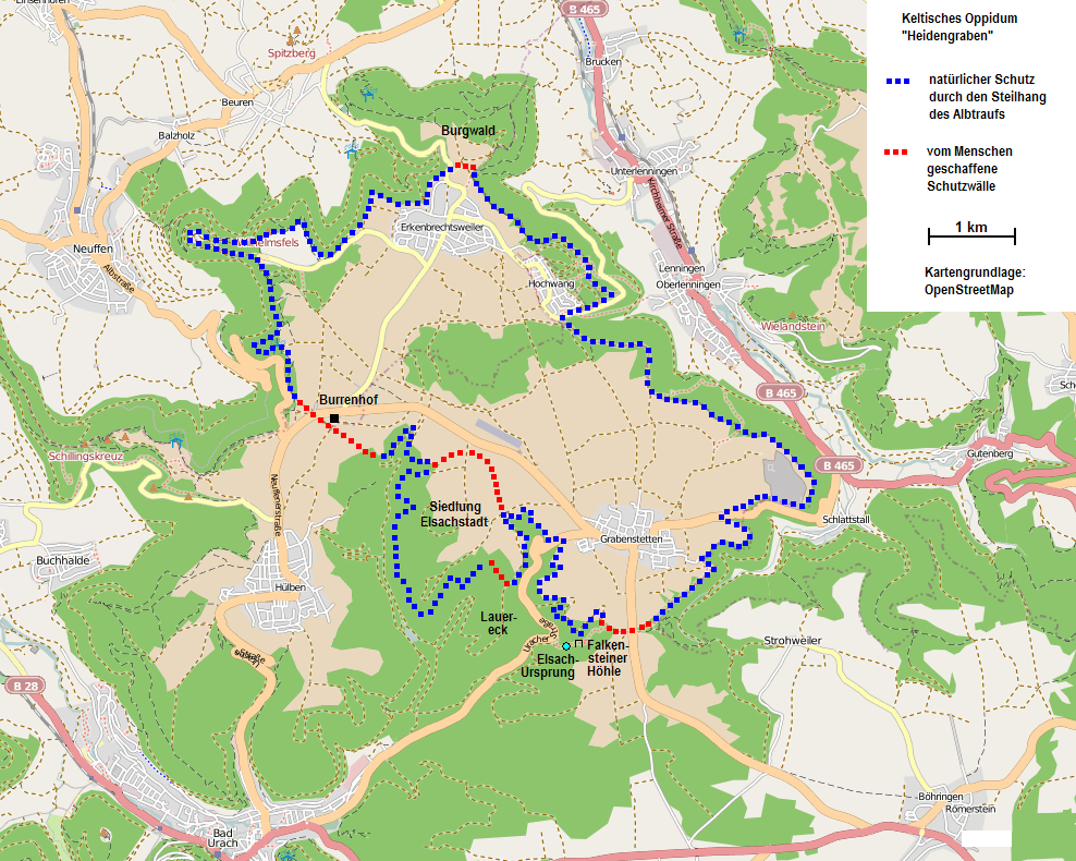
Course of the Heidengraben.
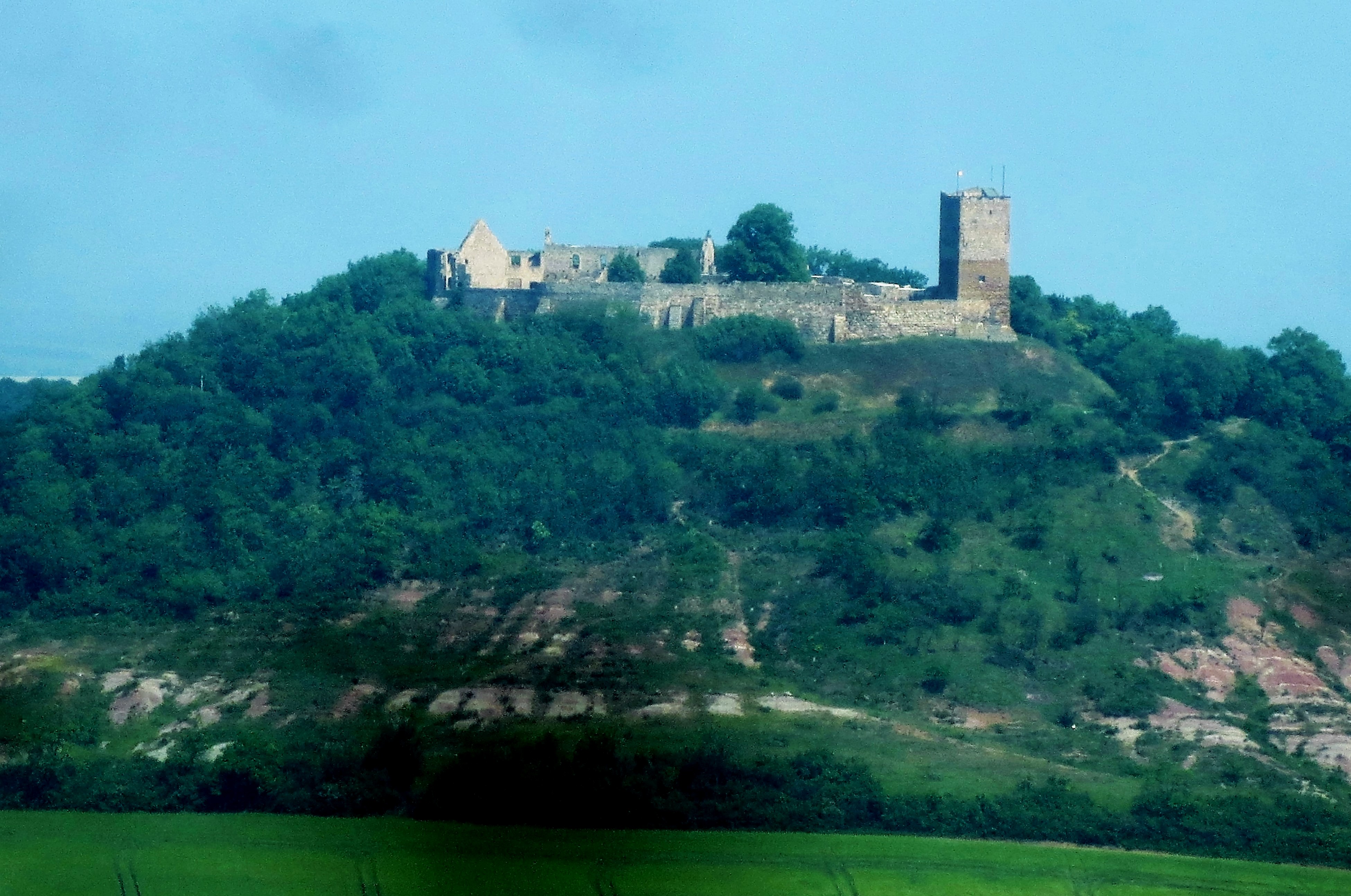
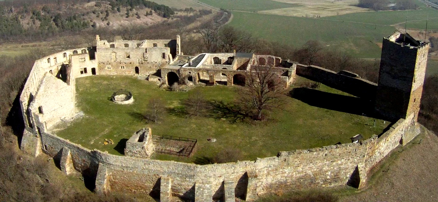
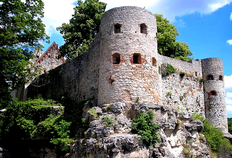
Burg Pappenheim
(BKLuis Photo)
Burg Pappenheim (Burg Kalteneck) was the scene of numerous confrontations of the dukes of Bavaria and King Henry Raspe against the imperial forces in the 13th Century. Battles andconflict circled the castle in several waves until the 14th and 15 Century. In 1633, during the Thirty Yearsè War, the castle and town were conquered and destroyed by Swedish regiments. In 1703 during the Spanish war of succession, Pappenheim was again looted, this time by French troops and the castle was partially destroyed after bombardment. During the War of the Spanish Succession, the castle was shelled for two days by French troops, until it was finally captured. Since then the castle has been uninhabited. Pappenheim is a town in the Weißenburg-Gunzenhausen district, in Bavaria, situated on the Altmühl river.
(Tilman2007 Photo)
Burg Pappenheim.
(Dark Avenger Photo)
Burg Pappenheim.
(Derzno Photo)
Burg von Pappenheim.